Purley on Thames
| Purley on Thames | |
|---|---|
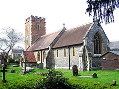 St. Mary's Church of England Parish Church, Purley-on-Thames | |
 Mapledurham meadows and woods facing Purley from above the Thames Path National Trail at Purley. | |
 Purley on Thames Location within Berkshire | |
| Area | 4.27 km2 (1.65 sq mi) |
| Population | 4,394 (2011 census)[1] |
| • Density | 1,029/km2 (2,670/sq mi) |
| OS grid reference | SU6676 |
| Civil parish |
|
| Unitary authority |
|
| Ceremonial county |
|
| Region | |
| Country | England |
| Sovereign state | United Kingdom |
| Post town | Reading |
| Postcode district | RG8, RG31 |
| Police | Thames Valley |
| Fire | Royal Berkshire |
| Ambulance | South Central |
| UK Parliament | |

Purley on Thames (locally known as Purley) is a village and civil parish in Berkshire, England. Purley is centred 3 miles (4.8 km) north-west of Reading, 1 mile (1.6 km) east of Pangbourne, and 22 miles (35 km) south-east of Oxford. Consequently, the Reading urban area is the principal social, economic and cultural centre for the people of Purley. Historically, Purley comprised three separate manors and associated settlements, these being Purley Magna to the east, Purley Parva to the north-west, and La Hyde, to the west. In the centre there is an historic area named variously Lething or Burley (Domesday) which accommodated traders and craftsmen alongside the main Reading to Oxford road.
Development[]
Purley lost most of its old houses due to emparkment around 1800 and redevelopment in the 20th century. It is bounded to the north by a stretch of the River Thames, to the east by West Reading and part of Tilehurst in Reading Borough, to the west by Pangbourne and to the south by Tilehurst and Sulham. After the sale of the estate of Purley Magna in the 1920s most of the eastern part of the parish has been developed but there is easy access to rural areas to the west and south. The area encompassing the other manors has also retained a rural character.
Changes in the 20th century began with ribbon development along the Oxford Road and Long Lane and in recent years these properties have been redeveloped with modern housing estates. The Purley River Estate was sold off in small plots in the 1930s and for many years suffered much non-planned development. As a result of the guidance plan agreed during the 1960s, it has gradually developed from self built, timber dwellings and converted railway carriages, to an area with more conventional 'everyday' houses. The gradual upgrading of the area has resulted in a diverse range of housing styles.
Geography[]
Previously a rural village, Purley is essentially a suburb of Reading, though within the boundaries of West Berkshire Council. The majority of homes in Purley are detached houses, with minorities of small housing and shared ownership properties and several council estates. The area is largely unaffordable for most of the population - as of 2016, the average price of a property in Purley is £413,268 and the median UK wage is £26,500; the average house price is thus nearly 16 times the average salary.[2][3]
Due to its proximity to the River Thames, Purley has suffered severe flooding.[4] It is not widely known that the part of Purley closest to the river has changed radically, with most properties having been built since the 1970s and, with a very few exceptions, it was a condition of planning approval that the houses were built at or above the 1947 flood level. Some builders chose to make the whole of the ground floor as garaging and other non-habitable areas with the living accommodation being on the first floor. Some gardens and roads flood on occasion but very few houses have been damaged. Homes that have been damaged by flooding are generally those whose owners have chosen to use as accommodation the non-habitable areas. The flood alleviation scheme in the form of a clay Bund and a Pumping Platform [5] was completed by the Environment Agency in late 2014.
Amenities[]

Purley has two primary schools with three other primary schools and Denefield Academy within a short distance of its boundaries.
It is within easy reach of Tilehurst and Pangbourne stations on the GWR and has a frequent bus (no 16) service to Reading its major neighbour and an infrequent service (no 143).
It is bounded to south and west by the North Wessex Downs area of outstanding natural beauty and to the north by the Chilterns AONB and has a good range of habitats from river and woodland supporting a diverse range of creatures.
The Thames Path National Trail beside the river and a set of 12 designated footpaths provide many opportunities for ramblers. There are two recreation areas with a bowling green and Pike Shaw woods in the ownership of the Parish Council.
There are three community halls: The Barn, the Memorial Hall and St Mary's Church, which host a large number of clubs and societies
Demography[]
The population has around 88% White British ethnicity, 4% other white ethnicity; residents identifying with an Asian ethnicity constituted 3%, with a Caribbean or African ethnicity 1% and those with a mixed ethnicity, 2%.[6] This differs according to the individual area within Purley; in the Sovereign social housing block, for example, 44% of children are of mixed Afro-Caribbean and White descent, with all of these children living with their non-minority, single mothers.
| Output area | Homes owned outright | Owned with a loan | Socially rented | Privately rented | Other | km2 roads | km2 water | km2 domestic gardens | Usual residents | km2 |
|---|---|---|---|---|---|---|---|---|---|---|
| Civil parish | 667 | 768 | 97 | 121 | 15 | 0.165 | 0.275 | 0.706 | 4,394 | 4.27 |
Transport[]
The parish is crossed from east to west by both the GWR and the A329. Although the main line railway passes through Purley, it is mostly hidden in a deep cutting and the nearest stations are those at Tilehurst and Pangbourne.
Bus[]
Purley is served by Reading Buses service 16 and Thames Travel service 143. For those with mobility problems, ReadiBus provides door to door minibus services and the Pangbourne and District Volunteer Centre provides help getting to medical facilities.
River[]
Mapledurham Lock is within the parish despite its name.
Government[]
The civil parish of Purley on Thames stretches roughly 1.5 km both north–south and east–west and is within the area of West Berkshire Council (Unitary). It has its own Parish Council of 13 elected members with the Parish Office at Goosecroft (off Beech Road) The eastern half is almost completely redeveloped but the western half includes meadow land alongside the Thames and agricultural land on the north slope of the escarpment. There are small settlements in the extreme west (around Sulham Home Farm) and in the north west around Springs/Westbury Farms. The parish also includes Mapledurham Lock on the Thames. The parish is within the Reading West parliamentary constituency.[7]
History[]
Early settlements[]
Purley has been settled since at least Saxon times. The original settlements were based on Purley Magna (to the east), Purley Parva (to the north-west) and Purley La Hyde (to the west). Ownership of these manors changed several times over successive centuries but the parish remained almost entirely agricultural until development began in the 20th century, with a population of 150–200. Since then it has grown to 4,232 (2001 Census) and around 5,300 people today.
Buildings[]
In medieval times the parish had three manors, Purley Magna centred on where the church is today, Purley Parva centred on Westbury Farm and Purley La Hyde centred on what is now Sulham Home Farm and Purley Hall.
- Manor house and mansion
A timbered Elizabethan Manor house was constructed in the 1540s, to be replaced by a brick house in 1740. This was demolished around 1800 to be replaced by the Purley Park Mansion designed by Wyatt in 1800 and on the brow of the hill to be well away from flooding. At the same time most of the eastern part of the parish was emparked; a new road (New Hill) constructed to provide access to the residual village and the Turnpike Highway diverted to the south.
In 1948, the Purley Park mansion and purchased to provide a home and school for people handicapped with Down syndrome.[8] While the Mansion House has now been converted to flats, the Purley Park Trust continues to support adults with learning difficulties with care homes in the former grounds.
- Purley Hall
Purley Hall was built around 1608 to replace the manor house of Purley La Hyde and was home to personages such as Warren Hastings, Lady Baden-Powell (as a child) and Thomas Hawes (of South Sea Bubble fame)
- Farm buildings
When the Purley Park Mansion was built, the farm was moved further west and was home to the South Berks Hunt for many years. Its Master of fox hounds, Cecil Aldin, ran a Remount Depot there in World War I, employing his friend and fellow artist, Alfred Munnings as a horse doctor. After World War II the property was sold to Messrs G Percy Trentham who used it as the head offices for their civil engineering business. In the 1990s this too was redeveloped and the barn which had originally been adjacent to the church, donated to the Parish Council as a community facility.
Smallholdings[]
Several smallholdings were established between World War I and World War II, one by Mortimer Menpes, the artist and friend of Whistler. These have almost all now been redeveloped.
Church[]
This section needs additional citations for verification. (May 2021) |
Architecture[]
The church was described as 'ancient' in a founding charter of Reading Abbey in 1121. It is believed it was burnt down in 1135 in the Stephen/Matilda anarchy and replaced by a Norman church around 1150. The new church was built on an excavated platform and graves dating from the 10th century or 11th century were discovered in 1982 only about a foot from the surface. This church was modified and added to in the 14th and 17th centuries and completely rebuilt in 1870 in the Gothic revivalist style by G. E. Street. A further major extension was added in 1983.
Ecclesiastical parish priest[]
- History
The list of rectors dates from the mid-14th century. Purley's foremost clergyman suffered ejection during the 120 years of Christian sectarian conflict commencing with Edward VI's reign. These included Richard Gatskyll, in Edward VI's reign, for being a Catholic, John Leke, in Mary I's reign, for having been married, Thomas Handcock, in 1563, for not being Protestant enough for the church overseen by Elizabeth I and Daniel Reynor, in 1662, who was a Congregationalist, and so unwilling to conform to the Act of Uniformity 1662 passed after the Restoration of Charles II.
- Present
The Church of England Rector of St. Mary's Purley is David Archer.[9]
References[]
- ^ Jump up to: a b Key Statistics: Dwellings; Quick Statistics: Population Density; Physical Environment: Land Use Survey 2005
- ^ House Prices in Purley On Thames, Reading, Berkshire
- ^ UK average salary is £26,500 but figures reveal huge pay gap between rich and poor - official earnings list - Mirror Online
- ^ Purley residents rescued as River Thames rises - BBC News
- ^ West Berks Council application no. 14/01372/FUL
- ^ West Berkshire Council - Can't Find Page
- ^ "Election Maps". Ordnance Survey. Archived from the original on 7 March 2008. Retrieved 27 February 2008.
- ^ "Account of Purley on Thames - Purley Park Trust" (PDF). Project Purley. 4 April 2017. Retrieved 6 October 2020.
- ^ "Whos's who". St. Mary's Purley. Retrieved 6 October 2020.
External links[]
| Wikimedia Commons has media related to Purley on Thames. |
| show Settlements in West Berkshire |
|---|
| show Authority control |
|---|
- Populated places on the River Thames
- Suburbs of Reading, Berkshire
- Villages in Berkshire
- West Berkshire District
- Civil parishes in Berkshire