Avington, Berkshire
| Avington | |
|---|---|
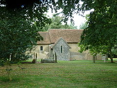 Parish church of SS Mark and Luke | |
 Avington Location within Berkshire | |
| OS grid reference | SU3768 |
| Civil parish | |
| Unitary authority | |
| Ceremonial county | |
| Region | |
| Country | England |
| Sovereign state | United Kingdom |
| Post town | Hungerford |
| Postcode district | RG17 0 |
| Dialling code | 01488 |
| Police | Thames Valley |
| Fire | Royal Berkshire |
| Ambulance | South Central |
| UK Parliament | |

Avington is a village and former civil parish on the River Kennet in West Berkshire, England. It is now part of the parish of Kintbury. The village is just under 1 mile (1.6 km) northwest of Kintbury village and 2 miles (3 km) east of the town of Hungerford. The Kennet and Avon Canal follows the river and passes the village.
Toponym[]
The toponym is derived from Old English and means "the enclosure (tūn) of Afa's people". The Domesday Book of 1086 records it as Avintone and a pipe roll from 1167 records it as Avintona.[1]
Parish church[]
The Church of England parish church of Saints Mark and Luke is an 11th-century Norman building. It consists of only a nave, chancel and late 19th-century north transept. The font is a notable piece of Romanesque sculpture and may be Saxon.[2] The south doorway is a Norman arch. The chancel has Norman vaulting and a Norman arch, both with "beakhead" ornament.[3] A few early Gothic additions to the church were made in the 13th century, including two doorways and a "low-side" window.[3] The church is a Grade I listed building.[2]
References[]
- ^ Ekwall 1960, Avington
- ^ a b Historic England. "Church of St Mark and St Luke (Grade I) (1319539)". National Heritage List for England. Retrieved 6 August 2018.
- ^ a b Pevsner 1966, p. 75.
Bibliography[]
- Ditchfield, PH; Page, William, eds. (1924). "Avington". A History of the County of Berkshire. Victoria County History. Vol. IV. assisted by John Hautenville Cope. London: The St Katherine Press. pp. 21–24.
- Ekwall, Eilert (1960) [1936]. Concise Oxford Dictionary of English Place-Names (4th ed.). Oxford: Oxford University Press. Avington. ISBN 0198691033.
- Pevsner, Nikolaus (1966). Berkshire. The Buildings of England. Harmondsworth: Penguin Books. p. 75.
External links[]
| Wikimedia Commons has media related to Avington, Berkshire. |
- Avington in the Domesday Book
This Berkshire location article is a stub. You can help Wikipedia by . |
- Villages in Berkshire
- Former civil parishes in Berkshire
- Kintbury
- Berkshire geography stubs