East Ilsley
| East Ilsley | |
|---|---|
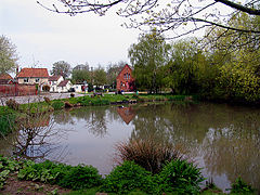 East Ilsley's village pond and small green with homes | |
 East Ilsley Location within Berkshire | |
| Area | 15.02 km2 (5.80 sq mi) |
| Population | 1,571 (2011 census)[1] |
| • Density | 105/km2 (270/sq mi) |
| OS grid reference | SU4981 |
| Civil parish | |
| Unitary authority |
|
| Ceremonial county | |
| Region | |
| Country | England |
| Sovereign state | United Kingdom |
| Post town | Newbury |
| Postcode district | RG20 |
| Dialling code | 01635 |
| Police | Thames Valley |
| Fire | Royal Berkshire |
| Ambulance | South Central |
| UK Parliament | |
| Website | Official website |

East Ilsley is a village and civil parish in the Berkshire or Lambourn Downs northern part of West Berkshire, north of Newbury centred immediately east of the A34 road dual carriageway which passes through the length of the village from north to south. It is in the ceremonial and historic county of Berkshire and has the vast majority of its buildings in a traditional clustered centre.
Amenities[]
The village has a highest grade listed church that is mostly made from medieval stone, a minority of other buildings close by which are listed and pubs.
East Ilsley has an area to picnic by the pond, feeding the ducks, spend a few moments. Football is made available by local subscription on the recreation playground.[2]
History[]
Sheep market[]
In 1620 East Ilsley was granted a charter to hold a sheep market in the village, however informally held from the reign of Henry II of England. This became the second largest sheep market, after Smithfield, London throughout the 19th century.[3][4]
Hildersley[]
The parish was anciently called Hildersley, as in a medieval inscription in the church. West Ilsley was a hamlet in Ilsley. Ilsley has been attributed by antiquaries as a leading contender for the uncertain site of the Battle of Ashdown (Alfred the Great's victory against the Danes).[3][4] Hilde-Laege a strong plausible root of Hildersley means "Battle place".
Economy in the 1870s[]
Its real property (farms and homes) were worth £4,490 (equivalent to £432,779 in 2019) and its population in the United Kingdom Census 1871 was 746. It had 130 houses. This capital was remarked in a contemporary description as owned by a few. The manor belonged to Capt. Woodley, and great part of the land to Col. Robert Loyd-Lindsay. The benefice remained in the default form of a rectory (rather than a vicarage) in the diocese of Oxford, worth £722 (equivalent to £69,592 in 2019). Patron, Magdalen College, Oxford. There was by this time a National School.[4]
Notable inhabitants/births here[]
- John Hilsey, head of a Dominican order and bishop of Rochester turned agent of Henry VIII's dissolution of the monasteries, born here;
- R. Wightwick, the co-founder of Pembroke College, Oxford, rector.[4]
Church[]
The church is partly Norman; has an early English style chancel, and an embattled tower; it was enlarged and repaired in 1845 and contains an old monument of one of the Hildesleys, ancient lords of the manor.
Transport[]
Public transport[]
- Rail
East Ilsley's nearest station is Didcot Parkway, providing direct services to the West, West Midlands and London. The South Coast and East Anglia can be reached by changes at Reading/twice in London respectively. Historically, the village was served by Compton railway station, open from 1882 to 1962, on the Didcot, Newbury and Southampton Railway.
- Buses
East Ilsley is served by buses 6 and 6A from Newbury.[5]
Roads[]
See A34 road.
Footpaths[]
The Ridgeway long-distance footpath passes through a subway below the A34 approximately one mile north of the village.
Racehorse training[]
Racehorses have been trained at East Ilsley for about 200 years, as an offshoot from the economic centre of training in the UK and Ireland, ten miles west at Lambourn.[6]
Demography[]
Of its 216 homes in 2011, majority in this parish were owner-occupied; just over 10% were socially rented. Further context is as follows:
| Output area | Population | Homes | Owned outright | Owned with a loan | Privately rented | Socially rented | Other | km2 | km2 Greenspace[n 1] | km2 gardens | km2 road[1] |
|---|---|---|---|---|---|---|---|---|---|---|---|
| East Ilsley (civil parish) | 538 | 216 | 65 | 85 | 28 | 29 | 9 | 12.6 | 12.1 | 0.1 | 0.2 |
Nearest places[]
| show Nearest Places (by Civil Parish) |
|---|
Notes and references[]
- Notes
- ^ Comprises cultivated fields, pasture, woodland and common.
- References
- ^ Jump up to: a b Key Statistics: Dwellings; Quick Statistics: Population Density; Physical Environment: Land Use Survey 2005
- ^ East Ilsley PC
- ^ Jump up to: a b A Topographical Dictionary of England. S. Lewis (1848). London: Samuel Lewis, p.691.
- ^ Jump up to: a b c d Imperial Gazetteer of Britain John Marius Wilson (1870-72). (University of Portsmouth visionofbritain.org.uk website). Retrieved 2014-12-03
- ^ "Services effective from 18 February 2013" Archived 19 August 2013 at the Wayback Machine Newbury and District Transport. Retrieved 2014-12-03.
- ^ Curling, Bill (1977), Derby Double: The Unique Story of Racehorse Trainer Arthur Budgett, London: William Luscombe (Mitchell Beasley), p. 25, ISBN 0-86002-164-5
External links[]
| Wikimedia Commons has media related to East Ilsley. |
- Royal Berkshire History: East Ilsley
- East and West Ilsley - voluntary-run Communicator (forum) and News
- East Ilsley History Society
| show Settlements in West Berkshire |
|---|
| show Authority control |
|---|
- Villages in Berkshire
- West Berkshire District
- Civil parishes in Berkshire