Putrajaya
Putrajaya
Prang Besar / Air Hitam | |
|---|---|
| Federal Territory of Putrajaya Wilayah Persekutuan Putrajaya (Standard Malay) | |
| Other transcription(s) | |
| • Malay (Jawi) | ڤوتراجاي |
| • Chinese | 布城 |
| • Tamil | புத்திராசெயா |
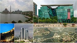 Top left to right: Putra Mosque and Perdana Putra, Ministry of Health building Bottom left to right: Ministry of Finance Complex, Putrajaya, high rise ministry complexes, Putrajaya's Precinct 1 from above | |
 Flag  Seal | |
| Motto(s): "Bandar raya Taman, Bandar raya Bestari" ("Garden City, Intelligent City") | |
 | |
 Putrajaya in Malaysia | |
| Coordinates: 02°55′48″N 101°41′24″E / 2.93000°N 101.69000°ECoordinates: 02°55′48″N 101°41′24″E / 2.93000°N 101.69000°E | |
| Country | Malaysia |
| First settled | c. 1921 |
| Planned city established | 19 October 1995 |
| Transferred from Selangor to federal jurisdiction | 1 February 2001 |
| Government | |
| • Type | Direct federal administration |
| • Administered by | Putrajaya Corporation |
| • Chairman | Muhammad Azmi Mohd Zain |
| Area | |
| • Total | 49 km2 (19 sq mi) |
| Population (2018)[2] | |
| • Total | 91,900 |
| • Density | 1,900/km2 (4,900/sq mi) |
| Human Development Index | |
| • HDI (2017)[3] | 0.877 (very high) (1st) |
| Time zone | UTC+8 (MST) |
| Postcode | 62xxx |
| Calling code | +603-88 |
| ISO 3166 code | MY-16 |
| Mean solar time | UTC+06:46:40 |
| Vehicle registration | F and Putrajaya |
| Rapid Transit | |
| Website | www |

Putrajaya (Malaysian pronunciation: [putraˈdʒaja, putrəˈdʒajə]), officially the Federal Territory of Putrajaya (Malay: Wilayah Persekutuan Putrajaya), is a planned city which functions as the administrative capital and the judicial capital of Malaysia.[4] The seat of the federal government of Malaysia was shifted in 1999 from Kuala Lumpur to Putrajaya because of overcrowding and congestion in the former,[5] whilst the seat of the judiciary of Malaysia was later shifted to Putrajaya in 2003.[6] Kuala Lumpur remains as Malaysia's national capital city per the constitution and is still the seat of the head of state (Yang di-Pertuan Agong) and the national legislature (Parliament of Malaysia), as well as being the country's commercial and financial centre. The establishment of Putrajaya was the idea of the then-Prime Minister Mahathir Mohamad. It became Malaysia's third federal territory, after Kuala Lumpur in 1974 and Labuan in 1984.
Named after the first Prime Minister of Malaysia, Tunku Abdul Rahman Putra Al-Haj, the territory is entirely enclaved within the Sepang District of the state of Selangor. Putrajaya is also a part of MSC Malaysia, a special economic zone that covers Klang Valley. In Sanskrit, "putra" (पुत्र) means son and "jaya" (जया) means "success" or "victory". The development of Putrajaya started in the early 1990s.
History and design[]

Prang Besar (Jawi: ڤراڠ بسر, alternately Perang Besar (Malay for "Great War"), was founded in 1921 on land that was jungle, as a rubber plantation by British veterans of World War I, hence the name.[7] Its land area of 800 acres (3.2 km2) expanded to 8,000 acres (32 km2), and it was merged with surrounding estates, including Estet Raja Alang, Estet Galloway and Estet Bukit Prang.
Until 1975, what is today Putrajaya, along with adjacent Cyberjaya, was under the administration of Hulu Langat (Kajang) district.
The vision of a new Federal Government Administrative Centre to replace Kuala Lumpur as the administrative capital emerged in the late 1980s, during the tenure of Malaysia's fourth prime minister, Mahathir bin Mohamad. The new city was proposed to be located between Kuala Lumpur and the new Kuala Lumpur International Airport (KLIA). Two areas were proposed: Prang Besar and Janda Baik of Pahang.[8] The new name Putrajaya was chosen for the site.
The federal government negotiated with the state of Selangor on the prospect of another federal territory. In the mid-1990s the federal government paid a substantial amount of money to Selangor for approximately 11,320 acres (45.8 km2) of land in Prang Besar, Selangor. As a result of this land purchase, Selangor now surrounds two federal territories within its borders: Kuala Lumpur and Putrajaya.
Planned as a garden city and intelligent city, 38% of the area is reserved for green spaces in which the natural landscape is enhanced.[citation needed] The plan incorporated a network of open spaces and wide boulevards. Construction began in August 1995; it was Malaysia's biggest project and one of Southeast Asia's largest, with an estimated final cost of US$8.1 billion. The entire project was designed and constructed by Malaysian companies, with only 10% of the materials imported.[citation needed]
The Asian Financial Crisis of 1997/1998 somewhat slowed the development of Putrajaya. 300 members of the Prime Minister's office staff moved there in 1999, and the remaining government servants moved in 2005. On 1 February 2001, the city was formally transferred to the federal government and declared Malaysia's third federal territory.[9]
In 2002, a rail line called KLIA Transit was opened, linking Putrajaya to KLIA in Sepang. The construction of the Putrajaya Monorail, which was intended to be the city's metro system, was suspended owing to high costs. One of the monorail suspension bridges in Putrajaya remains unused.
In April 2013, the Putrajaya government signed a letter of intent (LOI) with the government of Sejong City in South Korea to mark co-operation between the two cities.[10][11]
Government and politics[]
As of 2012 all of Malaysia's governmental ministries had relocated to Putrajaya. Government ministries and bodies remaining in Kuala Lumpur include the Ministry of International Trade and Industry (MITI), Ministry of Defence (MINDEF) and Ministry of Works (KKR), as well as Bank Negara Malaysia and Royal Malaysian Police. The Parliament of Malaysia also remained in Kuala Lumpur, as well as the Yang di-Pertuan Agong (King) of Malaysia. Foreign embassies and missions except Brunei also remained in Kuala Lumpur.
Local government in Putrajaya is the responsibility of the Putrajaya Corporation (Perbadanan Putrajaya), a special local authority. Previously it was administered by the Sepang District Council.
Putrajaya is represented in the Parliament of Malaysia by one elected MP in the Dewan Rakyat, under the seat of Putrajaya, as well as one appointed senator in the Dewan Negara.
As with the other federal territories of Malaysia, Putrajaya does not have a territorial legislature.
| Parliament | Seat Name | Member of Parliament | Party |
|---|---|---|---|
| P125 | Putrajaya | Tengku Adnan Tengku Mansor | Barisan Nasional (UMNO) |
Demographics[]
Population[]
In 2007 the population of Putrajaya was estimated to be over 30,000, which comprised mainly government servants. Government public servants have been encouraged to relocate to the city through various government subsidy and loan programs. The population had increased to 88,300 by 2015.[12]
Religious demography[]
As of 2010, the population of Putrajaya is 97.4% Muslim, 1.0% Hindu, 0.9% Christian, 0.4% Buddhist, 0.2% unknown and 0.1% other religions. The Malaysian constitution strictly defines what makes a "Malay" as an individual who professes Islam, speak Malay regularly, practises Malay customs, and has lived in or has ancestors from Indonesia, Brunei, Malaysia, and Singapore.
Infrastructure[]
Government complexes[]


- Perdana Putra – office of the Prime Minister
- Seri Perdana – official residence of the Prime Minister
- – official residence of the Deputy Prime Minister
- Palace of Justice – seat of the national judiciary (Federal Court and the Court of Appeals)
- Ministry of Finance
- Wisma Putra – Malaysian Ministry of Foreign Affairs.
- Melawati National Palace
- Istana Darul Ehsan - palace of the Sultan of Selangor
- Istana Melawati - palace of the Yang di-Pertuan Agong
- - palace of justice
- Putrajaya International Convention Centre
- Perdana Leadership Foundation, headed by former prime minister Mahathir Mohamad
Infrastructure and places of worship[]
- - the only shopping mall within Putrajaya
- Putrajaya Corporation Square
- Selera Putra
- Pusat Kejiranan Presint 9
- Putra Mosque
- Tuanku Mizan Zainal Abidin Mosque (Iron Mosque (Masjid Besi))
- Presint 10
Monuments[]
Open spaces[]
- Putrajaya Lake
- Putra Square
- Putrajaya Wetlands Park
- Taman Selatan
- Putrajaya Botanical Gardens – The biggest botanical garden in Malaysia, covering an area over 92 hectares[14]
Educational institutions[]
Kindergarten and Pre-School
- Brainy Bunch International Montessori (Presint 14)
- Government Pre-School (Pra-Sekolah) located in Primary School.
Primary & Secondary Education in Putrajaya is provided by a few schools such as:
- .
- SMK Putrajaya Presint 8 (1).
- SMK Putrajaya Presint 9.
- SMK Putrajaya Presint 9 (2).
- .
- .
- .
- .
- .
- .
- .
- .
- .
- .
- .
- .
- .
- .
- .
- .
- .
- .
- .
There are also two elite fully residential schools in Putrajaya:
- Sekolah Sultan Alam Shah
Other universities:
- Heriot-Watt University (Heriot-Watt University Malaysia) has a campus in precinct 5.[15]
International Schools
- Nexus International School Located at Presint 15.
- located at Presint 14.
Transport[]
Putrajaya is home to the world's largest roundabout, the Persiaran Sultan Salahuddin Abdul Aziz Shah with a perimeter of 3.5 km. (2.7 miles)
By car[]
Major highways[]
Putrajaya is surrounded by federal highways 29 on the western side and 30 on the eastern side. The South Klang Valley Expressway E26, connecting Pulau Indah to Kajang, runs through the northern end of Putrajaya. ELITE E6 exit 607 serves Putrajaya and also nearby Cyberjaya. Highway 29 interchanges with Damansara–Puchong Expressway (LDP) E11 in the northwestern corner of Putrajaya, linking the city with Puchong, Subang Jaya, Kelana Jaya and all the way to Kepong.
Within Putrajaya, the following roads serve as the main thoroughfares of the city.
- Persiaran Persekutuan
- Persiaran Sultan Salahuddin Abdul Aziz Shah (The world's largest roundabout with a diameter of 3.5 km (2.2 miles))
- Persiaran Utara
- Lebuh Sentosa
- Persiaran Barat
- Persiaran Selatan
- Persiaran Timur
- Persiaran Perdana (Boulevard)
List of road bridges[]

- Seri Perdana Bridge
- Putra Bridge
- Seri Wawasan Bridge
- Seri Bakti Bridge
- Seri Saujana Bridge
- Seri Bestari Bridge
- Seri Setia Bridge
- Seri Gemilang Bridge
Public transport[]
Rail[]
The only direct rail connection to Putrajaya is the 7 KLIA Transit line through the KT3 Putrajaya & Cyberjaya station within the Putrajaya Sentral transportation hub, which connects to KL Sentral, Bandar Tasik Selatan, Salak Tinggi, KLIA and klia2.[16] The 12 MRT Putrajaya Line scheduled for completion in 2022/2023, will terminate at Putrajaya Sentral.[17]
The proposed HSR Kuala Lumpur–Singapore High Speed Rail will also connect to Putrajaya along the route from Kuala Lumpur to Singapore but will be located near the borders of Putrajaya, in nearby Presint 14.
Around 2003, plans for a monorail in Putrajaya were under construction but were halted due to low population. However, plans to revive the construction of the 14 Putrajaya Monorail, with proposed connections to Kajang, Bandar Baru Bangi and Cyberjaya, are currently underway.
Buses[]
Putrajaya Corporation provides its own stage bus services through its subsidiary Nadi Putra using natural gas-powered buses and a few electric buses. The bus service serves the entirety of Putrajaya as well as Cyberjaya, and provides express bus routes to Kuala Lumpur through Puduraya and a few other nearby cities from its hubs at Putrajaya Sentral, and P&R Presint 14.[18] Bus stops in Putrajaya are very common too and serves Nadi Putra. Rapid KL, Causeway Link and Cityliner also provides bus services to other areas from Putrajaya Sentral such as Banting, Puchong, Bandar Utama and Petaling Jaya.
Intercity buses also serve bus routes from Putrajaya Sentral to the northern states.
International relations[]
Twin towns and sister cities[]
Putrajaya is twinned with these cities:
 Cyberjaya, Malaysia
 Sejong City, South Korea[19]
Climate[]
Putrajaya has a tropical rainforest climate (Af) with heavy rainfall year-round and high temperatures over the course of the year. Typical of cities, towns, and other geographical regions with this climate, Putrajaya does not have a true dry season. The average temperature in Putrajaya is 27.1 °C, which is measured at approximately 80.8 °F. Over the course of a yearly period, the rainfall averages 2307 mm in Putrajaya, which is approximately 90.8 inches.[20]
| hideClimate data for Putrajaya | |||||||||||||
|---|---|---|---|---|---|---|---|---|---|---|---|---|---|
| Month | Jan | Feb | Mar | Apr | May | Jun | Jul | Aug | Sep | Oct | Nov | Dec | Year |
| Average high °C (°F) | 31.1 (88.0) |
31.9 (89.4) |
32.4 (90.3) |
32.2 (90.0) |
32.0 (89.6) |
31.7 (89.1) |
31.4 (88.5) |
31.3 (88.3) |
31.3 (88.3) |
31.2 (88.2) |
31.1 (88.0) |
31.0 (87.8) |
31.6 (88.8) |
| Daily mean °C (°F) | 26.5 (79.7) |
27.1 (80.8) |
27.4 (81.3) |
27.6 (81.7) |
27.7 (81.9) |
27.4 (81.3) |
27.0 (80.6) |
27.0 (80.6) |
26.9 (80.4) |
26.9 (80.4) |
26.9 (80.4) |
26.7 (80.1) |
27.1 (80.8) |
| Average low °C (°F) | 22.0 (71.6) |
22.3 (72.1) |
22.5 (72.5) |
23.1 (73.6) |
23.4 (74.1) |
23.1 (73.6) |
22.6 (72.7) |
22.8 (73.0) |
22.6 (72.7) |
22.7 (72.9) |
22.8 (73.0) |
22.4 (72.3) |
22.7 (72.8) |
| Average precipitation mm (inches) | 168 (6.6) |
150 (5.9) |
227 (8.9) |
250 (9.8) |
188 (7.4) |
118 (4.6) |
121 (4.8) |
154 (6.1) |
176 (6.9) |
254 (10.0) |
268 (10.6) |
233 (9.2) |
2,307 (90.8) |
| Source: Climate-Data.org[21] | |||||||||||||
Image gallery[]


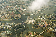
Aerial Photograph - Oct 2013

The Prime Minister's office at Perdana Putra

Perbadanan government complex
The Ministry of Finance complex
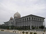
Istana Kehakiman

Putrajaya Walk
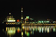
PM Office and Putra Mosque at night
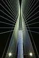
Interior view of the Seri Wawasan Bridge
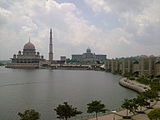
Putra Mosque with the Prime Minister's office in the background
Seri Saujana Bridge at night
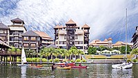
Pullman Putrajaya Lakeside Hotel

Modern architecture includes streetlamps
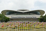
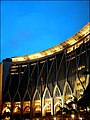
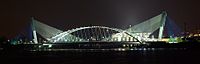
Putrajaya International Convention Centre (PICC)
Ministry of Health Building

Highrises in Precinct 8

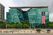
Ministry of Agriculture and Agro Based Industry Building


See also[]
References[]
- Citations
- ^ "Laporan Kiraan Permulaan 2010". Jabatan Perangkaan Malaysia. p. 27. Archived from the original on 8 July 2011. Retrieved 24 January 2011.
- ^ "Malaysia's population stood at 32.6 million in Q4 2018". The Borneo Post. 2018. Retrieved 12 February 2019.
- ^ "Subnational Human Development Index (2.1) [Sabah – Malaysia]". Global Data Lab of Institute for Management Research, Radboud University. Retrieved 12 November 2018.
- ^ "Putrajaya: Malaysia's new federal administrative capital". Cities. 27 (4): 285–297. 1 August 2010. doi:10.1016/j.cities.2009.11.002. ISSN 0264-2751.
- ^ "The journey of Putrajaya — Malaysia's jewel capital city". The Malaysian Reserve. 31 January 2019. Retrieved 19 August 2021.
- ^ "History of Building – CACJ". Retrieved 19 August 2021.
- ^ "The Story of Prang Besar". Retrieved 30 January 2019.
- ^ (in Malay)Abdullah, Hasfiza (February 2012). DARI PRANG BESAR KE PUTRAJAYA. Dewan Bahasa dan Pustaka. Retrieved 26 October 2015.
- ^ "PM isytihar Putrajaya sebagai Wilayah Persekutuan". Utusan Malaysia. 2 February 2001. Archived from the original on 21 August 2018. Retrieved 23 May 2018.
- ^ "Closer ties between Putrajaya and Sejong, Korea". (Archived from the original) The Star (Malaysia). Saturday 6 April 2013. Updated on Friday 26 April 2013. Retrieved on 1 January 2014.
- ^ "Malaysian envoy acclaims Sejong City." (Archive) The Korea Times. 23 September 2012.
- ^ "Population by States and Ethnic Group". Department of Information, Ministry of Communications and Multimedia, Malaysia. 2015. Archived from the original on 12 February 2016. Retrieved 12 February 2015.
- ^ "2010 Population and Housing Census of Malaysia" (PDF) (in Malay and English). Department of Statistics, Malaysia. Archived from the original on 22 May 2014. Retrieved 17 June 2012.CS1 maint: bot: original URL status unknown (link)
- ^ "Putrajaya Botanical Garden (Taman Botani)". Tourism Malaysia. Archived from the original on 25 May 2014. Retrieved 25 May 2014.
- ^ "Heriot-Watt University Malaysia".
- ^ Bhd, Express Rail Link Sdn. "KLIAtransit Schedule - KLIA Ekspres". www.kliaekspres.com. Retrieved 26 March 2017.
- ^ "MYMRT | MRT Corp - Official webpage for the Klang Valley My Rapid Transit". www.mymrt.com.my. Archived from the original on 27 June 2017. Retrieved 26 March 2017.
- ^ "PENGANGKUTAN AWAM PUTRAJAYA SDN BHD". www.papsb.com.my. Retrieved 26 March 2017.
- ^ Yeen, Oh Ing. "Closer ties between Putrajaya and Sejong, Korea - Community | The Star Online". Retrieved 13 February 2017.
- ^ https://en.climate-data.org/asia/malaysia/putrajaya/putrajaya-971597/
- ^ "Climate: Putrajaya". Climate-Data.org. Retrieved 30 July 2020.
- General
- "Putrajaya presentation". Yangsquare.com. Archived from the original on 10 February 2013. Retrieved 22 January 2014.
Further reading[]
- King, Ross: Kuala Lumpur and Putrajaya: Negotiating Urban Space in Malaysia, Nias Press, 2008
External links[]
| Wikimedia Commons has media related to Putrajaya. |
 Putrajaya travel guide from Wikivoyage
- Official website
- Tourism Malaysia – Putrajaya
- Traveller's guide to Putrajaya written and maintained by locals
- State Development Office – State Development Office Wilayah Persekutuan
- How to get to Putrajaya from Kuala Lumpur – KLSentral.info
| show Authority control |
|---|
- Putrajaya
- Federal Territories in Malaysia
- Peninsular Malaysia
- MSC Malaysia
- Planned capitals
- Planned cities in Malaysia
- Suburbs in Kuala Lumpur
- Populated places established in 1995
- 1995 establishments in Malaysia
- Cities in Malaysia