West Island, Cocos (Keeling) Islands
Native name: | |
|---|---|
 Cocos (Keeling) Islands Airport, on West Island | |
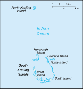 The Cocos (Keeling) Islands, showing West Island | |
 West Island West Island in the Indian Ocean | |
| Geography | |
| Location | Indian Ocean |
| Coordinates | 12°11′13″S 96°49′42″E / 12.18694°S 96.82833°ECoordinates: 12°11′13″S 96°49′42″E / 12.18694°S 96.82833°E |
| Archipelago | Cocos (Keeling) Islands |
| Area | 6.23 km2 (2.41 sq mi) |
| Administration | |
Australia | |
| External territory of Australia | Australian Indian Ocean Territories |
| Territory | Cocos (Keeling) Islands |
| Capital city | Canberra |
| Demographics | |
| Population | 120 |
| Languages | |
| Additional information | |
| Time zone | |

West Island (Malay: Pulau Panjang, Cocos Malay: Pulu Panjang), part of the South Keeling Islands, is the capital of the Cocos (Keeling) Islands, an Australian external territory in the Indian Ocean. The population is roughly 120 making it the third smallest capital in the world, and consists mainly of Europeans. It is less populous than Home Island, the only other inhabited island.
West Island was part of the Clunies-Ross plantation and an airstrip was built here during World War II. As well as all the government buildings, it contains the airport, a general store and tourist accommodation. In November 2013 it was revealed that the Australian Signals Directorate operates a listening station on West Island.[1] Wullenweber and Adcock antenna systems as well as two satellite dish antennae are clearly visible via Google satellite view.
Education[]
Cocos Islands District High School operates a primary and secondary campus on West Island. Most of the students of that campus originate from the Australian continent.[2]
Heritage listings[]
West Island contains a number of heritage-listed sites, including:
- Morea Close: Administration Building Forecourt[3]
- Air Force Road: Direction Island Houses[4]
- Qantas Close: Government House[5]
- Sydney Highway: Qantas Huts[6]
- RAAF Memorial[7]
- Air Force Road: Type 2 Residences[8]
- William Keeling Crescent: Type T Houses Precinct[9]
- Orion Close: West Island Elevated Houses[10]
- Air Force Road: West Island Housing Precinct[11]
- Alexander Street: West Island Mosque[12]
See also[]
References[]
- ^ Dorling, Philip (1 November 2013). "Listening post revealed on Cocos Islands". Canberra Times.
- ^ Home. Cocos Islands District High School. Retrieved on 8 April 2019.
- ^ "Administration Building Forecourt (Place ID 105356)". Australian Heritage Database. Department of the Environment. Retrieved 15 May 2019.
- ^ "Direction Island (DI) Houses (Place ID 105358)". Australian Heritage Database. Department of the Environment. Retrieved 15 May 2019.
- ^ "Government House (Place ID 105360)". Australian Heritage Database. Department of the Environment. Retrieved 15 May 2019.
- ^ "Qantas Huts (former) (Place ID 105354)". Australian Heritage Database. Department of the Environment. Retrieved 15 May 2019.
- ^ "RAAF Memorial (Place ID 105353)". Australian Heritage Database. Department of the Environment. Retrieved 15 May 2019.
- ^ "Type 2 Residences (Place ID 105357)". Australian Heritage Database. Department of the Environment. Retrieved 15 May 2019.
- ^ "Type T Houses Precinct (Place ID 105408)". Australian Heritage Database. Department of the Environment. Retrieved 15 May 2019.
- ^ "West Island Elevated Houses (Place ID 105359)". Australian Heritage Database. Department of the Environment. Retrieved 15 May 2019.
- ^ "West Island Housing Precinct (Place ID 105223)". Australian Heritage Database. Department of the Environment. Retrieved 15 May 2019.
- ^ "West Island Mosque (Place ID 105219)". Australian Heritage Database. Department of the Environment. Retrieved 15 May 2019.
- West Island, Cocos (Keeling) Islands
- Populated places in the Cocos (Keeling) Islands
- Capitals in Asia