Cocos (Keeling) Islands Airport
Cocos (Keeling) Islands Airport Lapangan Terbang Pulu Koko | |||||||||||
|---|---|---|---|---|---|---|---|---|---|---|---|
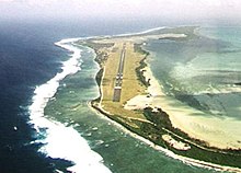 Aerial view in the direction of Runway 33 | |||||||||||
| Summary | |||||||||||
| Airport type | Public | ||||||||||
| Operator | Toll Remote Logistics | ||||||||||
| Location | West Island, Cocos (Keeling) Islands | ||||||||||
| Elevation AMSL | 10 ft / 3 m | ||||||||||
| Coordinates | 12°11′19″S 096°49′50″E / 12.18861°S 96.83056°ECoordinates: 12°11′19″S 096°49′50″E / 12.18861°S 96.83056°E | ||||||||||
| Website | cocosislandairport | ||||||||||
| Map | |||||||||||
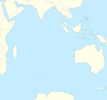 CCK Location on a map of the Indian Ocean | |||||||||||
| Runways | |||||||||||
| |||||||||||
| Statistics (2010/11[a 1]) | |||||||||||
| |||||||||||


Cocos (Keeling) Islands Airport (Cocos Islands Malay: Lapangan Terbang Pulu Koko (Keeling)) (IATA: CCK, ICAO: YPCC) is an airport serving the Cocos (Keeling) Islands, a territory of Australia located in the Indian Ocean. The airport is located on West Island, one of the South Keeling Islands and capital of the territory.
History[]

The airfield was built during World War II to support Allied aircraft in the war against Japan. Two airstrips were built, and three bomber squadrons were moved to the islands to conduct raids against Japanese targets in Southeast Asia and to provide support during the planned re-invasion of Malaya and reconquest of Singapore. The first aircraft to arrive were Supermarine Spitfire Mk VIIIs of No. 136 Squadron RAF.[3] They included some B-24 Liberator bombers from No. 321 (Netherlands) Squadron RAF (members of exiled Dutch forces serving with the Royal Air Force), which were also stationed on the islands.
Facilities[]
The airport has one runway, designated 15/33, with an asphalt surface measuring 2,441 m × 45 m (8,009 ft × 148 ft) and an elevation of 10 ft (3 m) above sea level.[1]
Airlines and destinations[]
| Airlines | Destinations |
|---|---|
| Toll Global Express | Christmas Island, Perth |
| Virgin Australia Regional Airlines | Christmas Island, Perth |
Statistics[]
Cocos Island Airport served 14,896 revenue passengers during financial year 2017–2018.[a 1][2]
| Year[a 1] | Revenue passengers | Aircraft movements |
|---|---|---|
| 2001–02 | 4,740 |
218
|
| 2002–03 | 4,328 |
212
|
| 2003–04 | 4,976 |
218
|
| 2004–05 | 5,631 |
226
|
| 2005–06 | 5,632 |
224
|
| 2006–07 | 6,501 |
232
|
| 2007–08 | 6,510 |
320
|
| 2008–09 | 5,611 |
238
|
| 2009–10 | 9,129 |
302
|
| 2010–11 | 15,712 |
303
|
| 2011–12 | 7,957 |
277
|
| 2012–13 | 14,478 |
454
|
| 2013–14 | 8,664 |
398
|
| 2014–15 | 11,323 |
360
|
| 2015–16 | 17,659 |
308
|
| 2016–17 | 16,387 |
345
|
| 2017–18 | 14,896 |
260
|
See also[]
- List of airports in territories of Australia
- Aviation transport in Australia
References[]
Footnotes[]
- ^ Jump up to: a b c Fiscal year 1 July – 30 June
Notes[]
- ^ Jump up to: a b YPCC – Cocos (Keeling) Island (PDF). AIP En Route Supplement from Airservices Australia, effective 25 Mar 2021, Aeronautical Chart Archived 10 April 2012 at the Wayback Machine
- ^ Jump up to: a b c "Airport Traffic Data 1985–86 to 2010–11". Bureau of Infrastructure, Transport and Regional Economics (BITRE). May 2012. Archived from the original on 24 March 2012. Retrieved 27 June 2012. Refers to "Regular Public Transport (RPT) operations only"
- ^ Fail, J.E.H. "FORWARD STRATEGIC AIR BASE COCOS ISLAND". rquirk.com. Archived from the original on 7 February 2013. Retrieved 13 February 2013.
Further reading[]
- McGrath, Tony (2019). In Tropical Skies: A History of Aviation to Christmas Island and Cocos (Keeling) Islands. Carlisle, WA: Hesperian Press. ISBN 9780859057561.
External links[]
| Wikimedia Commons has media related to Cocos (Keeling) Islands Airport. |
- Cocos Islands Airport: a pictorial history archived version – compiled by Geoff Goodall
- Photos of the Cocos (Keeling) Islands Airport
- Airports in territories of Australia
- Airports in the Cocos (Keeling) Islands