Qala i Naw Airport
Qala i Naw Airport د قلعه نوهوائی ډګر | |||||||||||
|---|---|---|---|---|---|---|---|---|---|---|---|
| Summary | |||||||||||
| Airport type | Public/Military | ||||||||||
| Owner | |||||||||||
| Operator | Afghan National Security Forces (ANSF) ISAF | ||||||||||
| Serves | Qala i Naw, Badghis Province | ||||||||||
| Location | Qala i Naw, Afghanistan | ||||||||||
| Elevation AMSL | 2,968 ft / 905 m | ||||||||||
| Coordinates | 34°59′09″N 63°07′04″E / 34.98583°N 63.11778°ECoordinates: 34°59′09″N 63°07′04″E / 34.98583°N 63.11778°E | ||||||||||
| Map | |||||||||||
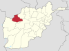
 LQN Location of airport in Afghanistan | |||||||||||
| Runways | |||||||||||
| |||||||||||

Qala i Naw Airport (IATA: LQN, ICAO: OAQN) is a small airport serving the city of Qala i Naw in Badghis Province, Afghanistan.[3] It is also known as Qala Nau Airport.[4] It previously had scheduled services with the now defunct Pamir Airways.[5] This airport is unique in the fact that the runway was originally a highway utilized when there was no air traffic. The runway lies adjacent to the site of a former Spanish forward operating base (FOB), now transferred to the Afghan government. The airport is mainly used for military purposes, including by the Afghan Air Force (AAF). Qala e Naw Airport is located next to Qala i Naw Airport.[6]
See also[]
References[]
- ^ Airport record for Qala-I-Naw Airport at Landings.com. Retrieved 2013-8-1
- ^ AIP Afghanistan - Important Information Archived 2016-06-17 at the Wayback Machine
- ^ Airport information for OAQN at Great Circle Mapper.
- ^ Accident history for LQN at Aviation Safety Network
- ^ "Archived copy". Archived from the original on September 3, 2011. Retrieved October 25, 2011.
{{cite web}}: CS1 maint: archived copy as title (link) - ^ http://af.geoview.info/qalae_naw_airport,22080030p
External links[]
- Airport record for Qala-I-Naw Airport at Landings.com.
Capital: Qala i Naw | ||
| Districts |
|  |
| Populated places in Badghis Province |
| |
| Landmarks | ||
This article about an Afghan airport is a stub. You can help Wikipedia by . |
Categories:
- Airports in Afghanistan
- Badghis Province
- Asian airport stubs
- Afghan building and structure stubs