Quetta
Quetta
| |
|---|---|
 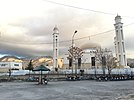   Clockwise from top: Night view of Quetta City, Mehrabad Valley, Cantt Quetta, Bolan Mosque | |
 Emblem | |
| Nickname(s): Little London, Fruit Garden of Pakistan | |
 Quetta | |
| Coordinates: 30°11′N 67°00′E / 30.183°N 67.000°ECoordinates: 30°11′N 67°00′E / 30.183°N 67.000°E | |
| Country | |
| Province | |
| District | Quetta |
| Incorporated | 1876 |
| Government | |
| • Type | Municipal Corporation[1] |
| • Mayor of Quetta | Seat Vacant |
| • Deputy Mayor of Quetta | Seat Vacant |
| Area | |
| • City | 178 km2 (69 sq mi) |
| • Metro | 3,501 km2 (1,352 sq mi) |
| Elevation | 1,680 m (5,510 ft) |
| Population | |
| • City | 1,001,205 |
| • Rank | 10th in Pakistan; 1st in Balochistan |
| • Density | 5,600/km2 (15,000/sq mi) |
| • Demonym | Quettan or Quettawal (kʰwətə.wal) |
| Time zone | UTC+05:00 (PST) |
| ZIP code format | 87xxx |
| Area code(s) | 081 |
| Website | www |


Quetta (/ˈkwɛtə/; Balochi: کویته; Pashto: کوټه; Urdu: کوئٹہ; [ˈkweːʈə] (![]() listen)), formerly known as Shalkot (Balochi: شال کوٹ)[3], is the provincial capital and largest city of the Pakistani province of Balochistan. It is also the 10th largest city in Pakistan.[4] It was largely destroyed in the 1935 Quetta earthquake, but was rebuilt and has a population of 1,001,205 according to the census of 2017.[5][2][6] Quetta is at an average elevation of 1,680 metres (5,510 feet) above sea level,[7] making it Pakistan's only high-altitude major city. The city is known as the "Fruit Garden of Pakistan," due to the numerous fruit orchards in and around it, and the large variety of fruits and dried fruit products produced there.[8]
listen)), formerly known as Shalkot (Balochi: شال کوٹ)[3], is the provincial capital and largest city of the Pakistani province of Balochistan. It is also the 10th largest city in Pakistan.[4] It was largely destroyed in the 1935 Quetta earthquake, but was rebuilt and has a population of 1,001,205 according to the census of 2017.[5][2][6] Quetta is at an average elevation of 1,680 metres (5,510 feet) above sea level,[7] making it Pakistan's only high-altitude major city. The city is known as the "Fruit Garden of Pakistan," due to the numerous fruit orchards in and around it, and the large variety of fruits and dried fruit products produced there.[8]
Located in northern Balochistan near the Pakistan-Afghanistan border and the road across to Kandahar, Quetta is a trade and communication centre between the two countries. The city is near the Bolan Pass route which was once one of the major gateways from Central Asia to South Asia. Quetta played an important role militarily for the Pakistani Armed Forces in the intermittent Afghanistan conflict.
Etymology[]
The name Quetta is a corruption of the Balochi word Kwatkōṭ and it was still known as shol-kot in the British era.[9]
History[]

The immediate area has long been one of pastures and mountains, with varied plants and animals relative to the dry plains to the west.
From 11th century CE, the land of Quetta was owned and ruled by the royal tribe of Pashtuns Kasi. It was captured by Sultan Mahmud Ghaznavi during his invasion of South Asia.[10] In 1543, Mughal emperor Humayun came to Quetta en route to Safavid Persia, leaving his son and future Mughal emperor Akbar here. In 1709, the region was a part of Afghan Hotak dynasty and stayed a part until 1747 when Ahmed Shah Durrani conquered it and made it a part of Durrani Empire. The first European visited Quetta in 1828, describing it as mud-walled fort surrounded by three hundred mud houses.[11]
In 1876 Quetta was occupied by the British and subsequently incorporated into British India.[10] In 1856, British General John Jacob had urged his government to occupy Quetta given its strategic position on the western frontier.[12] British Troops constructed the infrastructure for their establishment. By the time of the earthquake on 31 May 1935, Quetta had developed into a bustling city with a number of multi-storey buildings and so was known as "Little London". The epicenter of the earthquake was close to the city and destroyed most of the city's infrastructure, killing an estimated 40,000 people.[13] The geography of Quetta was known as Al-Qiqan, during the era of Ali ibn Abi Talib, one of the Caliph of Rashidun Caliphate in 660CE. [14]
Geography[]
Climate[]
Quetta has a cold semi-arid climate (Köppen BSk) with a significant variation between summer and winter temperatures. Summer starts about late May and goes on until early September with average temperatures ranging from 24–26 °C (75–79 °F). The highest temperature in Quetta is 42 °C (108 °F) which was recorded on 10 July 1998.[15] Autumn starts in mid-September and continues until mid-November with average temperatures in the 12–18 °C (54–64 °F) range. Winter starts in late November and ends in late February, with average temperatures near 4–5 °C (39–41 °F). The lowest temperature in Quetta is −18.3 °C (−0.9 °F) which was recorded on 8 January 1970.[15] Spring starts in early March and ends in mid-May, with average temperatures close to 15 °C (59 °F). Unlike more easterly parts of Pakistan, Quetta does not have a monsoon season of heavy rainfall. Highest rainfall during 24 hours in Quetta is 113 millimetres (4.4 in) which was recorded on 17 December 2000,[15] Highest monthly rainfall of 232.4 millimetres (9.15 in) was recorded in March 1982, also the year of the highest annual rainfall, at 949.8 millimetres (37.39 in).[15] In the winter, snowfall has become quite erratic (December, January and February).
| hideClimate data for Quetta, Pakistan | |||||||||||||
|---|---|---|---|---|---|---|---|---|---|---|---|---|---|
| Month | Jan | Feb | Mar | Apr | May | Jun | Jul | Aug | Sep | Oct | Nov | Dec | Year |
| Record high °C (°F) | 23.6 (74.5) |
26.7 (80.1) |
31.1 (88.0) |
35.0 (95.0) |
39.4 (102.9) |
41.5 (106.7) |
42.0 (107.6) |
40.6 (105.1) |
38.3 (100.9) |
34.0 (93.2) |
36.0 (96.8) |
25.0 (77.0) |
42.0 (107.6) |
| Average high °C (°F) | 10.8 (51.4) |
12.9 (55.2) |
18.7 (65.7) |
24.8 (76.6) |
30.4 (86.7) |
35.3 (95.5) |
35.9 (96.6) |
34.8 (94.6) |
31.4 (88.5) |
25.5 (77.9) |
19.2 (66.6) |
13.3 (55.9) |
24.4 (75.9) |
| Daily mean °C (°F) | 3.7 (38.7) |
6.0 (42.8) |
11.1 (52.0) |
16.6 (61.9) |
21.0 (69.8) |
25.6 (78.1) |
27.9 (82.2) |
26.4 (79.5) |
21.1 (70.0) |
14.6 (58.3) |
9.2 (48.6) |
5.1 (41.2) |
15.7 (60.3) |
| Average low °C (°F) | −3.4 (25.9) |
−0.9 (30.4) |
3.4 (38.1) |
8.3 (46.9) |
11.5 (52.7) |
15.9 (60.6) |
19.9 (67.8) |
17.9 (64.2) |
10.9 (51.6) |
3.8 (38.8) |
−0.9 (30.4) |
−3.2 (26.2) |
6.9 (44.5) |
| Record low °C (°F) | −18.3 (−0.9) |
−16.7 (1.9) |
−8.3 (17.1) |
−3.9 (25.0) |
−0.3 (31.5) |
5.0 (41.0) |
8.9 (48.0) |
3.3 (37.9) |
−0.6 (30.9) |
−8.3 (17.1) |
−13.3 (8.1) |
−18.3 (−0.9) |
−18.3 (−0.9) |
| Average precipitation mm (inches) | 56.7 (2.23) |
49 (1.9) |
55 (2.2) |
28.3 (1.11) |
6 (0.2) |
1.1 (0.04) |
12.7 (0.50) |
12.1 (0.48) |
0.3 (0.01) |
3.9 (0.15) |
5.3 (0.21) |
30.5 (1.20) |
260.9 (10.23) |
| Average snowfall cm (inches) | 22 (8.7) |
17 (6.6) |
3.0 (1.2) |
0 (0) |
0 (0) |
0 (0) |
0 (0) |
0 (0) |
0 (0) |
0 (0) |
0.51 (0.2) |
14 (5.4) |
56.51 (22.1) |
| Mean monthly sunshine hours | 220.1 | 209.05 | 232.5 | 273 | 334.8 | 327 | 313.1 | 313.1 | 294 | 306.9 | 279 | 238.7 | 3,341.25 |
| Source 1: Hong Kong Observatory (altitude: 1589 m)[16] | |||||||||||||
| Source 2: PMD[17] | |||||||||||||
The city saw a severe drought from 1999 to 2001, during which the city did not receive snowfall and below normal rains. In 2002 the city received snow after a gap of five years. In 2004 and 2005, the city received normal rains after three years without snowfall while in 2006, 2007 and 2009 the city received no snow. In 2008 Quetta received a snowfall of 10 centimetres (4 in) in four hours on 29 January,[18] followed on 2 February by 25.4 centimetres (10 in) in 10 hours[19] – the city's heaviest snowfall in a decade. During the winter of 2010 it received no snow and saw below normal rains due to the presence of El-Nino over Pakistan.[citation needed]
Demographics[]
| Year | Pop. | ±% |
|---|---|---|
| 1941 | 65,000 | — |
| 1951 | 84,000 | +29.2% |
| 1961 | 107,000 | +27.4% |
| 1972 | 158,000 | +47.7% |
| 1981 | 286,000 | +81.0% |
| 1998 | 565,137 | +97.6% |
| 2017 | 1,001,205 | +77.2% |
| Source: [20][2] | ||
The population of the city is around one million. In 2016, it was estimated at 1,140,000,[21] but the 2017 Census revealed a total of 1,001,205. This makes it the largest city in Balochistan province and one of the major cities of Pakistan. The scholars disagree about the demographics of the city. According to some, the city has a Pashtun plurality followed by Baloch people, other indigenous people of Balochistan, Hazaras and lastly the settlers from other areas of Pakistan.[22] Others think the city has a Pashtun majority followed by Balochs, Hazaras, Brahui, Punjabis and Muhajir people.[23][24][25] Urdu being national language is used and understood by all the residents and serves as a lingua franca.
According to Reuters and the BBC, there are as many as 500,000-600,000 Hazaras living in Quetta and its surrounding areas.[26][27]
Administration[]
At the local level, the city is governed by a municipal corporation consisting of 66 ward members which elects a mayor and a deputy mayor.[1] In addition, Quetta development authority is responsible for provision of municipal services for the city.[28]
Transportation[]
Quetta is on the western side of Pakistan and is connected to the rest of the country by a network of roads, railways and its international airport close to its center.
At an altitude of 1,605 metres (5,266 feet) above sea level, Quetta Airport is the second highest airport in Pakistan.[29] Pakistan International Airlines has regular flights to and from the other major cities of Pakistan including Islamabad, Gwadar, Karachi, Lahore and Peshawar.

Quetta Railway Station is one of the highest railway stations in Pakistan at 1,676 metres (5,499 feet) above sea level. The railway track was laid in the 1890s during the British era to link Quetta with rest of the country. The extensive network of Pakistan Railways connects Quetta to Karachi in the south, by a 863 km (536 mi) track, Lahore in the northeast (1,170 km or 727 miles) and Peshawar further northeast (1,587 km or 986 miles). A metalled road runs alongside the railway that connects Quetta to Karachi via the nearby town of Sibi to Jacobabad and Rohri in the plain of the River Indus.[30]
Education[]
Quetta serves as the learning centre for the Balochistan province. The city has a number of government and private colleges, including the following:
- University of Balochistan
- Balochistan University of Information Technology, Engineering and Management Sciences (BUITEMS)
- Sardar Bahadur Khan Women's University
- Islamia High School: It was frequently visited by Quaid-e-Azam in 1937 and was nicknamed as Chhota Aligarh (Little Aligarh) by him[31]
- St. Joseph's Convent School, Quetta
- Bolan Medical College
- University Law College (ULC)
- Balochistan Agriculture College
- Geological Survey of Pakistan
- Tameer-e-Nau Public College
- St Francis Grammar School
- Command and Staff College
- Science College
- School of Infantry and Tactics
- Quetta Institute of Medical Sciences
Sports[]
Cricket and football are the two most popular sports among the people of Quetta. Football teams from Quetta include Quetta Zorawar, Muslim FC, Hazara Green Football Club, Baluch Football Club and Quetta Bazigars Club, and Balochistan United W.F.C. won the 2014 National Women Championship. The Bugti Stadium is the home of Balochistan cricket team, a first-class cricket team which competes in domestic tournaments,[32] while the city based Quetta Gladiators compete in the Pakistan Super League (PSL).
Boxing is highly popular as well.[33] Muhammad Waseem is a professional boxer from Quetta. In Body Building Nisar Ahmed Khilji have Mr. Balochistan and Mr. Pakistan Titles and Pakistan representation in International Body Building Contests. In hockey, Quetta has produced Zeeshan Ashraf and Shakeel Abbasi, who were members of the Pakistan's national hockey team.

Facilities[]
The Shaheed Nauoroz Stadium is the largest stadium in the city. The city also has Ayub National Stadium, a multipurpose stadium used for football and cricket and Bugti Stadium for cricket.
Local facilities were created in the city for mountain climbing and caving as well as water sports. Hayatullah Khan Durrani (Pride of Performance) is the chief executive of Hayat Durrani Water Sports Academy, Balochistan's first and only Rowing, Canoeing, Kayaking, Sailing, rough swimming and boating academy where all such facilities provide free to the youth members at Hanna Lake. In kayaking, Muhammad Abubakar Durrani, National Junior Champion was selected for the world Junior Canoeing Championship in 2009 in Moscow.[34][35]
See also[]
- 2008 Ziarat earthquake
- List of people from Quetta
- Pashtun cuisine
- Quetta hut
References[]
- ^ Jump up to: a b "Government Organization – Government of Balochistan". balochistan.gov.pk. Retrieved 6 September 2016.
- ^ Jump up to: a b c DISTRICT WISE CENSUS RESULTS CENSUS 2017 (PDF) (Report). Pakistan Bureau of Statistics. 2017. p. 13. Archived from the original (PDF) on 29 August 2017. Retrieved 29 March 2018.
- ^ Thornton, TH. "Colonel Sir Robert Sandeman: His Life and Work on Our Indian Frontier. A Memoir, with Selections from His Correspondence and Official Writings". Pg. 211. University of California. J. Murray, 1895.
- ^ "POPULATION SIZE AND GROWTH OF MAJOR CITIES" (PDF).
- ^ "PROVISIONAL SUMMARY RESULTS OF 6TH POPULATION AND HOUSING CENSUS-2017 | Pakistan Bureau of Statistics". www.pbs.gov.pk. Retrieved 16 May 2019.
- ^ "DISTRICT WISE CENSUS RESULTS CENSUS 2017" (PDF). pbscensus.gov.pk. Archived from the original (PDF) on 29 August 2017.
- ^ "Mongabay -environmental science and conservation news". Archived from the original on 4 March 2016.
- ^ "The Fruit Garden of Pakistan – Quetta". asadasif.com. 4 February 2008. Retrieved 10 January 2017.
- ^ Baloch, Hameed (2008). The Balochistan Chronicles: The Archives of the Times, London and the New York Times on Balochistan, from 1842-2007. Sayad Hashmi Reference Library. p. 361.
- ^ Jump up to: a b Burki, Shahid Javed (2015). Historical Dictionary of Pakistan. Rowman & Littlefield. ISBN 9781442241480.
- ^ BHC. "History of District". bhc.gov.pk. Retrieved 26 November 2017.
- ^ Dodwell, H. H. (1929). The Cambridge History of the British Empire. CUP Archive.
- ^ ڈان اردو (30 December 2013). "پاکستانی شہروں کی تاریخ". dawnnews.tv. Retrieved 26 February 2016.
- ^ Ibn Sa'd, 8:346. The raid is noted by Baâdhurî, "fatooh al-Baldan" p. 432, and Ibn Khayyât, Ta'rîkh, 1:173, 183–84, as cited in: Derryl N. Maclean," Religion and Society in Arab Sind", p. 126, BRILL, (1989) ISBN 90-04-08551-3.
- ^ Jump up to: a b c d [1] Archived 13 June 2010 at the Wayback Machine
- ^ "Climatological Information for Quetta, Pakistan". Hong Kong Observatory. Archived from the original on 16 June 2018. Retrieved 3 December 2019.
- ^ "Extremes of Quetta". Pakistan Meteorological Department. Retrieved 3 February 2015.
- ^ [2] Archived 4 January 2009 at the Wayback Machine
- ^ "Leading News Resource of Pakistan". Daily Times. 4 February 2008. Retrieved 8 May 2012.
- ^ Elahi, Asad (2006). "2: Population" (PDF). Pakistan Statistical Pocket Book 2006. Islamabad, Pakistan: Government of Pakistan: Statistics Division. p. 28. Retrieved 29 March 2018.
- ^ "Demographics" (PDF). www.demographia.com. Retrieved 16 March 2020.
- ^ Jonah Blank, Christopher Clary & Brian Nichiporuk 2014.
- ^ Sarina Singh (2008). Pakistan & the Karakoram Highway. Lonely Planet. p. 142. ISBN 978-1-74104-542-0.
- ^ "The Crowded-Out Conflict by Ann Wilkens – Pashtun form the Majority".
- ^ Abubakar Siddique (2014). The Pashtun Question: The Unresolved Key to the Future of Pakistan and Afghanistan. Hurst. p. 22. ISBN 978-1-84904-292-5.
- ^ "Two killed in sectarian attack in southwestern Pakistan". Reuters. 22 April 2018.
- ^ Kermani, Secunder (12 December 2017). "The community caged in its own city". BBC News.
- ^ https://qda.gob.pk/index.php/about-us/about-qda
- ^ Quetta Airport Archived 29 June 2009 at the Wayback Machine CAA Pakistan. Retrieved 24 June 2009
- ^ "Bomb attack targets Worshippers at Quetta mosque, killing 14". www.aljazeera.com.
- ^ Dr. Javed Haider Sayed (2008). "The Balochistan Muslim League". National Institute of Historical & Cultural Research – Pakistan. Quaid-e-Azam University, Islamabad. Retrieved 6 March 2016.[permanent dead link]
- ^ "PCB unveils new domestic set-up with 'stay at the top' mantra". ESPN Cricinfo.
- ^ Faruqi, Sama. "The Hazaras who made Quetta a boxing powerhouse". The Caravan. Retrieved 7 December 2019.
- ^ Pakistan Players for Moscow Archived 24 January 2013 at archive.today
- ^ "GEO TV Report Pakistan Players for Moscow >". Geo.tv. 28 July 2009. Archived from the original on 13 June 2010. Retrieved 21 January 2014.
Bibliography[]
- Bosworth, C.E. (1986). "Kwat́́t́́a". In Bosworth, C. E.; van Donzel, E.; Lewis, B. & Pellat, Ch. (eds.). The Encyclopaedia of Islam, New Edition, Volume V: Khe–Mahi. Leiden: E. J. Brill. ISBN 978-90-04-07819-2.
- Jonah Blank; Christopher Clary; Brian Nichiporuk (30 October 2014), Drivers of Long-Term insecurity and Instability in Pakistan: Urbanization, Rand Corporation, p. 29, ISBN 978-0-83-308751-5
External links[]
| Wikimedia Commons has media related to Quetta. |
- Balochistan Board Archived 22 January 2015 at the Wayback Machine
- Official webpage on Balochistan.gov.pk

| hide | ||
|---|---|---|
Provincial capital: Quetta | ||
| Kalat |  | |
| Makran | ||
| Nasirabad | ||
| Quetta |
| |
| Sibi | ||
| Zhob |
| |
| Rakhshan | ||
| Loralai | ||
a - formerly part of Quetta Division; b - formerly part of Kalat Division; c - formerly part of Zhob Division | ||
Largest cities or towns in Balochistan, Pakistan
| |||||||||
|---|---|---|---|---|---|---|---|---|---|
| Rank | Name | District | Pop. | ||||||
 Quetta  Turbat |
1 | Quetta | Quetta District | 1,001,205 |  Khuzdar  Hub | ||||
| 2 | Turbat | Kech District | 213,557 | ||||||
| 3 | Khuzdar | Khuzdar District | 182,927 | ||||||
| 4 | Hub | Lasbela District | 175,376 | ||||||
| 5 | Chaman | Chaman District | 123,191 | ||||||
| 6 | Dera Murad Jamali | Nasirabad District | 96,591 | ||||||
| 7 | Gwadar | Gwadar District | 90,762 | ||||||
| 8 | Dera Allah Yar | Jafarabad District | 80,908 | ||||||
| 9 | Usta Mohammad | Jafarabad District | 77,097 | ||||||
| 10 | Sui Town | Dera Bugti District | 71,676 | ||||||
| show Authority control |
|---|
- Quetta
- Capitals of Pakistan
- Cities destroyed by earthquakes
- Populated places in Balochistan, Pakistan
- Metropolitan areas of Pakistan
- Quetta District