Muzaffarabad
Muzaffarabad
مُظفّر آباد | |
|---|---|
 Aerial view of Muzaffarabad, which is situated in a valley formed by the confluence of the Neelam and Jhelum rivers | |
 Muzaffarabad | |
| Coordinates: 34°21′30″N 73°28′20″E / 34.35833°N 73.47222°ECoordinates: 34°21′30″N 73°28′20″E / 34.35833°N 73.47222°E | |
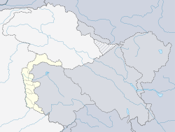
| Country | Pakistan |
| Territory | Azad Kashmir |
| District | Muzaffarabad |
| Founded by | Sultan Muzaffar Khan |
| Elevation | 737 m (2,418 ft) |
| Population | |
| • City | 149,913 |
| • Rank | 60th, Pakistan |
| Languages | |
| • Official | Urdu[2][3][note 1] |
| • Spoken | |
| Time zone | UTC+05:00 (PST) |
| Calling code | 05822 |
| Website | Muzaffarabad Government Portal (defunct) |


Muzaffarabad (/ˌmʊzəˌfærəˈbæd/;[4] Urdu: مُظفّر آباد) is the capital and largest city of Azad Kashmir, and the 60th largest in Pakistan.
The city is located in Muzaffarabad District, near the confluence of the Jhelum and Neelum rivers. The district is bounded by the Pakistani province of Khyber Pakhtunkhwa in the west, the Kupwara and Baramulla districts of Indian-administered Jammu and Kashmir in the east, and the Neelum District in the north.
History
Muzaffarabad was founded in 1646 by Sultan Muzaffar Khan, chief of the Bomba tribe[5] who ruled Kashmir.[6] Khan also constructed the Red Fort that same year for the purpose of warding off incursions from the Mughal Empire.
2005 earthquake
The city was near the epicenter of the 2005 Kashmir earthquake, which had a magnitude of 7.6 Mw. The earthquake destroyed about 50% of the buildings in the city (including most government buildings) and is estimated to have killed up to 80,000 people in the Pakistani-controlled areas. As of 8 October 2005, the Pakistani government's official death toll was 87,350, while other estimates have put the death toll at over 100,000.[7]
Administrative subdivisions

The district of Muzaffarabad is administratively divided into 2 tehsils, which are subdivided into 25 union councils.[8]
- Muzaffarabad
- Pattika (Naseerabad)
Climate
| hideClimate data for Muzaffarabad (1961–2009) | |||||||||||||
|---|---|---|---|---|---|---|---|---|---|---|---|---|---|
| Month | Jan | Feb | Mar | Apr | May | Jun | Jul | Aug | Sep | Oct | Nov | Dec | Year |
| Record high °C (°F) | 27.0 (80.6) |
29.4 (84.9) |
37.0 (98.6) |
40.5 (104.9) |
46.5 (115.7) |
46.2 (115.2) |
45.0 (113.0) |
40.2 (104.4) |
39.0 (102.2) |
38.3 (100.9) |
33.0 (91.4) |
27.0 (80.6) |
46.5 (115.7) |
| Average high °C (°F) | 16.0 (60.8) |
18.0 (64.4) |
22.6 (72.7) |
28.3 (82.9) |
33.5 (92.3) |
37.4 (99.3) |
34.9 (94.8) |
34.0 (93.2) |
33.4 (92.1) |
30.1 (86.2) |
24.2 (75.6) |
18.1 (64.6) |
22.3 (72.1) |
| Average low °C (°F) | 3.1 (37.6) |
5.4 (41.7) |
9.7 (49.5) |
14.2 (57.6) |
18.4 (65.1) |
21.9 (71.4) |
22.8 (73.0) |
22.6 (72.7) |
19.4 (66.9) |
13.7 (56.7) |
7.8 (46.0) |
4.1 (39.4) |
11.1 (52.0) |
| Record low °C (°F) | −3.0 (26.6) |
−1.1 (30.0) |
1.0 (33.8) |
6.5 (43.7) |
7.0 (44.6) |
12.0 (53.6) |
15.5 (59.9) |
16.0 (60.8) |
12.4 (54.3) |
6.5 (43.7) |
1.0 (33.8) |
−1.4 (29.5) |
−3 (27) |
| Average rainfall mm (inches) | 101.3 (3.99) |
137.4 (5.41) |
157.3 (6.19) |
109.0 (4.29) |
78.5 (3.09) |
113.6 (4.47) |
328.7 (12.94) |
229.9 (9.05) |
112.6 (4.43) |
45.9 (1.81) |
37.2 (1.46) |
69.0 (2.72) |
1,242.8 (48.93) |
| Average relative humidity (%) (at 12:00 PST) | 50.3 | 46.3 | 40.9 | 38.0 | 33.2 | 34.0 | 52.2 | 57.6 | 48.1 | 42.4 | 48.4 | 54.0 | 37.2 |
| Source: Pakistan Meteorological Department[9] | |||||||||||||
Transport
This section needs expansion. You can help by . (June 2020) |
The nearest railway station is located in the Rawalpindi District of Pakistani Punjab.[10]
Notable people
- Anam Najam, medical doctor and psychiatrist
Gallery

Heightened view of the city on both riverbanks after the 2005 Kashmir earthquake, c. 2014
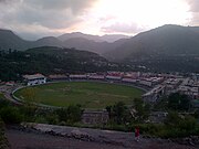
Photo of Muzaffarabad Cricket Stadium
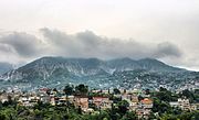
Photo of the city's skyline, c. 2017
Photo of Muzaffarabad Cricket Stadium


See also
Notes
- ^ Snedden (2013, p. 176): On p. 29, the census report states that Urdu is the official language of the government of Azad Kashmir, with Kashmiri, Pahari, Gojri, Punjabi, Kohistani, Pushto, and Sheena 'frequently spoken in Azad Kashmir'. Yet, when surveyed about their 'mother tongue', Azad Kashmiris' choices were limited to selecting from Pakistan's major languages: Urdu, Punjabi, Sindhi, Pushto, Balochi, Saraiki, and 'others'; not surprisingly, 2.18 million of Azad Kashmir's 2.97 million people chose 'others'.
References
- ^ "Statistical Year Book 2019" (PDF). Statistics Azad Jammu and Kashmir. Retrieved 20 April 2020.
- ^ "Kashmir".
- ^ Rahman 1996, p. 226.
- ^ "Muzaffarabad". Lexico UK Dictionary. Oxford University Press.
- ^ Mir-át-i Mas'údi Archived 2007-09-29 at the Wayback Machine
- ^ Ahmad, Pirzada Irshad (2003). A Hand Book on Azad Jammu & Kashmir. Nawab Sons Publication. ISBN 978-969-530-050-3.
- ^ Stuart, Julia. (1 January 2006) IoS Appeal: Last chance to donate to quake victims Archived 16 January 2006 at the Wayback Machine. News.independent.co.uk. Retrieved on 3 July 2012.
- ^ Information about SPs District Muzaffarabad Archived 6 November 2007 at the Wayback Machine
- ^ "Muzaffarabad Climate Data". Pakistan Meteorological Department. Archived from the original on 13 June 2010. Retrieved 1 October 2019.
- ^ Google Maps. Maps.google.co.uk. Retrieved on 3 July 2012.
External links
| Wikivoyage has a travel guide for Muzaffarabad. |
| Wikimedia Commons has media related to Muzaffarabad. |
| show |
|---|
| show |
|---|
| show Authority control |
|---|
- Muzaffarabad
- Capitals of Pakistan
- Tehsils of Muzaffarabad District
- Hill stations in Pakistan
- Kabul Shahi
- Kashmir
- 2005 Kashmir earthquake
- Populated places established in 1646