Kupwara district
Kupwara district
Kopwor | |
|---|---|
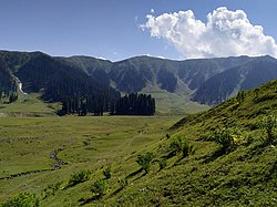 Bangus Valley in Kupwara | |
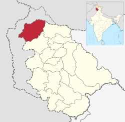 Kupwara district in Jammu and Kashmir | |
| Country | |
| Union Territory | |
| Division | Kashmir Division |
| Headquarters | Kupwara |
| Government | |
| • Lok Sabha Constituency | Baramulla |
| • MP[7] | Mohammad Akbar Lone, JKNC |
| • Vidhan Sabha Constituencies | 5 : Karnah, Kupwara, Lolab, Handwara and Langate |
| Area | |
| • Total | 2,379 km2 (919 sq mi) |
| • Urban | 47.3 km2 (18.3 sq mi) |
| • Rural | 2,331.7 km2 (900.3 sq mi) |
| Population | |
| • Total | 870,354 |
| • Density | 370/km2 (950/sq mi) |
| • Urban | 104,729 |
| • Rural | 765,625 |
| Demographics | |
| • Literacy[4] | 64.51% |
| • Sex ratio[4] | 835 ♀/ 1000 ♂ |
| Languages | |
| • Official | Kashmiri, Urdu, Hindi, Dogri, English |
| Time zone | UTC+05:30 (IST) |
| Vehicle registration | JK-09 |
| Major highways | |
| Website | kupwara |
Kupwara district is one of the 10 districts located in the Kashmir Valley region of Jammu and Kashmir, India. The river Kishenganga, originating from the Himalayas, flows through the outer areas of the district from east to west.[8]
History[]
The district was carved out of the erstwhile Baramulla district in 1979 with Kupwara as the district headquarters.[9]
Geography[]
Kupwara district has a total area of 2,379 square kilometres (919 sq mi). The district is bordered by Bandipora district in the east, Baramulla district to the south and Pakistan administered Jammu and Kashmir to the north and west. The district is mostly rural/agricultural.
Adjacent districts[]
- Bandipora district - east
- Neelum district, Pakistan administered Jammu and Kashmir - northeast
- Neelum district, Pakistan administered Jammu and Kashmir - northwest
- Muzaffarabad district and Hattian Bala district, Pakistan administered Jammu and Kashmir - west
- Baramulla district - south
Economy[]
Most of the people depend on agriculture and horticulture. There is a good production and business of walnuts in Kupwara.[10]
Department of horticulture have developed high density walnut nursery in Kupwara[11]
Demographics[]
| Year | Pop. | ±% p.a. |
|---|---|---|
| 1901 | 110,979 | — |
| 1911 | 124,744 | +1.18% |
| 1921 | 137,936 | +1.01% |
| 1931 | 153,758 | +1.09% |
| 1941 | 170,079 | +1.01% |
| 1951 | 187,076 | +0.96% |
| 1961 | 204,073 | +0.87% |
| 1971 | 257,824 | +2.37% |
| 1981 | 328,743 | +2.46% |
| 1991 | 465,948 | +3.55% |
| 2001 | 650,393 | +3.39% |
| 2011 | 870,354 | +2.96% |
| source:[13] | ||
According to the 2011 census Kupwara district has a population of 870,354.[2] This gives it a ranking of 470th in India (out of a total of 640). The district has a population density of 368 inhabitants per square kilometre (950/sq mi). Its population growth rate over the decade 2001–2011 was 34.62%. Kupwara has a sex ratio of 843 females for every 1000 males (this varies with religion), and a literacy rate of 75.60%.[citation needed]
| showKupwara district: religion, gender ratio, and % urban of population, according to the 2011 Census.[3] |
|---|
At the time of the 2011 census, 71.11% of the population spoke Kashmiri, 14.12% Pahari, 9.21% Gujari and 2.72% Hindi as their first language.[2]
Transportation[]
Air[]
The nearest airport is Sheikh ul-Alam International Airport in Srinagar located 102 kilometres from district headquarters Kupwara. There are plans to construct an airport in Panzgam.[14]
Rail[]
Kupwara district is not yet connected to railways. There are plans to extend the Jammu–Baramulla line up to Kupwara in the near future.[15] The nearest railway station is Baramulla railway station located 45 kilometres from Kupwara.
Road[]
Kupwara is well-connected with roads and highways. The NH 701 passes through Kupwara district alongside other intra-district roads.
Sports[]
Notable Athletes[]
See also[]
References[]
- ^ District Census Handbook Kupwara, Part A (PDF). Census of India 2011 (Report). July 2016. p. 7. Retrieved 21 November 2020.
District Census Handbook Kupwara, Part B (PDF). Census of India 2011 (Report). 16 June 2014. pp. 11, 12. Retrieved 21 November 2020. - ^ Jump up to: a b c d C-16 Population By Mother Tongue – Jammu & Kashmir (Report). Office of the Registrar General & Census Commissioner, India. Retrieved 18 July 2020.
- ^ Jump up to: a b c C-1 Population By Religious Community – Jammu & Kashmir (Report). Office of the Registrar General & Census Commissioner, India. Retrieved 28 July 2020.
- ^ Jump up to: a b "Kupwara district Census 2011" (PDF). Govt of India Census. Retrieved 12 July 2021.
- ^ "The Jammu and Kashmir Official Languages Act, 2020" (PDF). The Gazette of India. 27 September 2020. Retrieved 27 September 2020.
- ^ "Parliament passes JK Official Languages Bill, 2020". Rising Kashmir. 23 September 2020. Retrieved 23 September 2020.
- ^ "Lok Sabha Members". Lok Sabha. Retrieved 12 July 2021.
- ^ "Statement showing the number of blocks in respect of 22 Districts of Jammu and Kashmir State including newly created districts, as on 31-03-2008" (PDF). Archived from the original (PDF) on 10 September 2008. Retrieved 29 August 2008. dated 2008-03-13, accessed 2008-08-30
- ^ "Kupwara: Brief History, Places of Attraction". The Dispatch. Retrieved 12 July 2021.
- ^ Ministry of Panchayati Raj (8 September 2009). "A Note on the Backward Regions Grant Fund Programme" (PDF). National Institute of Rural Development. Archived from the original (PDF) on 5 April 2012. Retrieved 27 September 2011.
- ^ "Horticulture deptt to develop high density walnut nursery in Kupwara". Greater Kashmir. 20 April 2019. Retrieved 16 April 2020.
- ^ "Kupwara district Population". Census India. Retrieved 12 July 2021.
- ^ Decadal Variation In Population Since 1901
- ^ "Centre plans to build 11 new airports in J&K, 2 in Ladakh". Kashmir Life. Retrieved 17 March 2020.
- ^ "J&K gets ₹3,848-cr Baramulla-Kupwara railroad project". NBMCW. Retrieved 12 July 2021.
External links[]
| Wikimedia Commons has media related to Kupwara district. |
Coordinates: 34°31′12″N 74°15′00″E / 34.52000°N 74.25000°E


| show Places adjacent to Kupwara district |
|---|
| show Authority control |
|---|
- Kupwara district
- Districts of Jammu and Kashmir
- Minority Concentrated Districts in India