R573 road (Ireland)
 | ||||
|---|---|---|---|---|
| Bóthar R573 | ||||
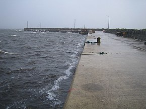 Bunaw Quay, Co. Kerry, on the R573 | ||||
| Route information | ||||
| Length | 11.0 km[1][2] (6.8 mi) | |||
| Major junctions | ||||
| From | ||||
| To | ||||
| Highway system | ||||
| ||||
The R573 road is a regional road in Ireland. It is a coastal loop road from the R571 on the Beara Peninsula in County Kerry.[1][3] Part of the road is on the Wild Atlantic Way.[4]
The R573 travels west from the R571 via Tuosist. The road continues along the coast, via Bunaw Quay and Derreen Garden to rejoin the R571 at . The R573 is 11.0 km (6.8 mi) long.[1][2]
References[]
- ^ a b c Google (7 July 2016). "R571 to R571" (Map). Google Maps. Google. Retrieved 7 July 2016.
- ^ a b "S.I. No. 54/2012 – Roads Act 1993 (Classification of Regional Roads) Order 2012". Government of Ireland. 28 February 2012. Retrieved 7 July 2016.
- ^ Davenport, Fionn; Dixon, Belinda; Le Nevez, Catherine; O'Carroll, Oda (February 2013). Lonely Planet Ireland's Best Trips. Lonely Planet. p. 212. ISBN 978-1-7432-1779-5. Retrieved 7 July 2016.
- ^ "Wild Atlantic Way: Explore The Route". Fáilte Ireland. Retrieved 7 July 2016.
This article related to the geography of County Kerry, Ireland is a stub. You can help Wikipedia by . |
This Irish road or road transport-related article is a stub. You can help Wikipedia by . |
Categories:
- Regional roads in the Republic of Ireland
- Roads in County Kerry
- County Kerry geography stubs
- Ireland road stubs