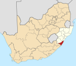
Ramsgate, KwaZulu-Natal
This article needs additional citations for verification. (April 2007) |
Ramsgate | |
|---|---|
 Ramsgate Main Beach | |
 Ramsgate | |
| Coordinates: 30°52′56″S 30°21′20″E / 30.88222°S 30.35556°ECoordinates: 30°52′56″S 30°21′20″E / 30.88222°S 30.35556°E | |
| Country | South Africa |
| Province | KwaZulu-Natal |
| District | Ugu |
| Municipality | Ray Nkonyeni |
| Main Place | Margate |
| Area | |
| • Total | 0.83 km2 (0.32 sq mi) |
| Population (2011)[1] | |
| • Total | 1,080 |
| • Density | 1,300/km2 (3,400/sq mi) |
| Racial makeup (2011) | |
| • Black African | 41.7% |
| • Coloured | 1.9% |
| • Indian/Asian | 2.0% |
| • White | 54.0% |
| • Other | 0.4% |
| First languages (2011) | |
| • English | 46.0% |
| • Afrikaans | 20.6% |
| • Zulu | 16.8% |
| • Xhosa | 13.3% |
| • Other | 3.3% |
| Time zone | UTC+2 (SAST) |
| PO box | 4275 |
| Area code | 039 |
| Website | ramsgatevillage |
Ramsgate is a village on the south coast of KwaZulu-Natal in South Africa, just southwest of Margate. Ramsgate is located on the mouth of a river known by the Zulu name Bilanhlolo ("the marvellous boiler") for the bubbles caused by strong currents making it look like the water is boiling.[citation needed] In 1922, the only person living there was a romantic character called Paul Buck, a painter and violin maker who called the place Blue Lagoon.[citation needed] The most popular restaurant in Ramsgate is the Waffle House which is located near the Blue Lagoon.[1]
References[]
- ^ Jump up to: a b c d "Sub Place Ramsgate". Census 2011.
Categories:
- Populated places in the Ray Nkonyeni Local Municipality
- Populated coastal places in South Africa
- KwaZulu-Natal geography stubs


