Umzumbe
Umzumbe | |
|---|---|
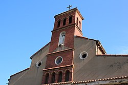
 Old St Elmos church in Umzumbe | |
 | |
| Coordinates: 30°37′30″S 30°32′31″E / 30.6249°S 30.5420°ECoordinates: 30°37′30″S 30°32′31″E / 30.6249°S 30.5420°E | |
| Country | South Africa |
| Province | KwaZulu-Natal |
| District | Ugu |
| Municipality | Ray Nkonyeni |
| Main Place | Hibberdene |
| Area | |
| • Total | 2.21 km2 (0.85 sq mi) |
| Population (2011)[1] | |
| • Total | 366 |
| • Density | 170/km2 (430/sq mi) |
| Racial makeup (2011) | |
| • Black African | 40.2% |
| • Coloured | 4.9% |
| • Indian/Asian | 6.0% |
| • White | 48.6% |
| • Other | 0.3% |
| First languages (2011) | |
| • English | 42.2% |
| • Zulu | 32.4% |
| • Afrikaans | 22.0% |
| • Xhosa | 2.0% |
| • Other | 1.4% |
| Time zone | UTC+2 (SAST) |
| Postal code (street) | 4225 |
| PO box | 4225 |
| Area code | 039 |
Umzumbe is a seaside resort situated at the mouth of the (bad kraal) in KwaZulu-Natal, South Africa. The name of the river is derived from a band of Hlongwa cannibals who occupied the valley. The Hlongwa was almost wiped out by the Zulu king Shaka in 1828.
Etymology[]
Umzumbe is situated south of the mouth of the , from which it takes its name; of Zulu origin, it has been explained as meaning ‘the dangerous river’, ‘the winding river’ and ‘wild bean river’. The form uMzumbe has been approved.[2]
Geography[]
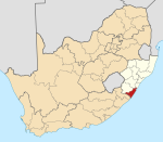
Umzumbe lies on the mouth of the Mzumbe River some 5 km south-west of Hibberdene and lies just north of the small seaside village of Pumula. Furthermore it lies 16 km north of Port Shepstone, the administrative centre of the KwaZulu-Natal South Coast and 98 km south-west of the city of Durban.[3][4]
It lies on the R102 to Hibberdene and Durban to the north and Port Shepstone to the south.
Recreational areas[]
Umzumbe has one beach, the Umzumbe Beach which is a Blue Flag Beach. Nearby and larger beaches within the Lower South Coast include Hibberdene, Ramsgate, St Michael's, Uvongo, Margate and Marina Beach.[5][6]
Another recreational area is the Umzumbe Surf Camp.[7]
Spearfishing[]
Spearfishing is popular in Umzumbe as the Umzumbe point is the most prominent tip south of Hibberdene. It is a prime area for garrick and brusher.[8]
References[]
- ^ a b c d "Sub Place Umzumbe". Census 2011.
- ^ "Dictionary of Southern African Place Names (Public Domain)". Human Science Research Council. p. 447.
- ^ "Travel South Africa". distancecalculator.co.za. Retrieved 2020-07-26.
- ^ "Distance Umzumbe, Ugu, Kwazulu-Natal, ZAF > Port-Shepstone, Ugu, Kwazulu-Natal, ZAF - Air line, driving route, midpoint". www.distance.to. Retrieved 2020-07-26.
- ^ "Umzumbe". VISIT KZN SOUTH COAST. 2019-06-26. Retrieved 2020-07-26.
- ^ "SOUTH COAST, KwaZulu Natal". www.sa-venues.com. Retrieved 2020-07-26.
- ^ "Learn To Surf at Umzumbe Surf Camp in South Africa". surfumzumbe. Retrieved 2020-07-26.
- ^ "Umzumbe". www.sa-venues.com. Retrieved 2020-07-26.
- KwaZulu-Natal geography stubs
- Populated places in the Ray Nkonyeni Local Municipality


