Red Box, California
Coordinates: 34°15′30.5″N 118°06′18.8″W / 34.258472°N 118.105222°W

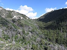
Red Box Saddle viewed from the east in 2019
Red Box is the name of the junction of the Angeles Crest Highway, the Mt. Wilson-Red Box Road, and the Rincon - Red Box Road. It is located at the 1,422 meter (4,666') saddle between and San Gabriel Peak. The saddle separates the upper Arroyo Seco drainage from the West Fork of the San Gabriel River.[1]
It was named for the red box which used to contain fire fighting tools and supplies.[citation needed] A campground and a cultural center for the Hahamongna tribe are located at the site. It is used as a drop off point to Camp Hi-Hill.
References[]
- ^ "Hike the Arroyo Second". arroyoseco.org. Retrieved July 10, 2019.

This Los Angeles County, California–related article is a stub. You can help Wikipedia by . |
Categories:
- Unincorporated communities in Los Angeles County, California
- San Gabriel Mountains
- Unincorporated communities in California
- Los Angeles County, California geography stubs