San Fernando, California
San Fernando, California | |
|---|---|
City | |
  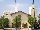 Clockwise: Santa Rosa Church; Saint Ferdinand Catholic Church; Lopez Adobe. | |
 Seal | |
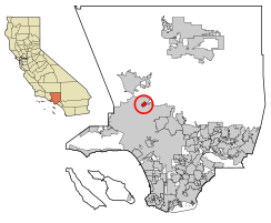 Location of San Fernando in Los Angeles County, California | |
 San Fernando Location in the United States | |
| Coordinates: 34°17′14″N 118°26′20″W / 34.28722°N 118.43889°WCoordinates: 34°17′14″N 118°26′20″W / 34.28722°N 118.43889°W | |
| Country | |
| State | |
| County | |
| Incorporated | August 31, 1911[1] |
| Named for | St. Ferdinand |
| Government | |
| • City council[2] | Mayor: Sylvia Ballin Vice Mayor: Mary Mendoza Councilmembers: Hector Pacheco Robert Gonzales |
| Area | |
| • Total | 2.37 sq mi (6.15 km2) |
| • Land | 2.37 sq mi (6.15 km2) |
| • Water | 0.00 sq mi (0.00 km2) 0% |
| Elevation | 1,070 ft (326 m) |
| Population (2010) | |
| • Total | 23,645 |
| • Estimate (2019)[7] | 24,322 |
| • Density | 10,245.16/sq mi (3,955.63/km2) |
| Time zone | UTC-8 (PST) |
| • Summer (DST) | UTC-7 (PDT) |
| ZIP Code | 91340-91342, 91344-91346[5] |
| Area code(s) | 818, 747[6] |
| FIPS code | 06-66140 |
| GNIS feature IDs | 1652786, 2411785 |
| Website | www |

San Fernando is a city in the San Fernando Valley region of Los Angeles County, California, in the Los Angeles metropolitan area. It is bordered on all sides by the City of Los Angeles. As of the 2010 census the population of San Fernando was 23,645.[8]
History[]

The city was named for the nearby Mission San Fernando Rey de España (which in turn was named after St. Ferdinand), and was part of the Mexican land grant of Rancho Ex-Mission San Fernando. In 1874 Charles Maclay, San Fernando founder, bought 56,000 acres (227 km2) of the Rancho. In 1882, cousins George K. Porter and Benjamin F. Porter of future Porter Ranch each received one-third of the total land. In 1885, Maclay founded the Maclay School of Theology, a Methodist seminary in his newly founded town of San Fernando.[9] After his death it became an affiliate and moved to the campus of the University of Southern California and then the Claremont School of Theology.
While most of the towns in the surrounding San Fernando Valley agreed to annexation by Los Angeles in the 1910s, eager to tap the bountiful water supply provided by the newly opened Los Angeles Aqueduct, San Fernando's abundant groundwater supplies allowed it to remain a separate city. In the first half of the 20th century after incorporation in 1911, the city of San Fernando has tried to annex their city limits to Sylmar, Mission Hills and Pacoima, but the city of Los Angeles has kept up their rapid annexation and caused many failed attempts; and by the 1950s, the city said that annexation was hard to do, due to the large bureaucracy of Los Angeles. As the San Fernando Valley has transitioned from an agricultural area to a suburban one in the decades after World War II, San Fernando retained its independence.
As with much of the San Fernando Valley east of the San Diego Freeway, the city of San Fernando has seen a significant demographic shift in recent years. Declining birth-rates and an aging population of middle-class whites, who once dominated the area in the 1950s, has contributed to the movement into other parts of the San Fernando Valley. There has also been movement into the Santa Clarita and Antelope Valleys to the north. Latinos became the majority population (the largest percentage in the Greater Los Angeles area at 90 percent as of 2015).[citation needed]
Geography and climate[]
This section needs additional citations for verification. (April 2014) |
San Fernando is completely surrounded by the city of Los Angeles, with the neighborhoods of Sylmar to the north, Lake View Terrace to the east, Pacoima to the south, and Mission Hills to the west. It is served by the Golden State (Interstate 5), Foothill (Interstate 210), Ronald Reagan (State Route 118), and San Diego (Interstate 405) freeways.
| hideClimate data for San Fernando, California | |||||||||||||
|---|---|---|---|---|---|---|---|---|---|---|---|---|---|
| Month | Jan | Feb | Mar | Apr | May | Jun | Jul | Aug | Sep | Oct | Nov | Dec | Year |
| Record high °F (°C) | 92 (33) |
92 (33) |
98 (37) |
103 (39) |
105 (41) |
114 (46) |
113 (45) |
112 (44) |
114 (46) |
106 (41) |
97 (36) |
90 (32) |
114 (46) |
| Average high °F (°C) | 66 (19) |
68 (20) |
70 (21) |
75 (24) |
78 (26) |
84 (29) |
92 (33) |
93 (34) |
88 (31) |
81 (27) |
72 (22) |
66 (19) |
78 (26) |
| Average low °F (°C) | 44 (7) |
45 (7) |
46 (8) |
47 (8) |
51 (11) |
55 (13) |
58 (14) |
60 (16) |
58 (14) |
53 (12) |
46 (8) |
43 (6) |
50 (10) |
| Record low °F (°C) | 23 (−5) |
26 (−3) |
28 (−2) |
30 (−1) |
32 (0) |
36 (2) |
40 (4) |
41 (5) |
39 (4) |
31 (−1) |
28 (−2) |
26 (−3) |
23 (−5) |
| Average precipitation inches (mm) | 4.14 (105) |
4.52 (115) |
3.85 (98) |
0.96 (24) |
0.25 (6.4) |
0.07 (1.8) |
0.03 (0.76) |
0.15 (3.8) |
0.34 (8.6) |
0.52 (13) |
1.48 (38) |
2.27 (58) |
18.58 (472) |
| Source: [10] | |||||||||||||
Demographics[]
| Historical population | |||
|---|---|---|---|
| Census | Pop. | %± | |
| 1920 | 3,204 | — | |
| 1930 | 7,567 | 136.2% | |
| 1940 | 9,094 | 20.2% | |
| 1950 | 12,992 | 42.9% | |
| 1960 | 16,093 | 23.9% | |
| 1970 | 16,571 | 3.0% | |
| 1980 | 17,731 | 7.0% | |
| 1990 | 22,580 | 27.3% | |
| 2000 | 23,564 | 4.4% | |
| 2010 | 23,645 | 0.3% | |
| 2019 (est.) | 24,322 | [7] | 2.9% |
| U.S. Decennial Census[11] | |||
2010[]
At the 2010 census San Fernando had a population of 23,645. The population density was 9,959.9 people per square mile (3,845.5/km2). The racial makeup of San Fernando was 12,068 (51.0%) White (5.3% Non-Hispanic White),[12] 222 (0.9%) African American, 314 (1.3%) Native American, 248 (1.0%) Asian, 33 (0.1%) Pacific Islander, 9,877 (41.8%) from other races, and 883 (3.7%) from two or more races. Hispanic or Latino of any race were 21,867 persons (92.5%).[13]
The census reported that 23,531 people (99.5% of the population) lived in households, 46 (0.2%) lived in non-institutionalized group quarters, and 68 (0.3%) were institutionalized.
There were 5,967 households, 3,247 (54.4%) had children under the age of 18 living in them, 3,282 (55.0%) were opposite-sex married couples living together, 1,098 (18.4%) had a female householder with no husband present, 592 (9.9%) had a male householder with no wife present. There were 476 (8.0%) unmarried opposite-sex partnerships, and 34 (0.6%) same-sex married couples or partnerships. 731 households (12.3%) were one person and 295 (4.9%) had someone living alone who was 65 or older. The average household size was 3.94. There were 4,972 families (83.3% of households); the average family size was 4.18.
The age distribution was 6,941 people (29.4%) under the age of 18, 2,659 people (11.2%) aged 18 to 24, 7,132 people (30.2%) aged 25 to 44, 4,920 people (20.8%) aged 45 to 64, and 1,993 people (8.4%) who were 65 or older. The median age was 30.7 years. For every 100 females, there were 100.7 males. For every 100 females age 18 and over, there were 98.2 males.
There were 6,291 housing units at an average density of 2,649.9 per square mile, of the occupied units 3,252 (54.5%) were owner-occupied and 2,715 (45.5%) were rented. The homeowner vacancy rate was 1.1%; the rental vacancy rate was 3.9%. 13,425 people (56.8% of the population) lived in owner-occupied housing units and 10,106 people (42.7%) lived in rental housing units.
According to the 2010 United States Census, San Fernando had a median household income of $55,192, with 16.9% of the population living below the federal poverty line.[14]
2000[]
At the 2000 census there were 23,564 people in 5,774 households, including 4,832 families, in the city. The population density was 9,880.7 inhabitants per square mile (3,822.7/km2). There were 5,932 housing units at an average density of 2,487.4 per square mile (962.3/km2). The racial makeup of the city was 42.76% White, 0.98% African American, 1.69% Native American, 1.12% Asian, 0.11% Pacific Islander, 49.35% from other races, and 3.98% from two or more races. Hispanic or Latino of any race were 89.28%.[15]
Of the 5,774 households 52.8% had children under the age of 18 living with them, 59.1% were married couples living together, 16.4% had a female householder with no husband present, and 16.3% were non-families. 12.4% of households were one person and 5.6% were one person aged 65 or older. The average household size was 4.07 and the average family size was 4.33.
The age distribution was 34.4% under the age of 18, 11.4% from 18 to 24, 32.1% from 25 to 44, 15.0% from 45 to 64, and 7.0% 65 or older. The median age was 27 years. For every 100 females, there were 101.7 males. For every 100 females age 18 and over, there were 99.9 males.
The median household income was $39,909 and the median family income was $40,138. Males had a median income of $26,068 versus $22,599 for females. The per capita income for the city was $11,485. 15.3% of families and 19.1% of the population were below the poverty line, including 22.5% of those under age 18 and 15.6% of those age 65 or over.
Government[]
Municipal government[]
The City of San Fernando is governed by a city council. Members of the City Council are elected and serve four year terms. The mayor is appointed every year, on a rotating basis, by a majority vote of the council. The Council meets on the first and third Monday of each month at 6:00 pm in the Council Chambers.
State and federal representation[]
In the California State Legislature, San Fernando is in the 18th Senate District, represented by Democrat Robert Hertzberg, and in the 39th Assembly District, represented by Democrat Luz Rivas.[16]
In the United States Senate, San Fernando is represented by California's Senators Dianne Feinstein and Alex Padilla.[17] In the United States House of Representatives, San Fernando is in California's 29th congressional district, represented by Democrat Tony Cárdenas.[18]
Infrastructure[]
The Los Angeles County Department of Health Services operates the Pacoima Health Center in Pacoima in Los Angeles, serving the City of San Fernando.[19]
The City of San Fernando produces, treats, sells and maintains its own water supply.[20]
The United States Postal Service operates the San Fernando Post Office.[21]
Police[]
Police services in San Fernando is provided by the San Fernando Police Department. The police department has 35 sworn police officers and 25 non-sworn personnel. The department is also augmented by 20 sworn reserve police officers. In times of need, the police department can deploy a total of 55 sworn police officers.[citation needed]
The San Fernando Police Department is a member of the Los Angeles County Disaster Management Area "C". Area "C" consists of the cities of Burbank, Pasadena, Glendale, San Fernando, San Gabriel, Monterey Park, Alhambra and South Pasadena.[22] The San Fernando Police have, in the past, requested mutual aid from the LAPD during major incidents.[citation needed]
Fire[]
The Los Angeles Fire Department provides fire protection services for the city of San Fernando, which serves the community from three nearby fire stations (Station 75, Station 91, and Station 98), all of which are located in the City of Los Angeles.[23]
Fire Station 75 in Mission Hills serves western San Fernando.[24] Fire Station 91 in Sylmar serves northeast San Fernando[25] Fire Station 98 in Pacoima serves southeast San Fernando.[26]
Transportation[]
The Sylmar/San Fernando Metrolink station serves the city on the Antelope Valley Line that passes through the city on a route adjacent to and parallel with San Fernando Boulevard. The officials and citizens have expressed their concern about the impact of the California High-Speed Rail if it follows the same route through the city.[27] The city will become the future northern terminus of the East San Fernando Valley Transit Corridor, the valley's first light rail line by 2027.[28][29]
Economy[]
Top employers[]
According to the city's 2017-2018 annual financial report,[30] the top ten employers in the city (not including the city itself as an employer) are:
| # | Employer | # of Employees |
|---|---|---|
| 1 | Los Angeles Unified School District | 2010 |
| 2 | Pharmavite LLC | 360 |
| 3 | County of Los Angeles | 277 |
| 4 | Home Depot | 271 |
| 5 | Pepsi Bottling Company | 270 |
| 6 | PureTek | 200 |
| 7 | Production Resource Group LLC | 200 |
| 8 | Vallarta Supermarkets | 162 |
| 9 | Ricon Corp | 149 |
| 10 | Valley Crest Landscape Co. | 136 |
As of 2018, the City of San Fernando has a total labor force of 11,700 with 4,035 (34.49%) working for the top ten employers listed. The City of San Fernando also employs 129 people as of 2018.[31]
Education[]

San Fernando is served by the Los Angeles Unified School District.[32]
San Fernando is served by the following LAUSD schools:
- O'Melveny Elementary School
- Morningside Elementary School
- San Fernando Elementary School
- Gridley Elementary School in nearby Sylmar[33]
- San Fernando Middle School
- San Fernando institute for Applied Media
- César Chávez Learning Academies
- San Fernando High School
- Vaughn International Studies Academy (VISA); Charter School
The nearest community college to San Fernando is Los Angeles Mission College in the Sylmar neighborhood of Los Angeles.
PUC Schools operates some charter schools in San Fernando. They include Nueva Esperanza Charter Academy (MS and HS) and PUC Inspire Charter Academy.[34][35] At one time Lakeview Charter Academy and Triumph Charter Academy, both of PUC Schools, were located in San Fernando now they are located in Sylmar.[36][37]
A private school, The Concordia Schools San Fernando, was in the city.[38] First Lutheran Schools was previously located where Concordia San Fernando was later now located.[39] In 2011 the middle and high school consolidated into Concordia Junior Senior High School.[40]
Public libraries[]
The County of Los Angeles Public Library operates the San Fernando Library at 217 North Maclay Avenue.[41]
See also[]
Notable people[]
- Paula Abdul, television personality
- Don Prudhomme, NHRA drag racing driver
- George Lopez, comedian, television actor, philanthropist
- Marlyn Mason, actress
- David Wark Griffith pioneer of silent motion pictures at his Griffith Ranch
References[]
- ^ "California Cities by Incorporation Date". California Association of Local Agency Formation Commissions. Archived from the original (Word) on November 3, 2014. Retrieved August 25, 2014.
- ^ "City Council | City of San Fernando".
- ^ "2019 U.S. Gazetteer Files". United States Census Bureau. Retrieved July 1, 2020.
- ^ "San Fernando". Geographic Names Information System. United States Geological Survey. Retrieved October 13, 2014.
- ^ "USPS - ZIP Code Lookup - Find a ZIP+ 4 Code By City Results". Retrieved 2007-01-18.
- ^ "Number Administration System - NPA and City/Town Search Results". Archived from the original on 2009-11-04. Retrieved 2007-01-18.
- ^ Jump up to: a b "Population and Housing Unit Estimates". United States Census Bureau. May 24, 2020. Retrieved May 27, 2020.
- ^ "Geographic Identifiers: 2010 Census Summary File 1 (G001), San Fernando city, California". American FactFinder. U.S. Census Bureau. Archived from the original on February 13, 2020. Retrieved September 4, 2019.
- ^ Hunt, Thomas C.; James C. Carper (1996). Religious Higher Education in the United States: A Source Book. Taylor & Francis. p. 474. ISBN 978-0-8153-1636-7. Retrieved 2009-02-01.
- ^ "Zipcode 91340". www.plantmaps.com. Retrieved April 18, 2021.
- ^ "Census of Population and Housing". Census.gov. Retrieved June 4, 2015.
- ^ [1] 'United States Census Bureau
- ^ "2010 Census Interactive Population Search: CA - San Fernando city". U.S. Census Bureau. Archived from the original on July 15, 2014. Retrieved July 12, 2014.
- ^ "Community Facts American FactFinder, United States Census Bureau". Retrieved 2014-10-14.
- ^ "U.S. Census website". United States Census Bureau. Retrieved 2008-01-31.
- ^ "Statewide Database". Regents of the University of California. Archived from the original on February 1, 2015. Retrieved February 23, 2015.
- ^ California Senators accessed November 7, 2018
- ^ "California's 29th Congressional District - Representatives & District Map". Civic Impulse, LLC.
- ^ "Pacoima Health Center." Los Angeles County Department of Health Services. Retrieved on March 17, 2010.
- ^ "San Fernando Water & Sewer." Retrieved on November 20, 2019.
- ^ "Post Office Location - SAN FERNANDO MAIN Archived 2010-03-07 at the Wayback Machine." United States Postal Service. Retrieved on March 17, 2010.
- ^ "List of Los Angeles County Operational Area Disaster Management Area Cities" (PDF). County of Los Angeles - Chief Executive Office. Retrieved 9 August 2016.
- ^ "Fire Protection Service Archived 2009-03-26 at the Wayback Machine" City of San Fernando Website Retrieved on March 16, 2009.
- ^ "Fire Station 75 Archived 2010-01-24 at the Wayback Machine." Los Angeles Fire Department. Retrieved on March 17, 2010.
- ^ "Fire Station 91 Archived 2010-03-27 at the Wayback Machine." Los Angeles Fire Department. Retrieved on March 17, 2010.
- ^ "Fire Station 98 Archived 2010-01-24 at the Wayback Machine." Los Angeles Fire Department. Retrieved on March 17, 2010.
- ^ Vartabedian, Ralph (May 30, 2015). "San Fernando leaders confront state officials over bullet train route". Los Angeles Times.
- ^ http://media.metro.net/projects_studies/east_sfv/images/map_corridor_esfv.pdf
- ^ "East San Fernando Valley Transit Corridor". www.metro.net.
- ^ http://ci.san-fernando.ca.us/wp-content/uploads/2019/01/Final-CAFR-for-print.pdf[Page 145]
- ^ http://ci.san-fernando.ca.us/wp-content/uploads/2019/01/Final-CAFR-for-print.pdf[Page 148]
- ^ https://ci.san-fernando.ca.us/wp-content/uploads/2016/02/Zoning-Map.pdf elementary and middle schools in the city limits are on this map
- ^ "Home." Gridley Elementary School. Retrieved on April 27, 2014. "1907 Eighth St. Sylmar, CA 91340"
- ^ "Nueva Esperanza Charter Academy Archived 2010-11-24 at the Wayback Machine." PUC Schools. Retrieved on November 27, 2011.
- ^ "Lakeview Charter High School Archived 2011-12-06 at the Wayback Machine." PUC Schools. Retrieved on November 27, 2011. "Lakeview Charter High School 919 Eighth Street San Fernando, CA 91340-1312"
- ^ "Triumph Charter Academy." PUC Schools. June 14, 2008. Retrieved on November 27, 2011.
- ^ "Lakeview Charter Academy." PUC Schools. June 14, 2008. Retrieved on November 27, 2011.
- ^ "Home." Concordia San Fernando. Retrieved on September 1, 2011. "777 N. Maclay, San Fernando, CA 91340"
- ^ "Home." First Lutheran Schools. Retrieved on September 1, 2011. "Elementary School: 777 N. Maclay San Fernando, CA 91340 • Phone: 818-361-4800 Jr./Sr. High School: 13361 Glenoaks Blvd., Sylmar, CA 91342"
- ^ Lin, C.J. "Valley private school options dwindling Archived 2012-08-13 at the Wayback Machine." August 17, 2011. Retrieved on August 31, 2011.
- ^ "San Fernando Library". County of Los Angeles Public Library. Accessed 8/22/2010.
External links[]
| Wikimedia Commons has media related to San Fernando, California. |
| show Places adjacent to San Fernando, California |
|---|
| show Municipalities and communities of Los Angeles County, California, United States |
|---|

| show Greater Los Angeles Area |
|---|

| show Authority control |
|---|
- San Fernando, California
- 1911 establishments in California
- Cities in Los Angeles County, California
- Communities in the San Fernando Valley
- Incorporated cities and towns in California
- Populated places established in 1911
- Enclaves in the United States