Redang Island
Native name: Pulau Redang ڤولاو رداڠ | |
|---|---|
 Pasir Panjang Beach | |
 Redang | |
| Geography | |
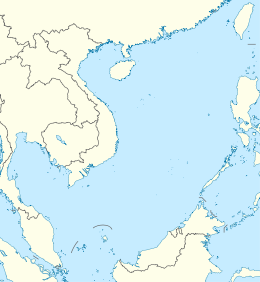
| Location | South China Sea |
| Coordinates | 5°46′30″N 103°0′54″E / 5.77500°N 103.01500°ECoordinates: 5°46′30″N 103°0′54″E / 5.77500°N 103.01500°E |
| Archipelago | Redang Archipelago |
| Total islands | 9 |
| Administration | |
Malaysia | |
| State | Terengganu |
| District | Kuala Nerus |


Redang Island (Malay: Pulau Redang) is an island in Kuala Nerus District, Terengganu, Malaysia. It is one of the largest islands off the east coast of Peninsular Malaysia. It is famous for its crystal clear waters and white sandy beaches. It is one of nine islands, which form a marine sanctuary park offering snorkeling and diving opportunities for tourists.
Archipelago[]
The Redang archipelago comprises Pulau Redang, Pulau Lima, Pulau Paku Besar, Pulau Paku Kecil, Pulau Kerengga Kecil, Pulau Kerengga Besar, Pulau Ekor Tebu, Pulau Ling and Pulau Pinang. Pulau Redang is the biggest of all the islands in the Marine Park, measuring about 7 km (4.3 mi) long and 6 km (3.7 mi) wide. Its highest peak is Bukit Besar at 359 metres (1,178 feet) above sea level. The boundary of the Pulau Redang Marine Park is established by a line linking all points 2 nautical miles (3.7 km) from the shores of Pulau Redang, Pulau Lima, Pulau Ekor Tebu and Pulau Pinang. The other nearby islands of Pulau Perhentian Besar, Pulau Perhentian Kecil, Pulau Lang Tengah, Pulau Kapas and Pulau Susu Dara are also gazetted and protected as Marine Parks. Today, only the bigger islands like Redang, Lang Tengah, Perhentian and Kapas have resort facilities for visitors. The management of Marine Parks primarily involves protection of the sensitive marine and terrestrial ecosystems by controlling the impact from human activities. These include waste pollution management and conservation of coral reefs and terrestrial habitats.
Tourism[]
In contrast to the neighbouring Perhentian Islands, Redang has a more upmarket image, as almost all accommodation on the island is resort-based. The largest beach is Pasir Panjang on the east side, featuring half a dozen resorts. The beach is covered with soft white sand. Coral and fish can be seen just a few metres from the beach. The other beach resorts are located in Teluk Dalam on the north and Teluk Kalong to the south.
The 2000 film, Summer Holiday was filmed on the Laguna Redang Island Resort, and a replica of the tea house now serves as the resort's gift shop.
The island is a turtle nesting site, and these turtles serve as a draw for ecotourism.[1]
Climate[]
Redang has a tropical climate with temperatures steadily around 30 °C (86 °F) and frequent but brief thunderstorms. Like the rest of Malaysia's east coast, Redang is affected by the northeast monsoon from the South China Sea, so most resorts are closed and ferry transport schedules are severely restricted between October and March. The amount of monthly rainfall varies throughout the year, with November to February being the wettest months, whilst April to August being the driest. The island experiences on average about 2,600 millimetres (100 in) of rain per year.
| hideClimate data for Pulau Redang | |||||||||||||
|---|---|---|---|---|---|---|---|---|---|---|---|---|---|
| Month | Jan | Feb | Mar | Apr | May | Jun | Jul | Aug | Sep | Oct | Nov | Dec | Year |
| Record high °C (°F) | 32.9 (91.2) |
34.5 (94.1) |
34.8 (94.6) |
35.5 (95.9) |
35.8 (96.4) |
35.5 (95.9) |
34.9 (94.8) |
35.5 (95.9) |
35.2 (95.4) |
34.0 (93.2) |
33.7 (92.7) |
32.3 (90.1) |
35.8 (96.4) |
| Average high °C (°F) | 29.7 (85.5) |
30.5 (86.9) |
31.5 (88.7) |
32.7 (90.9) |
33.1 (91.6) |
32.7 (90.9) |
32.3 (90.1) |
32.2 (90.0) |
31.9 (89.4) |
31.5 (88.7) |
30.0 (86.0) |
29.3 (84.7) |
31.5 (88.6) |
| Daily mean °C (°F) | 26.3 (79.3) |
26.6 (79.9) |
27.2 (81.0) |
27.9 (82.2) |
28.0 (82.4) |
27.5 (81.5) |
27.3 (81.1) |
27.0 (80.6) |
26.9 (80.4) |
26.7 (80.1) |
26.3 (79.3) |
26.2 (79.2) |
27.0 (80.6) |
| Average low °C (°F) | 23.7 (74.7) |
23.3 (73.9) |
23.7 (74.7) |
24.1 (75.4) |
24.3 (75.7) |
24.0 (75.2) |
23.7 (74.7) |
23.6 (74.5) |
23.6 (74.5) |
23.7 (74.7) |
23.7 (74.7) |
23.8 (74.8) |
23.8 (74.8) |
| Record low °C (°F) | 19.7 (67.5) |
19.4 (66.9) |
19.8 (67.6) |
22.5 (72.5) |
21.3 (70.3) |
21.2 (70.2) |
20.9 (69.6) |
21.0 (69.8) |
21.2 (70.2) |
21.2 (70.2) |
21.3 (70.3) |
20.8 (69.4) |
19.4 (66.9) |
| Average precipitation mm (inches) | 124.6 (4.91) |
73.5 (2.89) |
162.5 (6.40) |
87.0 (3.43) |
104.0 (4.09) |
116.5 (4.59) |
105.1 (4.14) |
137.5 (5.41) |
188.2 (7.41) |
224.3 (8.83) |
732.0 (28.82) |
534.8 (21.06) |
2,590 (101.98) |
| Average precipitation days | 16 | 8 | 10 | 9 | 10 | 11 | 10 | 13 | 15 | 19 | 23 | 22 | 166 |
| Average relative humidity (%) | 81 | 81 | 82 | 82 | 83 | 83 | 83 | 84 | 84 | 85 | 87 | 84 | 83 |
| Source: Malaysian Meteorological Department[2] | |||||||||||||
Transportation[]
Access is from Merang or Shahbandar jetty on boats operated by the resorts.
Features[]

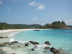 Pasir Panjang beach on Pulau Redang. |
 A rocky beach and a wooden bridge near Laguna Redang Resort in Pulau Redang. |
 White sandy beach in Pulau Redang. |
See also[]
References[]
- ^ "From egg hunter to protector, Malaysian battles to save turtles". Rappler. 21 July 2020. Retrieved 28 July 2020.
- ^ "Climate of Tourist Places in Malaysia – Pulau Redang (Redang Island)". Met Office. Archived from the original on 20 Aug 2008. Retrieved 10 May 2019.
External links[]
 Media related to Pulau Redang, Malaysia at Wikimedia Commons
| Wikivoyage has a travel guide for Redang. |
- SEATRU - A sea turtle project in Redang, Malaysia
- Tourism Malaysia - Pulau Redang
- [1]
| Authority control: National libraries |
|---|
- Islands of Terengganu
- Tourist attractions in Terengganu
- Islands of Malaysia