Reid Highway
Reid Highway | |
|---|---|
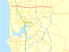 | |
Map of Perth's central suburbs with Reid Highway highlighted in red | |
 | |
| General information | |
| Type | Highway |
| Length | 23.6 km (15 mi) |
| Opened | 1980s |
| Route number(s) | |
| Major junctions | |
| West end | |
| |
| East end | |
| Location(s) | |
| Major suburbs | Balcatta, Mirrabooka, Malaga, Beechboro, Caversham |
| Highway system | |

Reid Highway is a 23-kilometre (14 mi) east-west highway and partial freeway in the northern suburbs of Perth, Western Australia, linking North Beach with Middle Swan. As part of State Route 3, it forms half of Perth's outer ring road along with Roe Highway, which it joins onto at its eastern terminus.
The highway has many different speed limits and road conditions along its length, but is predominantly a four-lane dual carriageway with a 90 km/h (56 mph) speed limit. A 12-kilometre (7 mi) section, between Erindale Road and Altone Road (which makes up just over half the highway’s length), is a continuous freeway. In conjunction with Tonkin Highway, it serves as an important arterial connection between Perth's coastal and eastern suburbs, industrial areas and Perth Airport.
History[]
Reid Highway was initially proposed in the late 1960s as the "North Perimeter Highway",[1] and a small two-lane section was built in early 1986 between Erindale Road and the-then newly extended Mitchell Freeway. In 1989 it was subsequently renamed "Reid Highway", in honour of former Western Australia Governor Gordon Reid.
The next section was built between Alexander Drive and Malaga Drive, and opened on 6 September 1991.[2] A segment linking Malaga Drive to Tonkin Highway opened later that year, on 11 November 1991,[2] with further extensions west to Mirrabooka Avenue and east to Beechboro Road opening two months later, on 11 February 1992.[2]
The highway was further extended with the section between Mirrabooka Avenue and Wanneroo Road, which opened on 17 November 1994.[2] The highway was finally made continuous on 6 September 1996 with the opening of the Erindale Road–Wanneroo Road segment.[2] A short time later, it was extended eastwards to West Swan Road. This section, which opened on 25 November 1996, provided a connection to Great Northern Highway and Roe Highway via Middle Swan Road, an existing local road.[2]
In 2001, the highway was extended west from Mitchell Freeway to Marmion Avenue as a two-lane divided carriageway, which opened on 30 July,[2] thus replacing a section of North Beach Road and making it discontinuous. This extension was highly controversial as it passes through the environmentally sensitive Carine wetlands and the Lake Carine region, which includes a vital turtle habitat. Concerns about environmental damage prompted construction delays, and slight alterations to the route.[citation needed]
Criticism[by whom?] of the quality and capacity of the highway has also been an issue. Reid Highway in Westminster (between Wanneroo Road and Mirrabooka Avenue) has no street lighting and has attracted both antisocial behaviour and a number of accidents.[citation needed] The stretch between Beechboro Road and West Swan Road has been similarly criticised,[by whom?] and the area east of the Mitchell Freeway was prone to heavy congestion due to its limited capacity as a two-lane single carriageway, before being upgraded to dual carriageway.
A four-lane dual carriageway extension of Reid Highway from West Swan Road to Great Northern Highway and Roe Highway was opened on 26 February 2010,[2][3] completing State Route 3 as a highway-grade ring road around Perth. The extension runs parallel to Middle Swan Road, which has been retained as a local access road. Middle Swan Road is of a relatively poor standard and capacity, and is viewed as a safety blackspot.
In 2011, the highway's traffic-light intersections at Alexander Drive and Mirrabooka Avenue were both upgraded to diamond interchanges, with bridges being constructed to carry highway traffic.[4][5] Along with the similarly grade-separated Wanneroo Road interchange, this completed an 8 kilometre section of grade-separated, free traffic flow between the industrial estates of Balcatta and Malaga.
The T junction at Lord Street was upgraded to a traffic light controlled intersection in 2012, with four through lanes and improved turning lanes on Reid Highway.[6] This intersection now includes Daviot Road as a southern continuation of Lord Street, which provides access to the suburb of Caversham. Lord Street has since been renamed Drumpellier Drive as a result of the New Lord Street project in 2019.
The RAC has lobbied for continued improvements to Reid Highway, calling for grade-separation at the Malaga Drive intersection, and to make the highway a dual carriageway for its entire length.[7] The WA State Government initially did not commit to further major upgrades, instead funding an upgrade to the turning lanes at the Malaga Drive intersection.[8] In December 2012, the State Government announced that the Malaga Drive intersection would be grade separated by 2014-15, with work commencing in 2013-14.[9][10][11] The project uses the same diamond interchange design that was constructed at Alexander Drive and Mirrabooka Avenue in 2011.[9] Construction started on this interchange in 2015, and was completed in 2016.
Works were completed in 2016 to upgrade the Mitchell Freeway diamond interchange to dual carriageway with a second overpass bridge, extra turning lanes, and a new looped freeway ramp.[12][13] The project aims to lower congestion, and reduce the volume of traffic using local roads to avoid the interchange.[12][13] The works also included upgrading the Duffy Road South intersection to traffic light control, and widening highway to the west of Duffy Road, as well as duplicating it from Duffy Road to Erindale Road.[9]
From early 2017 to mid-2019, works were performed as part of the NorthLink WA project to convert the intersection of Reid and Tonkin Highway to the first combination interchange in Western Australia, which also resulted in the access to Beechboro Road North removed (a flyover was built in its place) and the road duplicated to Altone Road. Tonkin Highway was extended north as the carriageway for the new Perth Darwin National Highway.[14][15] The previous Tonkin Highway intersection was unusual in that Tonkin Highway, which continues as Reid Highway west of the intersection, is the continuous section of the T junction. This allowed those following the road from the west to continue down Tonkin Highway southbound, along with Tonkin northbound continuing into Reid westbound, with those wishing to follow Reid Highway from any direction having to make a direct turn to continue either eastbound or westbound.
Reid Highway is now a dual carriageway for its entire length, with the last remaining section of single carriageway east of Mitchell Freeway, between Altone Road and West Swan Road, converted to dual carriageway in mid-2020.[16] Part of the features included a bridge connecting the northern and southern sections of Arthur Street and a second right-turning bay from Reid Highway westbound to West Swan Road northbound.

Future works[]
In December 2019, funding was assigned for developing a project for full grade separation of the last remaining signalised intersection on the section between the Mitchell Freeway and Tonkin Highway, at Erindale Road.[17]
Route description[]

Reid Highway runs between Marmion Avenue, North Beach, and Great Northern Highway, Middle Swan, where it becomes Roe Highway. West of Marmion Avenue, the highway becomes North Beach Road (west).
Beginning at an intersection with Marmion Avenue, the highway extends Eastwards to Mitchell Freeway with at-grade intersections into North Beach Road, Everingham Street, Okely Road and Duffy Road. The Mitchell Freeway interchange is a modified diamond interchange consisting of dual two-lane bridges over the freeway and railway line with two parclo cloverleaf loops serving the Reid-westbound to Mitchell-northbound traffic as well as that of the southbound entrance. The eastern half of the interchange also has connects to Balcatta Road, similar to the Great Eastern Highway/Brearley Avenue Interchange prior to the modifications made in 2018. As the interchange is built on a reservation with the capacity to be expanded into a full freeway to freeway interchange, this connection is likely to be removed when this occurs. Further on from the Mitchell/Reid Interchange, there is an at-grade intersection with Erindale Road. This intersection marks the western terminus of the freeway standard section of Reid Highway, with a diamond interchange at Wanneroo Road, which goes over Reid Highway. Conversely, the diamond interchanges at Mirrabooka Avenue, Alexander Drive and Malaga Drive all see the highway travelling over the top of the arterial roads.
The highway then enters an S-curve to reorient itself further north while also rising to pass over Tonkin Highway in the form of a combination interchange; with the Tonkin-northbound to Reid-eastbound and Tonkin-southbound to Reid-westbound movements being served by cloverleaf loops. The offset of the highway means that Reid Highway passes over the Reid-eastbound to Tonkin-southbound and Reid-westbound to Tonkin-northbound ramps prior to the main Tonkin Highway carriageway itself.
The road then passes under a bridge carrying Beechboro Road North after which the eastern terminus of the freeway standard section is reached at the signalised intersection with Altone Road. Following this are signalised intersections with Drumpellier Drive (formerly Lord Street)/Daviot Road, West Swan Road and Great Northern Highway. Between Drumpellier Drive/Daviot Road and West Swan Road is an overpass connecting Arthur Street. In between West Swan Road and Great Northern Highway there is access to Middle Swan Road through two LILO T junctions that are connected by an underpass. These LILO intersections are signposted as "temporary access". Alternative access will be required in the future, as Reid Highway is planned to be upgraded to a six lane freeway.[18] Great Northern Highway is the eastern terminus of the Highway where it continues eastwards as Roe Highway, which in turn links to Kwinana Freeway, forming a ring road around Perth.
Interchanges and intersections[]
The entire highway is located in the Perth Metropolitan Region.
| LGA | Location | km | mi | Destinations | Notes |
|---|---|---|---|---|---|
| Stirling | Carine, Karrinyup, North Beach, Watermans Bay | 0 | 0.0 | Highway terminus: continues west as North Beach Road | |
| Carine, Karrinyup | 0.3 | 0.19 | North Beach Road (east) – Carine, Karrinyup | T junction (south) | |
| Carine | 0.8 | 0.50 | Everingham Street – Carine | T junction | |
| 1.3 | 0.81 | Okely Road – Carine, Duncraig | Traffic light controlled T junction | ||
| 2.0 | 1.2 | Duffy Road (north) – Carine | T junction | ||
| 2.2 | 1.4 | Duffy Road (south) – Gwelup | Traffic light controlled T junction | ||
| Carine, Hamersley, Balcatta | 2.8– 3.2 | 1.7– 2.0 | Modified diamond interchange (Mitchell Freeway free flowing) with freeway entrance ramps looped. Traffic lights at each intersection. | ||
| Balcatta, Hamersley | 4.2 | 2.6 | |||
| Balcatta, Balga, Hamersley, Westminster | 5.5 | 3.4 | Diamond interchange | ||
| Balga, Mirrabooka, Westminster | 8.2 | 5.1 | Mirrabooka Avenue – Mirrabooka, Nollamara | Diamond interchange | |
| Bayswater, Stirling, Swan | Dianella, Mirrabooka, Malaga, Noranda | 10.4 | 6.5 | Diamond interchange | |
| Bayswater, Swan | Malaga, Noranda | 11.1 | 6.9 | Malaga Drive – Malaga, Noranda | Diamond interchange |
| Beechboro, Malaga, Noranda | 13.0 | 8.1 | Combination interchange since 2019 as part of the NorthLink WA project. Previously Reid Highway eastbound continued south as Tonkin Highway while Reid Highway westbound intersected at a traffic light controlled T Junction | ||
| Swan | Beechboro | 15.9 | 9.9 | Altone Road – Beechboro | |
| Caversham, West Swan | 18.1– 18.2 | 11.2– 11.3 | Bennett Brook Bridge | ||
| 18.8 | 11.7 | Drumpellier Drive (north) / Daviot Road (south) – Ellenbrook, Whiteman Park | Drumpellier Drive was formerly Lord Street until July 2019, completion of the New Lord Street project resulted in the name change.[19] | ||
| 20.6 | 12.8 | ||||
| 21.9– 22.1 | 13.6– 13.7 | Middle Swan Road (north) / Harris Road (south) – Caversham, Bandyup Women's Prison | Temporary access via staggered LILO T junctions | ||
| Caversham, Middle Swan, West Swan | 23.0– 23.3 | 14.3– 14.5 | Whiteman Bridge (over Swan River) | ||
| Middle Swan | 23.4 | 14.5 | Yule Avenue – Saint Mary's Church | ||
| 23.7 | 14.7 | Highway terminus: continues east as Roe Highway (National Highway 95 / State Route 3) | |||
1.000 mi = 1.609 km; 1.000 km = 0.621 mi
| |||||
Former intersections[]
 Beechboro Road North (State Route 53, formerly an intersection, now a flyover as part of NorthLink WA)
See also[]
References[]
- ^ Maunsell & Partners; Stirling (W.A. : Municipality). Council (1986), North Perimeter Highway : Mitchell Freeway to Marmion Avenue : impact study report, Maunsell & Partners, retrieved 3 October 2014
- ^ Jump up to: a b c d e f g h "Major Metropolitan Road Network Changes". Major Network Changes. Main Roads Western Australia. 20 April 2011. Archived from the original (PDF) on 2 April 2012. Retrieved 30 November 2012.
- ^ Reid Highway Extension Archived 3 July 2009 at the Wayback Machine, Main Roads Western Australia
- ^ Mirrabooka Ave overpass Archived 12 March 2011 at the Wayback Machine, Main Roads Western Australia
- ^ Reid Highway Overpass, Main Roads Western Australia
- ^ Frank, Caroline (16 May 2012). "Lights for Lord St blackspot". Community Newspaper Group. Retrieved 4 July 2012.
- ^ "State Budget Submission 2012/13". Royal Automobile Club of Western Australia. February 2012. p. 12. Archived from the original (PDF) on 12 June 2012. Retrieved 14 June 2012.
- ^ "Green light to end red-light frustration". Community Newspaper Group. 21 June 2011. Archived from the original on 28 July 2013. Retrieved 4 July 2012.
- ^ Jump up to: a b c "State Govt's $500m northern suburbs roads package". Ministerial Media Statements. Government of Western Australia. 2 December 2012. Retrieved 6 December 2012.[permanent dead link]
- ^ Mullany, Ashlee (1 December 2012). "$500 million roads fix favours northern suburbs". The Sunday Times. Retrieved 6 December 2012.
- ^ Price, Margaret (6 December 2012). "Freeway 'blow out' fears". Joondalup Weekender. Retrieved 6 December 2012.
- ^ Jump up to: a b "Upgrade for Mitchell Fwy/Reid Hwy interchange". Ministerial Media Statements. Government of Western Australia. 12 October 2012. Retrieved 28 October 2012.[permanent dead link]
- ^ Jump up to: a b Lette, Erienne (12 October 2012). "Notorious intersection to be upgraded". Stirling Times. Retrieved 29 October 2012.
- ^ "Central: Reid Highway - Ellenbrook". Main Roads Western Australia. Retrieved 4 January 2017.
- ^ "Central: Reid Hwy - Ellenbrook". project.mainroads.wa.gov.au. Retrieved 12 June 2017.
- ^ "Reid Highway Dual Carriageway". Main Roads WA. Retrieved 22 September 2019.
- ^ "Joint statement – Infrastructure to boost jobs and bust congestion". Mirage News. Retrieved 8 December 2019.
- ^ "Information Sheet 2" (PDF). Reid Highway Extension. Main Roads Western Australia. November 2007. Retrieved 26 June 2012.
- ^ "New Lord Street" (PDF). Main Roads WA. Archived from the original (PDF) on 24 August 2019. Retrieved 24 August 2019.
- Notes
- MSN Maps and Directions
- Skyview WA - Department of Land Information Western Australia
- UBD and Metropolitan Street Directories - Various Editions, 1970s-1990s.
| show Road infrastructure in Western Australia |
|---|
Route map:

| ( • help)
|
| Wikimedia Commons has media related to Reid Highway. |
- 1980s establishments in Australia
- Highways and freeways in Perth, Western Australia