Renswoude
Renswoude | |
|---|---|
Municipality | |
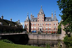 Renswoude Castle | |
 Flag  Coat of arms | |
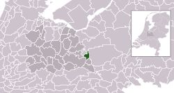 Location in Utrecht | |
| Coordinates: 52°4′N 5°33′E / 52.067°N 5.550°ECoordinates: 52°4′N 5°33′E / 52.067°N 5.550°E | |
| Country | Netherlands |
| Province | Utrecht |
| Government | |
| • Body | Municipal council |
| • Mayor | (CDA) |
| Area | |
| • Total | 18.51 km2 (7.15 sq mi) |
| • Land | 18.40 km2 (7.10 sq mi) |
| • Water | 0.11 km2 (0.04 sq mi) |
| Elevation | 8 m (26 ft) |
| Population (January 2019)[4] | |
| • Total | 5,259 |
| • Density | 286/km2 (740/sq mi) |
| Time zone | UTC+1 (CET) |
| • Summer (DST) | UTC+2 (CEST) |
| Postcode | 3927 |
| Area code | 0318 |
| Website | www |

Renswoude (Dutch pronunciation: [rɛnsˈʋʌudə] (![]() listen)) is a municipality and a town in the central Netherlands, in the province of Utrecht.
listen)) is a municipality and a town in the central Netherlands, in the province of Utrecht.
Topography[]

Dutch Topographic map of the municipality of Renswoude, June 2015
Notable people[]
- Jan Hendrik Waszink (1908–1990) a Dutch Latin scholar and academic
- Roel Robbertsen (born 1948) a Dutch politician and pig farmer
- Henk-Jan Held (born 1967) a volleyball player, team silver medallist at the 1992 Summer Olympics and team gold medallist at the 1996 Summer Olympics
- Maarten Van Garderen (born 1990) a Dutch male volleyball player, member of the Netherlands men's national volleyball team
Gallery[]

Church designed by Jacob van Campen for the grandfather of Maria Duyst van Voorhout's husband
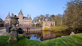
Renswoude Castle

Gemeentehuis, Renswoude


References[]
- ^ "college van B&W" [Board of mayor and aldermen] (in Dutch). Gemeente Renswoude. Archived from the original on 9 April 2014. Retrieved 8 April 2014.
- ^ "Kerncijfers wijken en buurten 2020" [Key figures for neighbourhoods 2020]. StatLine (in Dutch). CBS. 24 July 2020. Retrieved 19 September 2020.
- ^ "Postcodetool for 3927BD". Actueel Hoogtebestand Nederland (in Dutch). Het Waterschapshuis. Retrieved 8 April 2014.
- ^ "Bevolkingsontwikkeling; regio per maand" [Population growth; regions per month]. CBS Statline (in Dutch). CBS. 1 January 2019. Retrieved 1 January 2019.
External links[]
 Media related to Renswoude at Wikimedia Commons
- Official website
| show Places adjacent to Renswoude |
|---|

| show Authority control |
|---|
This Utrecht location article is a stub. You can help Wikipedia by . |
Categories:
- Renswoude
- Municipalities of Utrecht (province)
- Populated places in Utrecht (province)
- Utrecht (province) geography stubs