Reo Purgyil
| Reo Purgyil | |
|---|---|
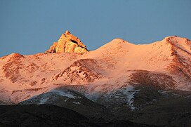 View of the peak | |
| Highest point | |
| Elevation | 6,816 m (22,362 ft) |
| Prominence | 1,978 m (6,490 ft)[1] |
| Listing | List of Indian states and territories by highest point List of Ultras of the Himalayas |
| Coordinates | 31°53′02″N 78°43′53″E / 31.8840°N 78.7314°ECoordinates: 31°53′02″N 78°43′53″E / 31.8840°N 78.7314°E[2] |
| Geography | |
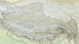
 Reo Purgyil Location of Reo Purgyil peak in Himachal Pradesh | |
| Location | Pooh tehsil, Kinnaur district, Himachal Pradesh, India Zanda County, Ngari Prefecture, Tibet Autonomous Region, China |
| Parent range | Western Himalaya |
| Climbing | |
| First ascent | 1971 |
| Easiest route | Climb |

Reo Purgyil, sometimes known as Leo Pargial[3] and Leo Pargil,[4] is a mountain peak at the southern end of the Zanskar Range in the Western Himalaya. It is located the border between Himachal Pradesh, India and Tibet.[5]
At 6,816 m, Reo Purgyil is the highest mountain peak in the state of Himachal Pradesh and is located in Kinnaur district. Geologically the peak is a dome structure and is part of a great massif that rises above the Sutlej river and overlooks the western valleys of Tibet.[2] The Spiti River, a right hand tributary of the Satluj, drains the northern face of the massif.[6]
The highest peak is often obscured by clouds and is located about 2 km to the south of Peak 6791, a well known slightly shorter twin with a height of 6,791 m.[7] Peak 6791 is widely referred to as Leo Pargial and has sufficient topographic prominence to be classified as a mountain in its own right.[8][9] Nako village is located on the slopes of the mountain, close to the India-Tibet border.
Climbing history[]
- 1st official ascent (1971) by ITBP (Indo Tibetan Border Police)[7]
- 2nd ascent (1991) by E. Theophilus and team[7]
- 2018 ascent by Rajsekhar Maity and a Bengali team [10]
See also[]
- Geography of Himachal Pradesh
- List of peaks in Himachal Pradesh
- List of mountains in India
- List of mountains by elevation
References[]
- ^ "Reo Pargial, China/India". Peakbagger.com. Retrieved 11 November 2015.[self-published source?]
- ^ a b "Reo Purgyil, 6816 m". wikimapia. Retrieved 11 November 2015.
- ^ Leo Pargial – Climbing, Hiking & Mountaineering
- ^ [dead link]Leo Pargil dome
- ^ "Tibet Ultra-Prominences". peaklist.org. Retrieved 11 November 2015.
- ^ Ciliberto, Jonathan (2013). Six Weeks in the Spiti Valley. Atlanta: Circle B Press. ISBN 978-0-9659336-6-7.
- ^ a b c [dead link]"Reo Purgyil; Beneath the shroud". The Himalayan Journal. 1992. Retrieved 11 November 2015.
- ^ Kapadia, Harish (1999). Across Peaks & Passes in Himachal Pradesh. Atlanta: Indus Publishing. ISBN 978-8-1738709-9-6.
- ^ "High Asia - All mountains and main peaks above 6650 m". Retrieved 27 February 2017.
- ^ "Bengali team braves adverse conditions to reach the peaks of Reo Purgyil". dreamwanderlust.com. 11 August 2018.
External links[]
- Khab, Kinnour, Himachal Pradesh, India
- Dome formation and extension in the Tethyan Himalaya, Leo Pargil, northwest India - University of California, Santa Barbara
| Topics | |||||||
|---|---|---|---|---|---|---|---|
| History |
| ||||||
| Culture | |||||||
| Jurisdiction | |||||||
| Districts and divisions |
| ||||||
| Major cities | |||||||
| Economy | |||||||
| Geography |
| ||||||
| Images and Others | |||||||
- Himalayas
- Highest points of Indian states and union territories
- Mountains of Himachal Pradesh
- Geography of Kinnaur district
- Six-thousanders of the Himalayas