Sirmaur district
This article may require copy editing for grammar, style, cohesion, tone, or spelling. (August 2021) |
This article needs additional citations for verification. (November 2016) |
Sirmaur district | |
|---|---|
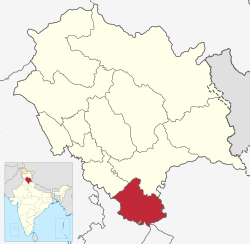 Location of Sirmaur district in Himachal Pradesh | |
| Coordinates (Nahan): 30°38′N 77°26′E / 30.64°N 77.44°ECoordinates: 30°38′N 77°26′E / 30.64°N 77.44°E | |
| Country | |
| State | |
| Headquarters | Nahan |
| Tehsils | 7 |
| Government | |
| • Vidhan Sabha constituencies | 5 |
| Area | |
| • Total | 2,825 km2 (1,091 sq mi) |
| Population (2011) | |
| • Total | 529,855 |
| • Density | 190/km2 (490/sq mi) |
| Demographics | |
| • Literacy | 79.98% |
| • Sex ratio | 915 |
| Time zone | UTC+05:30 (IST) |
| Website | http://hpsirmaur.nic.in/ |
Sirmaur is the southernmost district of Himachal Pradesh, northern India. It is largely mountainous and rural, with 90% of its population living in villages. Some of its towns include Nahan (the capital), Paonta Sahib and Suketi, the latter known for the Shivalik Fossil Park.
Geography[]
There are seven tehsils in this district, namely Nahan, Renuka, Dadahu, Shillai, Rajgarh, Pachhad and Paonta Sahib. The divides the district into two almost equal parts: Giripar and Giriaar. The major towns are Nahan, Paonta Sahib, Rajgarh and Shillai.
Demographics[]
According to the 2011 census Sirmaur district has a population of 529,855.[2] This gives it a ranking of 542nd in India (out of a total of 640).[3] The district has a population density of 188 inhabitants per square kilometre (490/sq mi) .[3] Its population growth rate over the decade 2001-2011 was 15.61%.[3] Sirmaur has a sex ratio of 915 females for every 1000 males,[3] and a literacy rate of 79.98%.[3]
At the 2011 census, 39% of the population of the district identified their first language as Hindi, 34% – as Pahari, and 20% – as Sirmauri. There were also speakers of Punjabi (3.9%), Nepali (0.94%), Haryanvi, (0.43%), Tibetan (0.42%) and others.[4]
Culture[]
A majority of the population is Hindu and hence most people worship Hindu deities (devtas) and observe various related customs and rituals.[citation needed] The local language is Sirmauri.
Bishu is a fair that is held at several locations, and features the Thoda dance. Nati, Gee, Rasa and Budhechu are styles of folk dance in Sirmaur. These are enjoyed at special occasions such as weddings and the Diwali festival.
History[]
| Year | Pop. | ±% p.a. |
|---|---|---|
| 1901 | 135,667 | — |
| 1911 | 138,500 | +0.21% |
| 1921 | 140,428 | +0.14% |
| 1931 | 148,547 | +0.56% |
| 1941 | 156,003 | +0.49% |
| 1951 | 166,053 | +0.63% |
| 1961 | 197,488 | +1.75% |
| 1971 | 244,922 | +2.18% |
| 1981 | 306,897 | +2.28% |
| 1991 | 379,695 | +2.15% |
| 2001 | 458,593 | +1.91% |
| 2011 | 529,855 | +1.45% |
| source:[5] | ||
Sirmaur was an independent kingdom in India, founded in about 1090 by Raja Rasaloo of Jaisalmer, one of whose ancestors was named Sirmaur. It became an 11 Gun Salute princely state in British India,The premier ruler of the Punjab Hills, located in the region that is now the Sirmaur district of Himachal Pradesh. The state was also known as Nahan, after its main city, Nahan. Sirmaur was ruled by the chiefs of sirmour Rajput lineage, who used the title "Maharaja".
Economy[]
The district's economy is based mainly on agriculture, including potatoes, ginger, tomatoes, apples, mangoes and peaches in the Rajgarh region, known locally as "the Peach Bowl". At Dhaula Kuan near Paonta Sahib there is a government-operated fruit research center. At the village Lana-cheta, farmers grow mainly grain.
In recent years[when?] there has been growth in various light industries including pharmaceuticals and manufacturing in Paonta Sahib. This has been mainly because of the town's location and proximity to other state borders. The state government has also provided subsidies on taxes to entrepreneurs and industrialists to set up their operations in the town.
The district has mineral resources. Kamrau is a small village known locally as the "place of limestone millionaires". Sataun is the largest limestone market of South East Asia.
Places of interest[]
There are many small towns and scenic places in Sirmaur District.
Habban Valley[]
Habben Valley's best-known temples are Shirgul Devta, Palu Devta and Tokro Tibba Kali Maa. At Habben there are two well-known temples, Tokro Tibba Kali Maa and Palu Devta. Habbi 1500, a well-known Rajpoot caste, belongs to these two Devtas. Lord Shirgul Temple is one of the most famous temples in North India.[citation needed] Lord Shirgul is worshipped in Sirmaur, Solan, Shimla, Uttaranchal, and Delhi. Thick Deodar forests are visited by tourists from many parts of India. A trek leads to Churdhar, the Holy place of Lord Shiva.
Churdhar[]

The Chur Peak in district Sirmmaur rises to an elevation of 3647 m above sea level. The mountain is an important religious place for all Sirmauries. It is one of the Shivalik ranges at a height of 11965 feet, and is the highest peak in southern Himachal Pradesh. Churdhar, also known as Churchandni (Bangle of Snow), is known for its landscapes. The view from the summit offers a panorama of lowland tracts towards the south and snow-capped ranges, including the peaks of Badrinath and Kedarnath in the Garhwal region, towards the north. It is believed that this is the very place where Hanuman discovered the life-restoring Sanjivini booti, which revived Lakshmana, Lord Rama’s younger brother. Ruins of an ancient town have been discovered at the nearby dundi Devi.
Herbs and alpine flora cover these Himalayan slopes, and fauna include the monal, Himachal’s state bird, along with koklass and kaleej pheasants.
Trekkers tread over small glaciers on their way to Churdhar summit, which has moderate to heavy snowfall (average of 33 feet snow). Often the Shirgul temple gets buried under it. On clear sunny days, the Badrinath and Kedarnath shrines, Gangetic plains, the Sutlej river and hills of Shimla and Chakrata can be seen. Atop the Churdhar summit there are lingams of Shiva and Kali, where goat and sheep were formerly sacrificed. Devotees hoist flags and make offerings here.
The peak can be approached from Dadahu, headquarter of Renuka tehsil, via Sangrah, Bhawai, Gandhuri and Naura, at a distance of about 48 kilometres (30 mi) by bridle path. Another approach to the peak is by the Solan Rajgarh Menus road.
Renuka Ji[]
Renuka is another place of religious and tourist interest in Sirmaur. It is nearly 40 kilometres (25 mi) from Nahan via a motorable metalled road. Boating is not available for visitors at Renuka Lake, an oval-shaped lake with a circumference of 2.4 kilometres (1.5 mi). The lake is visited by thousands of pilgrims every year on Kartiki Ekadashi. There is a 1.6 kilometres (0.99 mi) patch between the Giri and humming camp where visitors often stay for a couple of days. Nightlong festivities including Kirtans are held by various groups.
The place reaches full capacity during the days of the fair and offers a variety of activities. At the entrance to the fairground there is a notice board put up by the Wild Life Wing of the Forest Department warning, "Hold Your Gun--Game Sanctuary Starts".
To this fair, the brass idol of Parasu Rama is brought from the village Jamu, his permanent abode, in a silver palki accompanied by musical instruments. The deity remains in the temple for three days i.e. sudi, dashmi to dwadashi (from 10th to 12th of the bright half). The hill people pray to pujari with questions during the night when he goes into a trance and turns into an oracle, answering questions and sometimes asking of the questioner some offering or sacrifice to the deity of some other act as a condition precedent to the fulfillment of the favourable prophecy, such as deliverance from a problem or recovery of health from some disease.[citation needed] On Dwadashi, generally, the people offer alms after the holy dip in the Renuka.[citation needed]
Chanpur Dhar[]
Chanpur Dhar is another place that is undiscovered by trekkers and tourists.[citation needed] Although the locals have been visiting the temple dedicated to from time to time the place still lacks the attention of the government.[original research?] It is almost an 8 kilometers trek from bus stop and takes a maximum of 4 hours to reach the top of the Shirgul Devta temple.[citation needed]
Haripur Dhar[]
This place is at an elevation of 2687 m. Maa Bhangayani Temple, Haripurdhar, is a well-known temple in Sirmaur. Haripur is the name applied to a mountain called Haripur Dhar. A fort on a peak of this hillwas built on this range of mountain by the rulers of erstwhile Sirmur State. It was primarily meant to guard the state frontiers with the neighbouring Jubbal State as there were constant boundary disputes between the two states and there was an unusual encroachment into each other's territory. It has fallen into disuse and the part which is still habitable is used by the Forest Department as forester’s headquarters. The fort reminds the visitor of the historical period when to hold or capture such forts used to be the chief aim of the contending hill states. At a distance of about 106 kilometres (66 mi) from Nahan, Haripurdhar can be approached by a regular bus service covering 40 kilometres (25 mi) up to Dadahu, wherefrom Andheri can be reached by jeep for about 44 kilometres (27 mi). The remaining portion is about 22 kilometres (14 mi). Another way to approach is from Solan via Rajgarh. Kharotiyon, a place from where the site of the fort remains about 2 kilometres (1.2 mi) on the hilltop.
Bhureshwar Mahadev[]
Bhureshwar Mahadev is another religious and tourist destination in Sirmaur district. It is situated on a peak nearer to Sarahan on the Nahan - Solan state highway. There is a legend about this place that from here Mata Parvati and Lord Shiva saw the Kurukshetra War, as described in the Mahabharata. From here Chandigarh can also be seen.
Shillai[]
Shillai Subdivision of Sirmaur District p, which includes the area from Sataun to Haripur Dhar is a tourist destination for people from India and abroad, especially in the summer season. NH-707 (old NH-72) is the national highway as from Paonta Sahib to Hatkoti. There are many places where tourists come to enjoy nature:- Shillai, Kandi Sundrari, Mashwa waterfall, Shikando,Bohal, Digwah, Devthal, Chanpurdhar, Suinal.[citation needed] Most tourists come in the month of winter seasons.[citation needed]
See also[]
Notable people[]
- Yashwant Singh Parmar, the first CM of Himachal Pradesh
- Mohit Chauhan, singer, is from Nahan town
- Rahul Verma Rajput, National level cricketer, Mister India debutant 2018, model, is from District Sirmaur
- Siddharth Chauhan, independent filmmaker, was born in Renuka
- "The Great Khali" (Dalip Singh Rana), WWE wrestler, is from Dhiraina, Himachal Pradesh
- Rakesh Pandey, actor, is from Nahan
References[]
- ^ "Sirmaur district Population". Census India. Retrieved 11 July 2021.
- ^ http://www.censusindia.gov.in/2011census/dchb/0210_PART_B_DCHB_SIRMAUR.pdf p. 26.
- ^ a b c d e "District Census 2011". Census2011.co.in. 2011. Retrieved 30 September 2011.
- ^ C-16 Population By Mother Tongue – Himachal Pradesh (Report). Office of the Registrar General & Census Commissioner, India. Retrieved 6 October 2019.
- ^ Decadal Variation In Population Since 1901
External links[]
- Official website
- DISTRICT PROFILE
- CULTURAL & TOURISM HERITAGE OF THE DISTRICT
- Sirmour at a glance
- History of Sirmour
- Information about Sirmour District and its various places
Places adjacent to Sirmaur district | |
|---|---|
| Topics | |||||||
|---|---|---|---|---|---|---|---|
| History |
| ||||||
| Culture | |||||||
| Jurisdiction | |||||||
| Districts and divisions |
| ||||||
| Major cities | |||||||
| Economy | |||||||
| Geography |
| ||||||
| Images and Others | |||||||
| Lakes |  | |
|---|---|---|
| Rivers | ||
| Districts | ||
| Other |
| |
Authority control | |
|---|---|
| General | |
| National libraries | |
- Sirmaur district
- History of Himachal Pradesh
- Districts of Himachal Pradesh