Una district
This article possibly contains original research. (July 2021) |
This article needs additional citations for verification. (November 2019) |
Una district | |
|---|---|
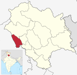 Location of Una district in Himachal Pradesh | |
| Coordinates (Una, Himachal Pradesh, India): 31°28′34″N 76°16′13″E / 31.47611°N 76.27028°ECoordinates: 31°28′34″N 76°16′13″E / 31.47611°N 76.27028°E | |
| Country | |
| State | |
| Established | 1 September 1972 |
| Headquarters | Una |
| Tehsils | 5 |
| Government | |
| • Parliamentary Constituency | Hamirpur |
| • Member of Parliament | Anurag Singh Thakur |
| • Legislative Assembly | Una |
| Area | |
| • Total | 1,540 km2 (590 sq mi) |
| Population (2011) | |
| • Total | 521,173 |
| • Density | 340/km2 (880/sq mi) |
| • Urban | 8.8% |
| Demographics | |
| • Literacy | 87.23% |
| • Sex ratio | 977 |
| Time zone | UTC+05:30 (IST) |
| Vehicle registration | HP-72 (District RTO) |
| Average annual precipitation | 1253 mm |
| Website | http://hpuna.nic.in/ |

Una is a district in the Indian state of Himachal Pradesh. Una shares its border with the Hoshiarpur and Rupnagar districts of Punjab and Kangra, Hamirpur and Bilaspur district of Himachal Pradesh. The terrain is generally semi-hilly with low hills.
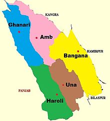
Una has five tehsils, namely Ghanari, Haroli, Amb, Bangana and Una itself. It was a tehsil of Hoshiarpur district until the Punjab Reorganisation Act, 1966 and Kangra district until 1972, after which it became a district of Himachal Pradesh.
Geography[]
Una lies in the south-western part of Himachal Pradesh, with the Sivalik Hills of the Himalayas rolling on one side. The Satluj river passes alongside Shahtalai Hills, known for the shrine of Baba Balak Nath.
The altitudes vary from more than 408 meters in city Una to over 1000 meters in Chintpurni. Una district is bounded by the river Beas on the north and the river Satluj in the east, the Swan River which is basically seasonal river flows 65 km right across the Jaswan Valley towards south until it submerges in the Sutlej river near Anandpur.[1]
Demographics[]
| Year | Pop. | ±% p.a. |
|---|---|---|
| 1901 | 165,000 | — |
| 1911 | 161,786 | −0.20% |
| 1921 | 161,856 | +0.00% |
| 1931 | 170,620 | +0.53% |
| 1941 | 194,249 | +1.31% |
| 1951 | 196,829 | +0.13% |
| 1961 | 226,696 | +1.42% |
| 1971 | 261,357 | +1.43% |
| 1981 | 317,422 | +1.96% |
| 1991 | 378,269 | +1.77% |
| 2001 | 448,273 | +1.71% |
| 2011 | 521,173 | +1.52% |
| source:[3] | ||
According to the 2011 census Una district has a population of 521,173,[4] giving it a ranking of 543rd in India (out of a total of 640).[4] The district has a population density of 338 inhabitants per square kilometre (880/sq mi).[4] Its population growth rate over the decade 2001-2011 was 16.24%.[4] Una has a sex ratio of 977 females for every 1000 males,[4] and a literacy rate of 87.23%.[4]
Local languages are Himachali, Hindi and Punjabi. Punjabi with mixture of Himachali language is mostly used in plain areas of Una City, tehsil Ghanari and Haroli Tehsil. But in other areas like Bangana, Amb and Chintpurni Himachali language is widely spoken.
According to the 2001 census, the total population of Una was 447,967 with a sex-ratio of 997. The literacy rate stood at 81.09%. In 2011, population figures were raised to 521,057 with decreased sex ratio of 977. The literacy rate increased to 87.23%. The total area of the district is 1,549 km2 (598 sq mi). The urban population contributes nearly 9% of the total population. Hinduism is the most common religion. Sikhism and Islam have sizable number of followers. Christians and others form very small minorities.
Education[]
Schools[]
Vashist public school
Temples[]
Chintpurni is the most visited temple by Hindus and Sikhs, especially on weekends and on special religious days. The Hindu genealogy registers are kept at Chintpurni too.
Mahakaal Mahakaali Temple is a temple situated in Rakkar Colony, Una dedicated to the Goddess Mahakali & Lord of Lords Mahakaal.[5]
Transport[]
Road[]
Una is connected by road and only one railway line through The NH-503 national highway passes through the city. Una is located about 375 km (233 mi) north of New Delhi and 120 km (75 mi) from Chandigarh.
Railways[]
The Una city is served by the Una Himachal railway station. It is connected by a single broad gauge railway line, which is the only one in the whole state. It enters Una from Nangal (Punjab) and runs all the way to Daulatpur. Two express trains (Himachal Express and Jan Shatabdi Express) connect it to Delhi daily.
Air[]
The nearest domestic airport is based in Chandigarh, and an airport with international operations is in Amritsar.
Places near Una[]
External links[]
References[]
- ^ "Swan River". Archived from the original on 1 October 2012.
- ^ "Una district Population". Census India. Retrieved 11 July 2021.
- ^ Decadal Variation In Population Since 1901
- ^ a b c d e f "District Census 2011". Census2011.co.in. 2011. Retrieved 30 September 2011.
- ^ "Mahakaal Mahakali Temple". Punjab Kesari.
Places adjacent to Una district | |
|---|---|
| Topics | |||||||
|---|---|---|---|---|---|---|---|
| History |
| ||||||
| Culture | |||||||
| Jurisdiction | |||||||
| Districts and divisions |
| ||||||
| Major cities | |||||||
| Economy | |||||||
| Geography |
| ||||||
| Images and Others | |||||||
| Lakes |  | |
|---|---|---|
| Rivers | ||
| Districts | ||
| Other |
| |
- Una district
- Districts of Himachal Pradesh