River Dart
| River Dart | |
|---|---|
 | |
| Location | |
| Country | England |
| County | Devon |
| Physical characteristics | |
| Source | West Dart |
| • location | Lower White Tor |
| • elevation | 450 m (1,480 ft) |
| 2nd source | East Dart |
| • location | Kit Rock, Whinney's Down |
| • elevation | 510 m (1,670 ft) |
| Source confluence | |
| • location | Dartmeet |
| • elevation | 210 m (690 ft) |
| Mouth | English Channel |
• coordinates | 50°20′33″N 3°33′51″W / 50.34250°N 3.56417°WCoordinates: 50°20′33″N 3°33′51″W / 50.34250°N 3.56417°W |
• elevation | 0 m (0 ft) |
| Length | 75 km |
| Discharge | |
| • location | Austins Bridge, Buckfastleigh |
| • average | 11.04 m3/s (390 cu ft/s) |
| • maximum | 40 m3/s (1,400 cu ft/s) |

The River Dart is a river in Devon, England, that rises high on Dartmoor and flows for 75 kilometres (47 mi) to the sea at Dartmouth.[1]
Name[]
Most hydronyms in England derive from the Brythonic language (from which Cornish developed) and the river's subsequent names ultimately derive from an original Celtic etymology. As the lower stretches of the river are still covered in ancient oak woodlands, it is accepted that the first element derives from *Dar-, meaning oak (Cornish derow, Welsh derw).[2] However the second element (evident in the hard consonantal termination of Dar-t) is less certain, with postulated etymologies from Darwent / Derventio (Sacred place of Oak) or Darnant / Darant (Oak stream).
The Ravenna Cosmography records a number of Latinised names for the area, Devionisso Statio and Deventiasteno may represent corrupted doublets of a Statio (Station) on a river named Derventio.[3] Although the name Derventio is otherwise unattested for the river, it is an established etymology throughout Britain, found at Derwentwater, and a number of rivers named Derwent.[4] Anna Eliza Bray recorded that a version of the name, Darant was still in common usage as late as 1832.[5]
Watercourse[]
The river begins as two separate branches (the East Dart and West Dart), which join at Dartmeet. The paths along these rivers offer very attractive walking, and there are several small waterfalls. The rivers are crossed by a number of clapper bridges, notably at the hamlet of Postbridge.
After leaving the moor, the Dart flows southwards past Buckfast Abbey and through the towns of Buckfastleigh, Dartington and Totnes. At Totnes, where there is a seventeenth-century weir (rebuilt in the 1960s),[6] it becomes tidal, and there are no bridges below the town.

A passenger ferry operates across the river from the village of Dittisham to a point adjacent to the Greenway Estate. Formerly the home of the late crime writer Agatha Christie, this has stunning views across the river, and the house and gardens are now owned by the National Trust and are open to the public.[7]
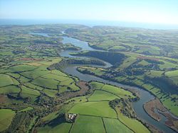
The Dart estuary is a large ria and is popular for sailing. The village of Kingswear and town of Dartmouth are on the east and west sides of the estuary, and are linked by two vehicle ferries and a passenger ferry. The Kingswear Regatta is held each year. The deep water port of Dartmouth is a sheltered haven.
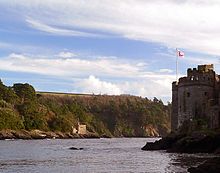
The entrance to the river from the sea is a rocky entrance with cliffs either side. On the East side Kingswear Castle sits very close to the water's edge, and on the west side Dartmouth Castle is built on a rocky promontory at sea level. The castles once operated a defensive chain across the estuary, which was raised at dusk to destroy enemy ships attempting to attack the harbour. The remains of the operating mechanisms for the chain are still visible in Dartmouth castle.
Crossings[]

The flooded ria that forms the lower reaches of the Dart, with its deep water and steeply sloping valley sides, is a considerable barrier to crossing traffic. There are no bridges below Totnes.
At the mouth of the river, it separates the communities of Dartmouth and Kingswear. There have been proposals to bridge the river here, but these have come to nothing. Instead the two places are linked by, in order going upstream, the Lower Ferry, Passenger Ferry and Higher Ferry. The Lower and Higher ferries both carry vehicles, the Higher one linking the A379 road.
Some 2.5 miles (4.0 km) upstream of Dartmouth, the carries pedestrians across the river from the village of Dittisham to Greenway Quay.[7]
A further 5 miles (8.0 km) upstream is Totnes, where the river is spanned by two road bridges, a railway bridge and a footbridge over. Totnes Bridge is the nearest bridge to the sea and is a road bridge built in 1826–1828 by Charles Fowler. Some 1,000 feet (300 m) upstream is Brutus Bridge, constructed in 1982 as part of a road traffic-relief scheme and carrying the concurrent A385 and A381 roads. A further 0.5 miles (0.80 km) upstream, the railway bridge carries the National Rail Exeter to Plymouth line over the river. Immediately upstream of the railway bridge is a footbridge, built in 1993 to provide access to the Totnes (Riverside) terminus of the South Devon Railway.[8][9][10]
[]

The lower section of the River Dart forms Dartmouth Harbour, a deep water natural harbour with a long history of maritime usage. In modern times, the port's commercial activity has declined, but it is still a busy port for local fishing vessels and a wide variety of yachts and other private boats. Several local companies specialise in shipbuilding and repairs to small tonnage craft.[11]
Dartmouth is also the home of the Britannia Royal Naval College and as a result is routinely visited by sizeable naval ships. Smaller naval tenders are often seen carrying out training exercises in the harbour and river. Large cruise ships are occasional visitors, with the largest visitor to date being the MV Royal Princess (30,277 GT).[11][12]
Upstream, the Dart is navigable to seagoing vessels as far as the weir in Totnes. The river almost dries out for 2 miles (3.2 km) below Totnes at spring tide low water, but vessels drawing up to 3 foot (0.91 m) can proceed to Totnes from one and a half hours after low water. Above the weir, the river is navigable only to small craft such as kayaks and canoes.[13]
Several companies operate trips on the river, including Dart Pleasure Craft Limited, who also trade as River Link and operate the passenger ferry between Dartmouth and Kingswear. These include cruises from Dartmouth to Totnes, which can be combined with journeys on the Paignton and Dartmouth Steam Railway and an open top bus between Totnes and Paignton to create a circular trip.[14]
The harbour and port are popular leisure boating locations, and several marinas and boat yards are located on the river. The Port of Dartmouth Royal Regatta takes place annually over three days at the end of August.
Canoeing and kayaking[]

The upper reaches of Dartmoor, especially those on the Dart, are a focal point for whitewater kayakers and canoeists. The best known sections of the river are:
- Upper Dart from Dartmeet to Newbridge (Grade 3/4 (higher in high water), advanced run).[15]
- The Loop from Newbridge to Holne Bridge (Grade 2/3, beginner/intermediate run).[15]
- from Holne Bridge to Buckfastleigh (Grade 2, beginner section).[16]
Sections of the East and West Dart above Dartmeet, as well as the Webburn are also paddled when conditions permit. This is somewhat controversial, as riparian landowners and those responsible for local fisheries maintain that the East and West Dart should not be paddled.
The lower reaches of the Dart, including the estuary are suitable for flat water touring.
Angling[]
Angling is very popular in the Dart Valley. The West Dart is notable ground for salmon spawning redds.
Literature and folklore[]

The River Dart is the source of much folklore on Dartmoor, where it is traditionally respected and feared - the waters have a tendency to rise without notice following heavy rainfall on the moors above, adding to the dangers of its rapids and powerful currents. This gave rise to the couplet:
- "River of Dart, Oh River of Dart!
- Every year thou claimest a heart."
The 1951 non-fiction book The River Dart by Ruth Manning-Sanders centres on the river and its history.
The English poet Alice Oswald wrote the 48-page poem Dart (2002), which was awarded the T. S. Eliot Prize for 2002. The poem's voice is that of the River Dart, which Oswald adapted from three years of recorded conversations and research with people who inhabit the communities along the river.
Outdoor bloggers Two Blondes Walking wrote a children's book in 2015 about the River Dart. 'Dart the River' tells the story of the River Dart from its source high on Dartmoor to the sea at Dartmouth and was illustrated by Ali Marshall.
See also[]
- Rivers of the United Kingdom
- Rolls-Royce Dart, a turboprop engine named after the river
References[]
- ^ "Devon;Nature Features: River Dart Ramble". BBC. Retrieved 23 January 2021.
- ^ ISBN 0-19-852758-6 Oxford Dictionary of British Place Names
- ^ Todd, Malcolm (23 June 2014). The South West to 1000 AD. ISBN 9781317871637. Retrieved 29 April 2021.
- ^ Whaley, Diana (2006). A dictionary of Lake District place-names. Nottingham: English Place-Name Society. pp. lx, 423 p.95. ISBN 0904889726.
- ^ Bray (Anna Eliza), Mrs (1836). A Description of the Part of Devonshire Bordering on the Tamar and the Tavy ... 1. p. 16. Retrieved 2013-05-29 – via Google Books.
- ^ "Swallowfield Weir, Totnes". Devon and Dartmoor Historic Environment Record. Historic England. Retrieved 8 July 2016.
- ^ Jump up to: a b "Dittisham Departures". Greenway Ferry Service. Archived from the original on 15 May 2008. Retrieved 2008-09-24.
- ^ Bridget Cherry & Nikolaus Pevsner (1989). The Buildings of England — Devon. Harmondsworth: Penguin. pp. 866–875. ISBN 0-14-071050-7.
- ^ Hawkins, Michael (1988). Devon Roads: An illustrated survey of the development and management of Devon's highway network. Exeter: Devon Books. p. 52. ISBN 0-86114-817-7.
- ^ Taylor, Alan; Treglown, Peter (May 1999). South Devon Railway - A Visitors Guide. South Devon Railway Trust. pp. 23–28.
- ^ Jump up to: a b "Commercial Vessels Guide". Dart Harbour & Navigation Authority. Archived from the original on 2008-09-12. Retrieved 2008-09-25.
- ^ "Visiting Ships". Dart Harbour & Navigation Authority. Retrieved 2008-09-25.
- ^ "Sailing Directions". Dart Harbour & Navigation Authority. Retrieved 2008-09-25.
- ^ "River Trips". Dart Harbour & Navigation Authority. Retrieved 2008-09-25.
- ^ Jump up to: a b Howard., Mark Rainsley, BCU Access and. "River Dart - New Bridge to Holne Bridge - the 'Loop' - South West - England - Rivers - The UK Rivers Guidebook". ukriversguidebook.co.uk.
- ^ Access., Mark Rainsley, also Chris Green, Stuart Woodward and Dart. "River Dart - Holne Bridge to Buckfastleigh - South West - England - Rivers - The UK Rivers Guidebook". ukriversguidebook.co.uk.
External links[]
| Wikimedia Commons has media related to River Dart. |
| show Authority control |
|---|
- River Dart
- Dartmoor
- Rivers of Devon
- Canoeing and kayaking venues in the United Kingdom
- Dart catchment