West Dart River
| West Dart | |
|---|---|
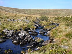 Upper reaches of the West Dart. | |
| Location | |
| Country | England |
| County | Devon |
| Physical characteristics | |
| Source | |
| • location | 50°37′05″N 3°58′41″W / 50.618°N 3.978°W |
| • elevation | 540 m (1,770 ft) |
| Mouth | Dartmeet 50°32′42″N 3°52′37″W / 50.545°N 3.877°W |
• elevation | 210 m (690 ft) |
| Length | 16.25 km (10.10 mi) |

The West Dart River is one of the two main tributaries of the River Dart in Devon, England.
Its source is about 2 km north of Rough Tor on north Dartmoor. It flows south to Two Bridges, then south east past Hexworthy to meet the East Dart River at Dartmeet.
On the left bank of the river about a mile above Two Bridges is the broadleaved Wistman's Wood, "fascinating high-level woods that are quite unlike anywhere else".[1]
Tributaries include the Cowsic River which rises near Devils Tor and flows south below Lydford Tor, to join the West Dart at Two Bridges. Other right bank tributaries include the Blackbrook River, River Swincombe and the O Brook. The Cherry Brook joins the West Dart on the left bank near Sherberton.
References[]
- Ordnance Survey 1:25,000 scale map of Dartmoor. OL28.
- Hemery, Eric (1983). "West Dart Country". High Dartmoor. London: Robert Hale. pp. 404–474. ISBN 0-7091-8859-5.
| Wikimedia Commons has media related to West Dart River. |
This Devon location article is a stub. You can help Wikipedia by . |
- Rivers of Devon
- Dartmoor
- River Dart
- West Dart catchment
- Devon geography stubs
- England river stubs