River Dee (Ireland)
| River Dee | |
|---|---|
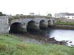 Annagassan Bridge, where the R166 crosses the Dee | |
| Etymology | Irish níth, "combat" |
| Native name | An Níth (Irish) |
| Location | |
| Country | Ireland |
| Cities | Nobber, Ardee, Annagassan |
| Physical characteristics | |
| Source | |
| • location | Teevurcher, County Meath |
| Mouth | |
• location | Irish Sea at Annagassan via Dundalk Bay |
| Length | 60.4 km (37.5 mi) |
| Basin size | 392 km2 (151 sq mi) |
| Discharge | |
| • average | 27.16 m3/s (959 cu ft/s) |
| Basin features | |
| Tributaries | |
| • left | River Glyde |
The River Dee (Irish: An Níth)[1] is a river in eastern Ireland, flowing from County Cavan to join the Glyde in County Louth.[2][3]
Legend[]
In the Táin Bó Cúailnge, Cúchulainn fights at Ath Carpat ("chariot ford") on the river Níth.[4] This takes its name from the Irish níth, meaning "combat".[5] The modern name Dee derives from the town of Ardee (Baile Átha Fhirdhia, "town of Ferdiad's ford").
Course[]
The River Dee springs near Bailieboro in County Cavan and flows in an easterly direction for 37.75 miles (60.75 km)[6] through County Meath and County Louth before entering the River Glyde at the village of Annagassan. The Dee in turn has three main tributaries: the Killary River which joins south of Drumconrath, County Meath, the Gara River which joins west of Ardee, County Louth, and the White River which joins north of Dunleer, County Louth. There is one lake on the Dee called Whitewood Lake which is near Nobber, County Meath.
Wildlife[]
The River Dee is a brown trout fishery.[7]
See also[]
References[]
- ^ "River Dee / An Níth". logainm.ie. Retrieved 4 May 2016.
- ^ "Louth". Atlas and Cyclopedia of Ireland, 1900. Retrieved 12 October 2020 – via libraryireland.com.
- ^ "North Western - Neagh Bann CFRAM Study UoM 06 Hydrology Report" (PDF). cfram.ie. 2015. Archived from the original (PDF) on 13 January 2017.
- ^ "The Tain Bo Culaigne - The Proposals". celtic-twilight.com. Archived from the original on 12 October 2015. Retrieved 8 May 2016.
- ^ "Dictionary of the Irish Language - Search - Níth". Royal Irish Academy. Retrieved 12 October 2020.
- ^ Ordnance Survey of Ireland: Rivers and their Catchment Basins 1958 (Table of Reference)
- ^ "The River Dee". fishinginireland.info. Angling Ireland. Retrieved 12 October 2020.
Coordinates: 53°53′N 6°21′W / 53.883°N 6.350°W

This article related to the geography of County Meath, Ireland is a stub. You can help Wikipedia by . |
This article related to the geography of County Louth, Ireland is a stub. You can help Wikipedia by . |
- Rivers of County Louth
- Rivers of County Meath
- Ireland geography stubs
- Ireland river stubs