River Sett
| River Sett | |
|---|---|
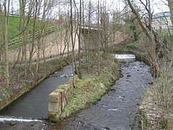 The Sett passes under the A624 Hayfield "bypass". The tower of St. Matthew's church can be seen through the trees in the background, and in the foreground are the scanty remains of Walk Mill. | |
 The River Sett is highlighted in red Coordinates: 53°21′52″N 2°00′00″W / 53.36440°N 1.99990°W | |
| Location | |
| Country | England |
| Physical characteristics | |
| Source | |
| • location | Kinder Scout |
| • elevation | c.540 metres (1,770 ft)[1] |
| Mouth | |
• location | River Goyt |
• elevation | c.130 metres (430 ft)[1] |
| Length | 16.876 kilometres (10.486 mi) |
| Basin size | 47.143 square kilometres (18.202 sq mi) |
| Basin features | |
| Tributaries | |
| • right | River Kinder |


The River Sett is a river that flows through the High Peak borough of Derbyshire, in north western England. It rises near Edale Cross on Kinder Scout and flows through the villages of Hayfield and Birch Vale to join the River Goyt at New Mills.[1] The River Goyt is one of the principal tributaries of the River Mersey. In the past, the river was known as the River Kinder; the modern River Kinder is a right tributary of the Sett, joining the river at Bowden Bridge above Hayfield.[2]
The 2.5-mile Sett Valley Trail follows the trackbed of the former railway line along the valley between Hayfield and New Mills.[3]
The river's Environment Agency pollution classification changed from good to moderate in 2014.[4]
Tributaries[]
- Hidebank Brook ? (L)
- Thornsett/Rowarth Brook ? (R)
- Gibb Brook ? (L)
- Raens Brook (L)
- Birch Hall Brook ? (L)
- Hollingworth Clough ? (R)
- Middle Brook ? (L)
- Phoside Brook ? (L)
- Foxholes Clough (L)
- Hazlehurst Brook (L)
- River Kinder (R)
- Upper Brook ? (L)
- William Clough ? (R)
- Blackshaws Brook ? (L)
- Red Brook (L)
- Coldwell Clough (R)
- Dimpus Clough (L)
- Oaken Clough (R)
See also[]
- List of mills on the River Sett
References[]
- ^ a b c The Peak District: Dark Park Area (OS Explorer Map), vol. OL1, Southampton: Ordnance Survey, 2009-02-02, ISBN 978-0-319-24067-0
- ^ Lewis, Samuel, ed. (1848). "A Topographical Dictionary of England". pp. 394–398. Retrieved 18 April 2018.
The Kinder derives its source from the mountain of Kinder-Scout, and, separating the county of Derby from that of Chester, falls into the river Guyt at a place called the Tor.
- ^ Sett Valley Trail (leaflet produced by Derbyshire County Council Environmental Services Department)
- ^ "Catchment Data Explorer". environment.data.gov.uk. Retrieved 2019-08-14.
Derbyshire Portal | |
| Unitary authorities | |
| Boroughs or districts | |
| Major settlements |
|
| Rivers | |
| Topics | |
| |
Route map:
| ( • help)
|
This Derbyshire location article is a stub. You can help Wikipedia by . |
- Rivers of Derbyshire
- Rivers and valleys of the Peak District
- Goyt catchment
- High Peak, Derbyshire
- Derbyshire geography stubs
- England river stubs