Robertsport
Robertsport | |
|---|---|
 | |
 Robertsport Location in Liberia | |
| Coordinates: 6°45′N 11°22′W / 6.750°N 11.367°W | |
| Country | |
| County | Grand Cape Mount County |
| District | Commonwealth District |
| Population (2008) | |
| • Total | 3,933 |
| Climate | Am |

Robertsport is a town in western Liberia, about 10 miles from the Sierra Leone border. It is named after Joseph Jenkins Roberts, the first president of Liberia.[1]
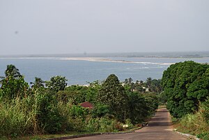
The town lies on Cape Mount peninsula, a spit of land separating the brackish lagoon Lake Piso from the Atlantic Ocean,[2] 50 mi (80 km) north-west of Monrovia. It serves as the capital of Grand Cape Mount County and is the home of the city corporation.[3]
Demographics[]
As of the 2008 census, Robertsport has a population of 3,933. Of this, 1,994 were male and 1,939 female.[4]
History[]
In the mid-15th century, the Portuguese navigator Pedro de Sintra reached the cape, a 1,000-foot high granite promontory, which he named Cabo do Monte (Cape Mount).[1] Cape Mount was the site of Dutch trading post, which turned out to be very hard to defend. The post never became self-sufficient, and habitually required assistance from the station at Elmina, about 750 miles away by sea.[5] Théodore Canot, a writer and slave-trader, established a settlement in the area in 1840.[6] In 1849 the Liberian government signed a treaty with the Vai people,[1] acquiring the territory of Cape Mount and subsequently founding Robertsport in 1856.[6]
Robertsport used to host the , which was built in 1964 to commemorate William V.S. Tubman's sixty-ninth birthday.[7] The institution was meant to be a world-wide center of research,[8] and to support and promote African studies.[7] The civil war destroyed the structure, and only the ruins remain.[9]
It was an Allied Forces Air Force base in World War II and later became a seaside resort known for surfing.[citation needed]
Geography[]
Robertsport's coast contains five point breaks, including three main points known for surfing: Fisherman's Point, closest to town; Cotton Trees; and Cassava Point.[contradictory][10]
In 2009, Liberia's surfer, Alfred Lomax, took a reporter to see what he considered the best surfing spots, "'This here,' he says pointing out to the waves surging down the beach, 'we call this Camp Point. Then, up the beach, is Cutting Point — that’s where they break both ways.'"[11]
Nearby towns and villages include (0.6 nm), (0.3 nm), Bombotown (0.3 nm) and (0.3 nm).[citation needed]
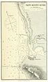
Map of Robertsport (1884)

Cape Mount Bay

Mount Zion Baptist Church

Beach
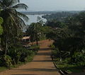
Hillside view

Port of Fanti Town


Town life[]
Liberia is a war torn country. Despite looting, the town has remained structurally intact. The town's architecture includes now-decrepit, plantation-style houses reminiscent of the Southern United States - a historical influence on Liberia - which line wide avenues that lean against the hills on the town's edge.[10]
Robertsport residents are mainly rice farmers and fishermen,[1] with 30% of the population engaging in fishing.[12]
The town is featured in the independent documentary film , which follows four young surfers to war-torn Liberia in search of perfect waves. The film also explores the country's social and political unrest.[13]
Climate[]
| hideClimate data for Robertsport | |||||||||||||
|---|---|---|---|---|---|---|---|---|---|---|---|---|---|
| Month | Jan | Feb | Mar | Apr | May | Jun | Jul | Aug | Sep | Oct | Nov | Dec | Year |
| Average high °C (°F) | 31 (88) |
32 (89) |
32 (90) |
32 (89) |
32 (89) |
29 (85) |
27 (80) |
27 (80) |
28 (82) |
29 (85) |
31 (87) |
31 (87) |
30 (86) |
| Average low °C (°F) | 22 (71) |
22 (72) |
23 (73) |
23 (74) |
23 (74) |
23 (73) |
23 (73) |
22 (71) |
22 (72) |
22 (72) |
22 (72) |
22 (71) |
22 (72) |
| Average precipitation mm (inches) | 38 (1.5) |
5.1 (0.2) |
18 (0.7) |
180 (7.1) |
250 (10) |
490 (19.1) |
800 (31.6) |
930 (36.5) |
930 (36.5) |
370 (14.6) |
110 (4.5) |
84 (3.3) |
4,210 (165.6) |
| Source: Weatherbase [14] | |||||||||||||
Notable residents[]
- Victoria Tolbert (1916–1997), Former First Lady of Liberia[15]
References[]
- ^ Jump up to: a b c d "Robertsport", Britannica Online Encyclopedia
- ^ Robertson, Peter (2001). Important Bird Areas in Africa and associated islands: Priority sites for conservation (PDF). Newbury and Cambridge: Pisces Publications and BirdLife International. p. 479. ISBN 1-874357-20-X. Retrieved 18 February 2019.
- ^ "Grand Cape Mount County Development Agenda" (PDF). mia.gov.lr. p. 6. Retrieved 18 February 2019.
- ^ "2008 National Population and Housing Census: Preliminary Results" (PDF). Liberia Institute of Statistics and Geo-Information Services. Government of the Republic of Liberia. June 2008. Retrieved 2008-11-15.
- ^ Lawrence, A.W. (1963). Trade Castles & Forts of West Africa. London: Jonathan Cape. pp. 41, 57.
- ^ Jump up to: a b Dunn, Elwood E.; Beyan, Amos J.; Burrowes, Carl Patrick (20 December 2000). Historical Dictionary of Liberia (2 ed.). Scarecrow Press. p. 147. ISBN 978-0810838765. Retrieved 18 February 2019.
- ^ Jump up to: a b Zetterström, Kjell (1968). "The Tubman Center of African Culture". Liberian Studies Journal. 1 (1): 73–74. Retrieved 18 February 2019.
- ^ Girma, Kidane (1982). "The National Museum: Liberia - (mission)". Participation and Cooperation for Development Programmes and International Campaigns. UNESCO. 4: 3. Retrieved 18 February 2019.
- ^ "Tubman Center of African Culture | Robertsport, Liberia Attractions". Lonely Planet. Retrieved 18 February 2019.
- ^ Jump up to: a b Thomas, Kate (October 2007). "Surfing Liberia". Lonely Planet. Archived from the original on 4 September 2008. Retrieved 18 February 2019.
- ^ Leitch, Luke. "Alfred Lomax: the man who could be Liberia's first professional surfer." The Times (London). May 27, 2009
- ^ "Grand Cape Mount County Development Agenda". mia.gov.lr. p. 19. Retrieved 18 February 2019.
- ^ Sliding Liberia website
- ^ "Weatherbase: Historical Weather for Robertsport, Liberia". Weatherbase. 2011. Retrieved on November 24, 2011.
- ^ Dunn, Elwood D.; Beyan, Amos J.; Burrowes, Carl Patrick (2000). Historical Dictionary of Liberia. pp. 323–324.
External links[]
| Wikivoyage has a travel guide for Robertsport. |
![]() Media related to Robertsport at Wikimedia Commons
Media related to Robertsport at Wikimedia Commons
Coordinates: 6°45′N 11°22′W / 6.750°N 11.367°W
| show Authority control |
|---|
- Grand Cape Mount County
- County capitals in Liberia
- Roberts family (Liberia)