Rockford, Michigan
Rockford, Michigan | |
|---|---|
 Downtown Rockford in 2019 | |
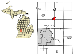 Location of Rockford, Michigan | |
| Coordinates: 43°7′20″N 85°33′32″W / 43.12222°N 85.55889°W | |
| Country | United States |
| State | Michigan |
| County | Kent |
| Area | |
| • Total | 3.29 sq mi (8.52 km2) |
| • Land | 3.22 sq mi (8.35 km2) |
| • Water | 0.07 sq mi (0.17 km2) |
| Elevation | 702 ft (214 m) |
| Population | |
| • Total | 5,719 |
| • Estimate (2019)[5] | 6,391 |
| • Density | 1,982.32/sq mi (765.47/km2) |
| Time zone | UTC-5 (Eastern (EST)) |
| • Summer (DST) | UTC-4 (EDT) |
| ZIP codes | 49341, 49351 |
| Area code(s) | 616 |
| FIPS code | 26-69080[3] |
| GNIS feature ID | 0636089[4] |
| Website | www |

Rockford is a small city in Kent County in the U.S. state of Michigan. As of the 2010 census, the city population was 5,719. It is on the Rogue River and is 14 miles north of Grand Rapids.
Geography[]
Rockford occupies/has annexed land formerly governed by the following townships:
According to the United States Census Bureau, the city has a total area of 3.31 square miles (8.57 km2), of which, 3.24 square miles (8.39 km2) is land and 0.07 square miles (0.18 km2) is water.[6]
Transportation[]
- Indian Trails provides daily intercity bus service between Grand Rapids, Michigan and St. Ignace.[7]
Demographics[]
| Historical population | |||
|---|---|---|---|
| Census | Pop. | %± | |
| 1870 | 582 | — | |
| 1880 | 816 | 40.2% | |
| 1900 | 711 | — | |
| 1910 | 843 | 18.6% | |
| 1920 | 1,148 | 36.2% | |
| 1930 | 1,613 | 40.5% | |
| 1940 | 1,773 | 9.9% | |
| 1950 | 1,937 | 9.2% | |
| 1960 | 2,074 | 7.1% | |
| 1970 | 2,428 | 17.1% | |
| 1980 | 3,324 | 36.9% | |
| 1990 | 3,750 | 12.8% | |
| 2000 | 4,626 | 23.4% | |
| 2010 | 5,719 | 23.6% | |
| 2019 (est.) | 6,391 | [5] | 11.8% |
| U.S. Decennial Census[8] | |||
2010 census[]
As of the census[2] of 2010, there were 5,719 people, 2,201 households, and 1,537 families living in the city. The population density was 1,765.1 inhabitants per square mile (681.5/km2). There were 2,302 housing units at an average density of 710.5 per square mile (274.3/km2). The racial makeup of the city was 95.0% White, 0.7% African American, 0.5% Native American, 1.2% Asian, 0.1% Pacific Islander, 0.7% from other races, and 2.0% from two or more races. Hispanic or Latino of any race were 3.7% of the population.
There were 2,201 households, of which 42.1% had children under the age of 18 living with them, 51.7% were married couples living together, 13.7% had a female householder with no husband present, 4.5% had a male householder with no wife present, and 30.2% were non-families. 26.7% of all households were made up of individuals, and 10.7% had someone living alone who was 65 years of age or older. The average household size was 2.58 and the average family size was 3.16.
The median age in the city was 33.7 years. 30.9% of residents were under the age of 18; 7% were between the ages of 18 and 24; 27.8% were from 25 to 44; 23.6% were from 45 to 64; and 10.7% were 65 years of age or older. The gender makeup of the city was 47.4% male and 52.6% female.
The median income for a household in the city was $53,113, and the median income for a family was $71,700. Males had a median income of $62,015 versus $33,325 for females. The per capita income for the city was $28,632. About 10.5% of families and 11.7% of the population were below the poverty line, including 18.5% of those under age 18 and 7.2% of those age 65 or over.
2000 census[]
As of the census[3] of 2000, there were 4,626 people, 1,741 households, and 1,255 families living in the city. The population density was 1,544.2 per square mile (595.4/km2). There were 1,796 housing units at an average density of 599.5 per square mile (231.1/km2). The racial makeup of the city was 96.20% White, 0.61% African American, 0.39% Native American, 0.91% Asian, 0.02% Pacific Islander, 0.63% from other races, and 1.25% from two or more races. Hispanic or Latino of any race were 1.51% of the population.
There were 1,741 households, out of which 45.7% had children under the age of 18 living with them, 54.1% were married couples living together, 14.9% had a female householder with no husband present, and 27.9% were non-families. 25.3% of all households were made up of individuals, and 11.3% had someone living alone who was 65 years of age or older. The average household size was 2.65 and the average family size was 3.21.
In the city, the population was spread out, with 33.9% under the age of 18, 7.1% from 18 to 24, 33.0% from 25 to 44, 17.1% from 45 to 64, and 9.0% who were 65 years of age or older. The median age was 32 years. For every 100 females, there were 92.6 males. For every 100 females age 18 and over, there were 80.9 males.
The median income for a household in the city was $50,562, and the median income for a family was $55,954. Males had a median income of $45,847 versus $28,024 for females. The per capita income for the city was $19,906. About 8.4% of families and 8.1% of the population were below the poverty line, including 10.7% of those under age 18 and 12.9% of those age 65 or over.
Local culture[]
The White Pine Trail runs through the downtown area of Rockford, next to the Rogue River and the Rockford Dam.[9] The downtown area hosts a summer farmer's market on Saturday.[10] The city hosts a Fall Harvest Festival.[11] The Rockford Historical Society also hosts events.
Start of Summer Celebration is a community organization annually held in early June to kick off the summer. Start of Summer is a fair that includes a fireworks, carnival rides, live music, food trucks, a craft fair, and even a fire truck pull. It's a staple in the community that everyone looks forward to![12]
The Rockford High School Marching Band has become well known by winning the title of MCBA flight 1 State Champions 3 consecutive times in 2017, 2018 and 2019. Under the direction of Brian Phillips, they also had the honor of performing in the Macy's Thanksgiving Day Parade in 2017.[citation needed]
Education[]
Rockford is served by the Rockford Public Schools.
Rockford Christian School, a campus of Grand Rapids Christian Schools, is in Rockford.[13]
Industry[]
Wolverine Worldwide has had major operations in the city for over 100 years. In modern times, its former tannery site used Scotchgard chemicals to waterproof shoes, which contaminated local areas with the active ingredients at the time of PFOA and PFOS.[14][15]
Notable people[]
- Brent Bookwalter, cyclist and participant in 2010 Tour de France
- Andrew Britton, author
- Parker Ehinger, lineman for NFL's Kansas City Chiefs
- Jason Hartmann, distance runner, 4th-place finisher in 2012 Boston Marathon
- Adam Kieft, lineman with NFL's Cincinnati Bengals
- Julia A. Moore, poet
- Dathan Ritzenhein, Olympic distance runner, former American 5k record holder
- John C. Sjogren, Army soldier and Medal of Honor recipient in World War II
- Joe Staley, left tackle for San Francisco 49ers
- Dick York, actor, best known for playing Darrin Stephens on 1960s sitcom Bewitched
- Ginger Zee, meteorologist for ABC News and Good Morning America.
See also[]
References[]
- ^ "2019 U.S. Gazetteer Files". United States Census Bureau. Retrieved July 25, 2020.
- ^ Jump up to: a b U.S. Census website, United States Census Bureau, retrieved 2012-11-25
- ^ Jump up to: a b U.S. Census website, United States Census Bureau, retrieved 2008-01-31
- ^ US Board on Geographic Names, United States Geological Survey, 2007-10-25, retrieved 2008-01-31
- ^ Jump up to: a b "Population and Housing Unit Estimates". United States Census Bureau. May 24, 2020. Retrieved May 27, 2020.
- ^ US Gazetteer files 2010, United States Census Bureau, archived from the original on 2012-01-25, retrieved 2012-11-25
- ^ Grand Rapids-Cadillac-Traverse City-St. Ignace (PDF), Indian Trails, January 15, 2013, retrieved 24 May 2020
- ^ Census of Population and Housing, Census.gov, retrieved June 4, 2015
- ^ "10 great Outdoor Dining spots along the White Pine Trail". mlive. 2021-02-09. Retrieved 2021-06-24.
- ^ "2021 summer guide to outdoor social districts in Michigan". mlive. 2021-05-31. Retrieved 2021-06-24.
- ^ Dewey, Charlsie (2017-09-22). "Rockford Brewing Pitches Tent at Harvest Festival". Grand Rapids Magazine. Retrieved 2021-06-24.
- ^ "Rockford Start of Summer Celebration returns this weekend". WOODTV.com. 2021-06-10. Retrieved 2021-06-24.
- ^ Schools, Grand Rapids Christian Schools, retrieved 2019-11-24
- ^ "About", We are Wolverine, Wolverine Worldwide, retrieved 4 August 2019
- ^ Ellison, Garret (May 6, 2018), Wolverine tannery back in EPA crosshairs 5 years later, MLive Media Group, retrieved 4 August 2019
External links[]
- Rockford official website
- History and directory of Kent County, Michigan. Dillenback & Leavitt. Grand Rapids, Mich.: Daily eagle steam printing house, 1870. pp. 25+.
| show Municipalities and communities of Kent County, Michigan, United States |
|---|

| show Authority control |
|---|
Coordinates: 43°07′12″N 85°33′36″W / 43.12000°N 85.56000°W
- Cities in Kent County, Michigan
- Grand Rapids metropolitan area
- 1866 establishments in Michigan
- Populated places established in 1866