Rometta
Rometta
Ρομέττα (Greek) | |
|---|---|
| Comune di Rometta | |
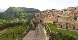 Skyline | |
show Location of Rometta | |
 Rometta Location of Rometta in Italy | |
| Coordinates: 38°10′N 15°25′E / 38.167°N 15.417°ECoordinates: 38°10′N 15°25′E / 38.167°N 15.417°E | |
| Country | Italy |
| Region | Sicily |
| Metropolitan city | Messina (ME) |
| Frazioni | Rometta Marea, Gimello, Mazzabruno, Santa Domenica, Rapano, San Cono, Sotto Castello, S. Andrea |
| Government | |
| • Mayor | Nicola Merlino |
| Area | |
| • Total | 32.5 km2 (12.5 sq mi) |
| Elevation | 560 m (1,840 ft) |
| Population (30 November 2012)[3] | |
| • Total | 6,532 |
| • Density | 200/km2 (520/sq mi) |
| Demonym(s) | Romettesi |
| Time zone | UTC+1 (CET) |
| • Summer (DST) | UTC+2 (CEST) |
| Postal code | 98043 |
| Dialing code | 090 |
| Patron saint | St. Leo of Catania |
| Saint day | 20 February |
| Website | Official website |


Rometta (Sicilian: Ramietta) is a comune (municipality) in the Metropolitan City of Messina in the Italian region Sicily, located about 180 kilometres (110 mi) east of Palermo and about 12 kilometres (7 mi) west of Messina. It was the last bastion of Sicily controlled by the Eastern Roman Empire (Byzantium), and falling only in 965 to the Kalbids' Muslim army in the Siege of Rometta.

Rometta borders the following municipalities: Messina, Monforte San Giorgio, Roccavaldina, Saponara, Venetico, Spadafora.
References[]
- ^ "Superficie di Comuni Province e Regioni italiane al 9 ottobre 2011". Istat. Retrieved 16 March 2019.
- ^ "Popolazione Residente al 1° Gennaio 2018". Istat. Retrieved 16 March 2019.
- ^ All demographics and other statistics: Italian statistical institute Istat.
External links[]
| Authority control |
|---|
This Sicilian location article is a stub. You can help Wikipedia by . |
Categories:
- Cities and towns in Sicily
- Municipalities of the Metropolitan City of Messina
- Sicily geography stubs