Rote Ndao Regency
Rote Ndao Regency
Kabupaten Rote Ndao | |
|---|---|
Regency | |
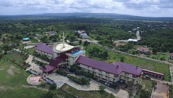 Ba'a, regency seat of Rote Ndao from above | |
 Coat of arms | |
 Location within East Nusa Tenggara | |
 Rote Ndao Regency Location in Lesser Sunda Islands and Indonesia | |
| Coordinates: 10°28′00″S 123°23′00″E / 10.4667°S 123.3833°ECoordinates: 10°28′00″S 123°23′00″E / 10.4667°S 123.3833°E | |
| Country | |
| Region | Lesser Sunda Islands |
| Province | |
| Capital | Baa |
| Government | |
| • Regent | Leonard Haning |
| • Vice Regent | Jonas. C. Lun |
| Area | |
| • Land | 495.91 sq mi (1,284.41 km2) |
| Population (2020 Census)[1] | |
| • Total | 143,764 |
| Area code | (+62) 380 |
| HDI (2020) | |
| Website | rotendaokab.go.id |


Rote Ndao Regency is a regency in East Nusa Tenggara province of Indonesia, consisting primarily of the island of Rote, situated south-west of the western tip of West Timor, together with minor offshore islands. The regency seat is in Ba'a, which situated on Lobalain district. The population was 119,908 as of the 2010 census and 147,379 at the 2015 Intermediate Census,[3] while the 2020 Census revealed a total of 143,764.[1]
History[]
Established in 2002 under Law (Undang-Undang) RI No.9 dated 10 April 2002, it was previously a part of Kupang Regency.[4]
On 1962, it was divided into 4 districts; West, East, South, and Central Rote. Later on 1967 it was split into 8 districts to fulfill requirements to became an independent regency. This goal was finally realized in 2002 after central government pressurised by around 300 cultural figures from 19 traditional regions in the area.[4]
Infrastructure[]
There are 542,48 kilometers of road in the regency, from which 314,745 kilometers have been paved with asphalt as of 2020.[5] The regency is served by David Constantijn Saudale Airport with 1,200 meters of a single runway, located around 7 kilometers from the regency seat.[6]
There are four ports in the regency, the biggest and busiest being Ba'a Port, which handled 55% of the region's ship traffic in 2019.[5] Ba'a Port is also connected to president Joko Widodo's sea toll program route TL13 which aimed to reduce development and economic gap between isolated regions.[7][8] Government of Indonesia also constructed a laboratorium and quarantine facility in the port on 2019 as part of massive expansions of the port.[8]
The regency has one regional hospital owned by government of the regency, in addition of 12 puskesmas, 381 healthcare centers, 14 maternity cottages, and four pharmacies.[6] The regional hospital, Ba'a Regional Hospital is located on regency seat. It is classified as D class hospital by Indonesian Ministry of Health.[9] Education facilities in the regency consist of 65 kindergartens, 145 elementary schools, 53 junior highschools, 10 senior highschools, 5 vocational highschools, and one special education school. There's also one higher education institution, .[6][10]
There are exactly 456 Protestant churches, 13 Catholic churches, 11 mosques, and one Hindu temple.[5][6] As of 2020, most of the regency has access to 4G internet services and other telecommunication services.[11] The only fiber optic service provider in the regency is IndiHome, which is state-owned under Telkomsel.[12]
Economy[]
Main economic activities in the region as of 2019 was agriculture.[5] There are 22,684 ha of paddy fields in the regency. 50.36% of the regency's workforce work on agriculture sector and contributes to 47.12% of regency's economy. Another important commodity is red onion, which the regency produced 34,257 quintals of it on 2019. Other commodities such as coconut and guava also exist, which the regency's produced 3,445 tons and 45 tons in order.[5] Mining and energy sector contributes around 12% to regency's economy as of 2019. Food processing industry also have established presence in the region and employed around 5,000 workers as of 2019.[5]
Tourism is a small but growing sector in the regency.[5] There were 21 homestays and 33 hotels in varying quality of service on the regency as of 2019.[5] In the same year, the regency was visited by exactly 4,988 tourists, whom more than half of it came from abroad. This was an increase from 2018, which the regency saw 3,861 tourists visiting the region.[5]
Economic growth was 5.23% on 2019, a slight decrease from previous year with 5.42%. The fastest growing sector was natural gas and energy with increase of 18% on the same year.[5][13] At the same time, unemployment rate was 2.03%.[13]
Geography[]
The regency is surrounded by water, bordering the Savu Sea to the north, the Indian Ocean to the south and west, and the to the east. It is composed of 107 islands, 8 of which are inhabited and 99 are uninhabited.[4] The topography varies from flat make up 35% of its territory to hills around 25%, from 0 to 1,500 meters above sea level. Around 60% of its territory are 200 meters above sea level.[4]
Administration[]
This Regency was originally composed of six districts (kecamatan), but it later underwent re-organisation into eight districts, and in 2012 into ten districts. Their areas (in km2) and their 2010[14] and 2015 Census populations are listed below,[15] together with the official estimates for mid 2019.[1] The table also includes the number of villages (rural desa and urban kelurahan) in each district, and its postal codes
| Name | English name | Area (in km2) |
Population Census 2010 |
Population Census 2015 |
Population Estimate mid-2019 |
Number of villages |
Post codes |
|---|---|---|---|---|---|---|---|
| [a] | Southwest Rote Island |
114.57 | 19,737 | 24,325 | 28,329 | 19 | 85982 |
| [b] | Northwest Rote Island |
172.40 | 22,608 | 27,864 | 32,451 | 22 | 85981 |
| (Busalangga) | 145.70 | 24,789 | 30,550 | 35,577 | 18 | 85912 - 85918 | |
| Middle Rote | 162.50 | 8,058 | 9,931 | 11,565 | 8 | 85971 | |
| South Rote | 73.38 | 5,173 | 6,375 | 7,424 | 7 | 85972 | |
| Baru Beach | 176.18 | 12,397 | 15,278 | 17,793 | 15 | 85973 | |
| [c] | East Rote | 110.84 | 16,633 | 14,903 | 17,356 | 11 | 85975 |
| Landu Leko | 194.06 | [d] | 5,596 | 6,517 | 7 | 85974 | |
| West Rote | 100.48 | 10,513 | 9,151 | 10,658 | 7 | 85981 & 85982 | |
| Ndao Nuse[e] | 14.19 | [f] | 3,805 | 4,434 | 5 | 85983 | |
| Totals | 1,284.41 | 119,908 | 147,379 | 172,104 | 119 |
References[]
- ^ Jump up to: a b c Badan Pusat Statistik, Jakarta, 2020.
- ^ "Ekonomi". Rote Ndao. Retrieved 2021-04-12.
- ^ Badan Pusat Statistik, Jakarta, 2018.
- ^ Jump up to: a b c d "Profil Daerah | Rote Ndao". Retrieved 2021-04-12.
- ^ Jump up to: a b c d e f g h i j "Kabupaten Rote Ndao Dalam Angka 2020" [Rote Ndao Regency Figures 2020] (PDF). rotendaokab.bps.go.id (in Indonesian). Retrieved 2021-04-12.
- ^ Jump up to: a b c d "Fasilitas | Rote Ndao". Retrieved 2021-04-12.
- ^ "Pengadaan.id | Pelabuhan Ba'a Rote Sebagai Bagian Tol Laut Masih Perlu Ditingkatkan Lagi". www.pengadaan.id. Retrieved 2021-04-12.
- ^ Jump up to: a b "Pelabuhan Ba'a Terus Berbenah | RoteOnline News • Media" (in Indonesian). 2019-11-19. Retrieved 2021-04-12.
- ^ "Informasi SDM Kesehatan Nasional". bppsdmk.kemkes.go.id. Retrieved 2021-04-12.
- ^ "Universitas Nusa Lontar Rote". www.unstarrote.ac.id. Retrieved 2021-04-12.
- ^ "Tak Perlu ke Pesisir Pantai, Kini Warga Desa Ndao Dapat Menikmati Jaringan Kuat Telkomsel Dari Rumah". Bali Tribune. 2020-11-14. Retrieved 2021-04-12.
- ^ "IndiHome Kini Hadir di Pulau Rote". Republika Online (in Indonesian). 2019-09-19. Retrieved 2021-04-12.
- ^ Jump up to: a b "Ekonomi | Rote Ndao". Retrieved 2021-04-12.
- ^ Biro Pusat Statistik, Jakarta, 2011.
- ^ Badan Pusat Statistik, Jakarta, 2019.
Notes[]
- ^ Including 36 offshore islands
- ^ Including 7 offshore islands
- ^ Including 45 offshore islands
- ^ Included in 2010 population of Rote Timur district, from the northern part of which it was cut out in 2012
- ^ Comprising the offshore Ndao Island, Nuse Island and Do'o Island
- ^ Included in 2010 population of Rote Barat district, from which it was cut out in 2012
External links[]
| show Regencies and cities of East Nusa Tenggara |
|---|

| show Authority control |
|---|
- Rote Ndao Regency