Ruston, Washington
Ruston, Washington | |
|---|---|
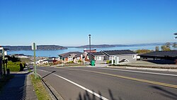 Neighborhoods at Stack Hill | |
 Location of Ruston, Washington | |
| Coordinates: 47°17′49″N 122°30′38″W / 47.29694°N 122.51056°WCoordinates: 47°17′49″N 122°30′38″W / 47.29694°N 122.51056°W | |
| Country | United States |
| State | Washington |
| County | Pierce |
| Area | |
| • Total | 0.26 sq mi (0.67 km2) |
| • Land | 0.26 sq mi (0.66 km2) |
| • Water | 0.00 sq mi (0.01 km2) |
| Elevation | 43 ft (13 m) |
| Population | |
| • Total | 749 |
| • Estimate (2019)[2] | 845 |
| • Density | 3,300.78/sq mi (1,276.60/km2) |
| Time zone | UTC-8 (Pacific (PST)) |
| • Summer (DST) | UTC-7 (PDT) |
| ZIP code | 98407 |
| Area code | 253 |
| FIPS code | 53-60510 |
| GNIS feature ID | 1512629[4] |
| Website | rustonwa.org |

Ruston is a city in Pierce County, Washington, United States. The population was 749 at the 2010 census.
Although it is nearly indistinguishable from the adjacent city of Tacoma, the predominantly residential area still retains its status as a separate municipality long after it ceased to be a company town.[5] The local government opted to reclassify Ruston as a city in late 2012.
History[]
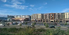
In 1890 industrialist W.R. Rust established Tacoma Smelting & Refining Company and a company town for his employees, naming the place "Smelter", poisoning the ground to this very day.[6] On October 22, 1906, residents voted to change the name to Ruston, in honor of Mr. Rust.[7] Ruston was officially incorporated on November 10, 1906. It is surrounded on one side by Commencement Bay and all other sides the city of Tacoma. The primary industry for decades was the ASARCO copper smelting plant on the waterfront. The smelter and its landmark smokestack, however, were demolished in 1993. A massive Superfund cleanup at the site has been underway since the early 1990s. This area has been renamed "Point Ruston", as a large residential and commercial center on the waterfront is under construction as of 2017, which could add over 1,000 residents to the city.
The Ruston town council passed a measure to become a noncharter code city under Washington law in late 2012. Officials indicated that the "Town of Ruston" moniker will continue to be used, however.[8][9]
Geography[]
Ruston is located at 47°17′49″N 122°30′38″W / 47.29694°N 122.51056°W (47.296906, -122.510513).[10] It is surrounded on three sides by the city of Tacoma. To the north is Puget Sound.
According to the United States Census Bureau, the town has a total area of 0.34 square miles (0.88 km2), of which, 0.26 square miles (0.67 km2) is land and 0.08 square miles (0.21 km2) is water.[11]

Demographics[]
| Historical population | |||
|---|---|---|---|
| Census | Pop. | %± | |
| 1910 | 780 | — | |
| 1920 | 1,128 | 44.6% | |
| 1930 | 818 | −27.5% | |
| 1940 | 739 | −9.7% | |
| 1950 | 838 | 13.4% | |
| 1960 | 694 | −17.2% | |
| 1970 | 668 | −3.7% | |
| 1980 | 612 | −8.4% | |
| 1990 | 693 | 13.2% | |
| 2000 | 738 | 6.5% | |
| 2010 | 749 | 1.5% | |
| 2019 (est.) | 845 | [2] | 12.8% |
| U.S. Decennial Census[12] | |||
2010 census[]
As of the census[3] of 2010, there were 749 people, 336 households, and 194 families living in the town. The population density was 2,880.8 inhabitants per square mile (1,112.3/km2). There were 430 housing units at an average density of 1,653.8 per square mile (638.5/km2). The racial makeup of the town was 87.0% White, 2.9% African American, 1.1% Native American, 2.7% Asian, 0.7% Pacific Islander, 0.9% from other races, and 4.7% from two or more races. Hispanic or Latino of any race were 6.0% of the population.
There were 336 households, of which 28.0% had children under the age of 18 living with them, 43.8% were married couples living together, 9.2% had a female householder with no husband present, 4.8% had a male householder with no wife present, and 42.3% were non-families. 30.1% of all households were made up of individuals, and 6.6% had someone living alone who was 65 years of age or older. The average household size was 2.23 and the average family size was 2.78.
The median age in the town was 39.5 years. 20.8% of residents were under the age of 18; 6.8% were between the ages of 18 and 24; 30.6% were from 25 to 44; 31.7% were from 45 to 64; and 10% were 65 years of age or older. The gender makeup of the town was 48.7% male and 51.3% female.
2000 census[]
As of the census of 2000, there were 738 people, 330 households, and 185 families living in the town. The population density was 2,879.9 people per square mile (1,095.9/km2). There were 355 housing units at an average density of 1,385.3 per square mile (527.2/km2). The racial makeup of the town was 87.26% White, 2.57% African American, 2.98% Native American, 2.30% Asian, 0.14% Pacific Islander, 1.08% from other races, and 3.66% from two or more races. Hispanic or Latino of any race were 3.79% of the population.
There were 330 households, out of which 22.7% had children under the age of 18 living with them, 41.8% were married couples living together, 9.4% had a female householder with no husband present, and 43.9% were non-families. 34.2% of all households were made up of individuals, and 8.5% had someone living alone who was 65 years of age or older. The average household size was 2.24 and the average family size was 2.87.
In the town the age distribution of the population shows 20.1% under the age of 18, 8.7% from 18 to 24, 33.5% from 25 to 44, 27.1% from 45 to 64, and 10.7% who were 65 years of age or older. The median age was 39 years. For every 100 females, there were 106.7 males. For every 100 females age 18 and over, there were 108.5 males.
The median income for a household in the town was $48,393, and the median income for a family was $54,167. Males had a median income of $36,932 versus $36,042 for females. The per capita income for the town was $22,565. About 7.7% of families and 13.1% of the population were below the poverty line, including 12.8% of those under age 18 and 5.1% of those age 65 or over.
References[]
- ^ "2019 U.S. Gazetteer Files". United States Census Bureau. Retrieved August 7, 2020.
- ^ Jump up to: a b "Annual Estimates of the Resident Population for Incorporated Places in Washington: April 1, 2010 to July 1, 2019". United States Census Bureau. May 2020. Retrieved May 27, 2020.
- ^ Jump up to: a b "U.S. Census website". United States Census Bureau. Retrieved 2012-12-19.
- ^ "US Board on Geographic Names". United States Geological Survey. 2007-10-25. Retrieved 2008-01-31.
- ^ "Town of Ruston". Government of the Town of Ruston. Retrieved 2009-03-05.
- ^ https://www.thenewstribune.com/news/local/article43503663.html
- ^ "Ruston". Washington Place Names database. Tacoma Public Library. Archived from the original on 2009-03-09. Retrieved 2009-03-05.
- ^ John Langeler (November 19, 2012). "Town of Ruston grows up". Seattle: KING5.com. Archived from the original on November 28, 2012.
- ^ Matt Misterek (October 2, 2012). "Change from town to city gives Ruston leaders more autonomy". The News Tribune. Tacoma. Archived from the original on November 13, 2012.
- ^ "US Gazetteer files: 2010, 2000, and 1990". United States Census Bureau. 2011-02-12. Retrieved 2011-04-23.
- ^ "US Gazetteer files 2010". United States Census Bureau. Archived from the original on 2012-01-25. Retrieved 2012-12-19.
- ^ United States Census Bureau. "Census of Population and Housing". Retrieved July 25, 2013.
External links[]
| Wikimedia Commons has media related to Ruston, Washington. |
- Official website
- Ruston Documentary produced by Full Focus
| show Municipalities and communities of Pierce County, Washington, United States |
|---|

| show Authority control |
|---|
- Company towns in Washington (state)
- North Tacoma, Washington
- Cities in Pierce County, Washington
- Cities in the Seattle metropolitan area
- Cities in Washington (state)
- Asarco
- 1906 establishments in Washington (state)