Südharz
Südharz | |
|---|---|
 Stolberg Castle in Stolberg | |
 Coat of arms | |
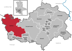
show Location of Südharz within Mansfeld-Südharz district | |
 Südharz | |
| Coordinates: 51°29′N 11°04′E / 51.483°N 11.067°ECoordinates: 51°29′N 11°04′E / 51.483°N 11.067°E | |
| Country | Germany |
| State | Saxony-Anhalt |
| District | Mansfeld-Südharz |
| Government | |
| • Mayor (2016–23) | Ralf Rettig[1] |
| Area | |
| • Total | 236.36 km2 (91.26 sq mi) |
| Elevation | 145 m (476 ft) |
| Population (2020-12-31)[2] | |
| • Total | 9,225 |
| • Density | 39/km2 (100/sq mi) |
| Time zone | UTC+01:00 (CET) |
| • Summer (DST) | UTC+02:00 (CEST) |
| Postal codes | 06536 |
| Dialling codes | 034651, 034653, 034654, 034656, 034658 |
| Vehicle registration | MSH, EIL, HET, ML, SGH |


Südharz (literally "South Harz") is a municipality in the Mansfeld-Südharz district, Saxony-Anhalt, Germany. It was formed on 1 January 2010 by the merger of the former municipalities Agnesdorf, Bennungen, Breitenstein, Breitungen, Dietersdorf, Drebsdorf, Dittichenrode, Hainrode, Hayn, Kleinleinungen, Questenberg, Roßla, Rottleberode, Schwenda and Uftrungen. Wickerode and Stolberg were added in September 2010.
References[]
- ^ Bürgermeisterwahlen in den Gemeinden, Endgültige Ergebnisse, Statistisches Landesamt Sachsen-Anhalt, accessed 8 July 2021.
- ^ "Bevölkerung der Gemeinden – Stand: 31. Dezember 2020" (PDF). Statistisches Landesamt Sachsen-Anhalt (in German). June 2021.
| show Towns and municipalities in the district of Mansfeld-Südharz |
|---|
| show Authority control |
|---|
This Mansfeld-Südharz location article is a stub. You can help Wikipedia by . |
Categories:
- Municipalities in Saxony-Anhalt
- Mansfeld-Südharz
- Province of Saxony
- Bezirk Halle
- Mansfeld-Südharz geography stubs