SAO Eastern Slavonia, Baranja and Western Syrmia
Serbian Autonomous Oblast of Eastern Slavonia, Baranja and Western Syrmia
| |||||||||
|---|---|---|---|---|---|---|---|---|---|
| 1991–1992 | |||||||||
 Flag
 Coat of arms
| |||||||||
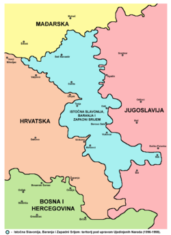 Eastern Slavonia, Baranja and Western Syrmia (cyan) | |||||||||
| Status | Self-proclaimed insurgent entity | ||||||||
| Capital | Vukovar | ||||||||
| Government | Interim authority | ||||||||
| Speaker of the People's Assembly | |||||||||
• 1991–1992 | |||||||||
| Historical era | Breakup of Yugoslavia | ||||||||
• Broke away from Croatia | 25 June 1991 | ||||||||
• Incorporated into the Republic of Serbian Krajina | 26 February 1992 | ||||||||
| Currency | Krajina dinar | ||||||||
| |||||||||
Sources: www.worldstatesmen.org | |||||||||
| History of Slavonia |
|---|
 |
The Serbian Autonomous Oblast of Eastern Slavonia, Baranja and Western Syrmia (Croatian: Srpska autonomna oblast Istočna Slavonija, Baranja i Zapadni Srijem; Serbian Cyrillic: Српска аутономна област Источна Славонија, Барања и Западни Срем / Serbian Latin: Srpska autonomna oblast Istočna Slavonija, Baranja i Zapadni Srem) was a self-proclaimed Serbian Autonomous Oblast (SAO) in eastern Croatia, established during the Yugoslav Wars. It was one of three SAOs proclaimed on the territory of Croatia. The oblast included parts of the geographical regions of Slavonia, Baranja and Syrmia.
The entity was formed on June 25, 1991, the same day the Socialist Republic of Croatia decided to withdraw from Yugoslavia, following the Croatian independence referendum, 1991. In the first phase of the Croatian War of Independence, in 1992, the oblast joined the breakaway Republic of Serbian Krajina (RSK). After the fall of Republic of Serbian Krajina in 1995, there was a short-lived Serb parallel entity Eastern Slavonia, Baranja and Western Syrmia that existed in the same area and was reintegrated with the rest of country after the signing of Erdut Agreement and the end of the United Nations Transitional Administration for Eastern Slavonia, Baranja and Western Sirmium in 1998.
History[]
On January 7, 1991 a group of political leaders of local Serbs from eastern regions of Croatia decided to create a regional political body, called the "Serbian National Council of Slavonia, Baranja and Western Syrmia". The SAO Eastern Slavonia, Baranja and Western Syrmia was declared on June 25, 1991, and on June 26 its first president was declared to be Goran Hadžić. Like the SAO Krajina, it was developed by the Serbian National Council, but was the one representing Eastern Slavonia, Baranja and Western Syrmia.
Initially, it was a separate Serb autonomous region (oblast), but it subsequently joined the Republic of Serbian Krajina (RSK) in February 1992.[1] Its borders were established by the end of 1991 as entrenched front lines of the first phase of the Croatian War of Independence. Up to August 1995, Eastern Slavonia, Baranja and Western Syrmia was de facto part of the Republic of Serbian Krajina, while de jure still part of Croatia, per United Nations Security Council Resolution 753. The region did not have its own local/regional administration within the RSK.
Geography[]
The territory of the former SAO Eastern Slavonia, Baranja and Western Syrmia was part of the Central European Pannonian Basin. The eastern border of the oblast was mostly the Danube river, while approximately one third of the western border was the Drava river. The Kopački rit natural preserve located near the confluence of Drava and Danube formed a major geographical barrier - there were no road or rail connections between Baranja and the southern parts of the territory, except through Serbia.
Other boundaries were not natural boundaries: the border with Hungary in the north had existed since the Kingdom of Serbs, Croats and Slovenes, the eastern border with FR Yugoslavia partly existed since the Kingdom of Slavonia (on the Danube) and was partly set with the formation of SFR Yugoslavia, while the border with the rest of Croatia in the west and south was formed after the fronts were settled in the first phase of the Croatian War of Independence.
Eastern Slavonia is a mostly flat area, with the best type of soil where agriculture is highly developed, particularly on wheat fields, and it also has several forests as well as vineyards.
The Đeletovci Oil fields are located between the villages of Đeletovci, Banovci and Nijemci.
Traffic over the Brotherhood and Unity Highway (today the A3) was interrupted with the formation of the ESBWS. The water transport over the Danube river continued unobstructed. The Drava river was not navigated at the time. The railway line between Zagreb and Belgrade and the transport between the Budapest and Sarajevo passing through the area were also closed.
Population[]
The population of this area was ethnically mixed. Before the war, the total population of the area numbered 192,163 inhabitants, and was composed of:
- 90,454 (47%) Croats,
- 61,492 (32%) Serbs, and
- 40,217 (21%) others (Hungarians, Roma, Yugoslavs, Germans, Rusyns, Slovaks, etc.).
During the Croatian War of Independence, 109,500 Serbs lived in this area out of a total of 160,000.[2][better source needed] which means that the number of Serbs living there has almost doubled while the general population has decreased
War crimes charges brought by the International Criminal Tribunal for the former Yugoslavia against Croatian Serb leader in the region, Goran Hadžić, indicate that virtually all Croat and other non-Serb population of the region was either killed, deported or otherwise forcibly removed from the area.[3]
Municipalities and Inhabited places[]
During the existence of the Republic of Serbian Krajina, the region was divided into five municipalities:
- Beli Manastir (in Baranja),
- Dalj and Tenja (in eastern Slavonia), and
- Vukovar and Mirkovci (in western Syrmia).
The main cities in the area were Vukovar and Beli Manastir. Other important places included Borovo Selo, Darda, Dalj, Ilok, and Tenja.
Legacy[]
After the RSK's demise in August 1995, the region was reconstituted again as Eastern Slavonia, Baranja and Western Syrmia (1995-1998).
Following the November 1995 Erdut Agreement, it was subsequently controlled by the United Nations Transitional Administration for Eastern Slavonia, Baranja and Western Sirmium
After the war, all the towns and municipalities in the region were designated Areas of Special State Concern. Today the ethnic Serb interests in the region are advocated by the Joint Council of Municipalities.
See also[]
- Croatian War of Independence
- Breakup of Yugoslavia
- Republic of Serbian Krajina
- Serbian Autonomous Oblasts
- SAO Kninska Krajina
- SAO Western Slavonia
- Socialist Republic of Croatia
Further reading[]
- The Thorny Issue of Ethnic Autonomy in Croatia: Serb Leaders and Proposals for Autonomy, Nina Caspersen,[4] London School of Economics and Political Science (http://www.ecmi.de/fileadmin/downloads/publications/JEMIE/2003/nr3/Focus3-2003_Caspersen.pdf)
References[]
External links[]
| Wikimedia Commons has media related to Eastern Slavonia, Baranja and Western Syrmia. |
Yugoslav Wars | |||||||||||||||||||||||||||||
|---|---|---|---|---|---|---|---|---|---|---|---|---|---|---|---|---|---|---|---|---|---|---|---|---|---|---|---|---|---|
| Wars and conflicts |
| ||||||||||||||||||||||||||||
| Background |
| ||||||||||||||||||||||||||||
| Anti-war protests | |||||||||||||||||||||||||||||
| Ex-Yugoslav republics |
| ||||||||||||||||||||||||||||
| Unrecognized entities |
| ||||||||||||||||||||||||||||
| United Nations protectorate |
| ||||||||||||||||||||||||||||
| Armies |
| ||||||||||||||||||||||||||||
| Military formations and volunteers |
| ||||||||||||||||||||||||||||
| External factors |
| ||||||||||||||||||||||||||||
| Politicians |
| ||||||||||||||||||||||||||||
| Top military commanders | |||||||||||||||||||||||||||||
| Other notable commanders |
| ||||||||||||||||||||||||||||
| Key foreign figures |
| ||||||||||||||||||||||||||||
| |||||||||||||||||||||||||||||
| |||||||||||||||||||||||||||||
| |||||||||||||||||||||||||||||
| |||||||||||||||||||||||||||||
Timeline of Yugoslav statehood | ||||||||||||||||||||||||||||||||||||||||||||||||||||||||||||||||||||||||||||||
|---|---|---|---|---|---|---|---|---|---|---|---|---|---|---|---|---|---|---|---|---|---|---|---|---|---|---|---|---|---|---|---|---|---|---|---|---|---|---|---|---|---|---|---|---|---|---|---|---|---|---|---|---|---|---|---|---|---|---|---|---|---|---|---|---|---|---|---|---|---|---|---|---|---|---|---|---|---|---|
| ||||||||||||||||||||||||||||||||||||||||||||||||||||||||||||||||||||||||||||||
| Cultural identity | |||||||||||
|---|---|---|---|---|---|---|---|---|---|---|---|
| National coordination |
| ||||||||||
| Sui generis body |
| ||||||||||
| NGOs |
| ||||||||||
| Media |
| ||||||||||
| Education |
| ||||||||||
| Religion |
| ||||||||||
| Political parties |
| ||||||||||
| Symbols | |||||||||||
| History | |||||||||||
- 1998 disestablishments in Europe
- Republic of Serbian Krajina
- History of Baranya (region)
- History of Syrmia
- History of Slavonia
- Former Slavic countries
- States and territories established in 1991
- Joint Council of Municipalities
- Former countries in Europe
- 1991 establishments in Croatia
- Separatism in Croatia
- Serbian nationalism in Croatia