Saco, Montana
Saco, Montana | |
|---|---|
 Downtown Saco | |
 Location of Saco, Montana | |
| Coordinates: 48°27′27″N 107°20′31″W / 48.45750°N 107.34194°WCoordinates: 48°27′27″N 107°20′31″W / 48.45750°N 107.34194°W | |
| Country | United States |
| State | Montana |
| County | Phillips |
| Area | |
| • Total | 0.30 sq mi (0.79 km2) |
| • Land | 0.30 sq mi (0.79 km2) |
| • Water | 0.00 sq mi (0.00 km2) |
| Elevation | 2,182 ft (665 m) |
| Population | |
| • Total | 197 |
| • Estimate (2019)[3] | 187 |
| • Density | 615.13/sq mi (237.54/km2) |
| Time zone | UTC-7 (Mountain (MST)) |
| • Summer (DST) | UTC-6 (MDT) |
| ZIP code | 59261 |
| Area code(s) | 406 |
| FIPS code | 30-65050 |
| GNIS feature ID | 0776059 |
| Website | www |

Saco is a town in Phillips County, Montana, United States. The population was 197 at the 2010 census.
Geography[]
Saco is located at 48°27′27″N 107°20′31″W / 48.45750°N 107.34194°W (48.457557, -107.342030).[4]
According to the United States Census Bureau, the town has a total area of 0.33 square miles (0.85 km2), all land.[5]
Climate[]
According to the Köppen Climate Classification system, Saco has a semi-arid climate, abbreviated "BSk" on climate maps.[6]
History[]
Faced with the task of naming hundreds of station stops along the High Line, Great Northern Railway officials resorted to "globe trotting." According to one story, an official spun a globe and put his finger on Saco, Maine, thus giving the town its name.[7] Another story tells that the name is a contraction of "Sacajawea."[7] For two years, Saco boasted the Guinness world record for making the world's largest hamburger, building the 6,040-pound burger from the beef of 17 cattle in 1999.[8]
Demographics[]
| Historical population | |||
|---|---|---|---|
| Census | Pop. | %± | |
| 1920 | 425 | — | |
| 1930 | 506 | 19.1% | |
| 1940 | 452 | −10.7% | |
| 1950 | 539 | 19.2% | |
| 1960 | 490 | −9.1% | |
| 1970 | 356 | −27.3% | |
| 1980 | 252 | −29.2% | |
| 1990 | 261 | 3.6% | |
| 2000 | 224 | −14.2% | |
| 2010 | 197 | −12.1% | |
| 2019 (est.) | 187 | [3] | −5.1% |
| U.S. Decennial Census[9][10] | |||
2010 census[]
As of the census[2] of 2010, there were 197 people, 102 households, and 47 families residing in the town. The population density was 597.0 inhabitants per square mile (230.5/km2). There were 127 housing units at an average density of 384.8 per square mile (148.6/km2). The racial makeup of the town was 94.4% White, 1.0% Asian, and 4.6% from two or more races. Hispanic or Latino of any race were 0.5% of the population.
There were 102 households, of which 24.5% had children under the age of 18 living with them, 39.2% were married couples living together, 4.9% had a female householder with no husband present, 2.0% had a male householder with no wife present, and 53.9% were non-families. 47.1% of all households were made up of individuals, and 23.6% had someone living alone who was 65 years of age or older. The average household size was 1.93 and the average family size was 2.83.
The median age in the town was 48.1 years. 21.3% of residents were under the age of 18; 2.1% were between the ages of 18 and 24; 22.4% were from 25 to 44; 33% were from 45 to 64; and 21.3% were 65 years of age or older. The gender makeup of the town was 50.3% male and 49.7% female.
2000 census[]
As of the census[11] of 2000, there were 224 people, 109 households, and 57 families residing in the town. The population density was 683.9 people per square mile (262.1/km2). There were 135 housing units at an average density of 412.2 per square mile (158.0/km2). The racial makeup of the town was 96.43% White, 1.79% Native American, and 1.79% from two or more races.
There were 109 households, out of which 23.9% had children under the age of 18 living with them, 41.3% were married couples living together, 8.3% had a female householder with no husband present, and 46.8% were non-families. 44.0% of all households were made up of individuals, and 22.9% had someone living alone who was 65 years of age or older. The average household size was 2.06 and the average family size was 2.84.
In the town, the population was spread out, with 23.7% under the age of 18, 3.6% from 18 to 24, 26.3% from 25 to 44, 24.6% from 45 to 64, and 21.9% who were 65 years of age or older. The median age was 43 years. For every 100 females there were 98.2 males. For every 100 females age 18 and over, there were 94.3 males.
The median income for a household in the town was $23,125, and the median income for a family was $26,667. Males had a median income of $23,125 versus $24,375 for females. The per capita income for the town was $16,421. About 14.3% of families and 14.0% of the population were below the poverty line, including 22.0% of those under the age of eighteen and 13.2% of those 65 or over.
Education[]
Saco School District educates students from kindergarten through 12th grade.[12] Saco High School's team name is the Panthers.[13]
Phillips County Library has a branch location in Saco.[14]
Images[]

Church and water tower in Saco
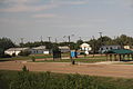
Park
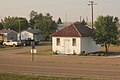
Chet Huntley School in Saco

Water Tower overlooks downtown Saco
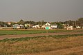
The sign for Saco looking east at U.S. Route 2


References[]
- ^ "2019 U.S. Gazetteer Files". United States Census Bureau. Retrieved July 26, 2020.
- ^ Jump up to: a b "U.S. Census website". United States Census Bureau. Retrieved 2012-12-18.
- ^ Jump up to: a b "Population and Housing Unit Estimates". United States Census Bureau. May 24, 2020. Retrieved May 27, 2020.
- ^ "US Gazetteer files: 2010, 2000, and 1990". United States Census Bureau. 2011-02-12. Retrieved 2011-04-23.
- ^ "US Gazetteer files 2010". United States Census Bureau. Archived from the original on 2012-07-02. Retrieved 2012-12-18.
- ^ Climate Summary for Saco, Montana
- ^ Jump up to: a b "Saco". Montana Place Names Companion. Montana Historical Society. Retrieved 9 April 2021.
- ^ Aarstad, Rich, Ellie Arguimbau, Ellen Baumler, Charlene Porsild, and Brian Shovers. Montana Place Names from Alzada to Zortman Archived 2009-10-08 at the Wayback Machine. Montana Historical Society Press.
- ^ "Census of Population and Housing". Census.gov. Retrieved June 4, 2015.
- ^ "Census & Economic Information Center". Retrieved July 3, 2015.
- ^ "U.S. Census website". United States Census Bureau. Retrieved 2008-01-31.
- ^ "Saco School District". Saco School District. Retrieved 13 April 2021.
- ^ "Member Schools". Montana High School Association. Retrieved 19 April 2021.
- ^ "Phillips County Library". Montana State Library. Retrieved 13 April 2021.
External links[]
| Wikimedia Commons has media related to Saco, Montana. |
| show Municipalities and communities of Phillips County, Montana, United States |
|---|

| show Authority control |
|---|
- Towns in Phillips County, Montana