Saint-Dizier
Saint-Dizier | |
|---|---|
Subprefecture and commune | |
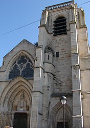 The Notre-Dame church in Saint-Dizier | |
 Coat of arms | |
show Location of Saint-Dizier | |
 Saint-Dizier | |
| Coordinates: 48°38′18″N 4°56′59″E / 48.6383°N 4.9497°ECoordinates: 48°38′18″N 4°56′59″E / 48.6383°N 4.9497°E | |
| Country | France |
| Region | Grand Est |
| Department | Haute-Marne |
| Arrondissement | Saint-Dizier |
| Canton | Saint-Dizier-1, 2 and 3 |
| Intercommunality | CA Saint-Dizier Der et Blaise |
| Government | |
| • Mayor (2020–2026) | Quentin Briere[1] |
| Area 1 | 47.69 km2 (18.41 sq mi) |
| Population (Jan. 2018)[2] | 23,382 |
| • Density | 490/km2 (1,300/sq mi) |
| Time zone | UTC+01:00 (CET) |
| • Summer (DST) | UTC+02:00 (CEST) |
| INSEE/Postal code | 52448 /52100 |
| 1 French Land Register data, which excludes lakes, ponds, glaciers > 1 km2 (0.386 sq mi or 247 acres) and river estuaries. | |


Saint-Dizier (French pronunciation: [sɛ̃.di.zje]) is a commune in the Haute-Marne department in north-eastern France.
It has a population of 23,382 (2018 figure) and is a subprefecture of the department. Although Saint-Dizier is marginally the most populous commune in Haute-Marne, the préfecture (capital) resides in the somewhat smaller commune of Chaumont.
Geography[]

Located approximately 120 miles (193 km) east of Paris, halfway to Strasbourg, it is five miles from Western Europe's largest man-made lake, Lake Der-Chantecoq.
Climate[]
| hideClimate data for Saint-Dizier (1981–2010 averages) | |||||||||||||
|---|---|---|---|---|---|---|---|---|---|---|---|---|---|
| Month | Jan | Feb | Mar | Apr | May | Jun | Jul | Aug | Sep | Oct | Nov | Dec | Year |
| Record high °C (°F) | 17.7 (63.9) |
22.6 (72.7) |
25.2 (77.4) |
29.4 (84.9) |
31.8 (89.2) |
36.8 (98.2) |
39.0 (102.2) |
40.4 (104.7) |
33.7 (92.7) |
29.2 (84.6) |
23.4 (74.1) |
18.6 (65.5) |
40.4 (104.7) |
| Average high °C (°F) | 6.1 (43.0) |
7.6 (45.7) |
11.7 (53.1) |
15.4 (59.7) |
19.7 (67.5) |
22.8 (73.0) |
25.5 (77.9) |
25.1 (77.2) |
20.8 (69.4) |
16.0 (60.8) |
10.0 (50.0) |
6.6 (43.9) |
15.7 (60.3) |
| Average low °C (°F) | 0.3 (32.5) |
0.3 (32.5) |
2.8 (37.0) |
4.9 (40.8) |
9.1 (48.4) |
12.0 (53.6) |
14.1 (57.4) |
13.7 (56.7) |
10.6 (51.1) |
7.7 (45.9) |
3.6 (38.5) |
1.3 (34.3) |
6.7 (44.1) |
| Record low °C (°F) | −19.5 (−3.1) |
−22.5 (−8.5) |
−13.6 (7.5) |
−6.0 (21.2) |
−3.0 (26.6) |
2.2 (36.0) |
3.2 (37.8) |
3.7 (38.7) |
0.2 (32.4) |
−5.1 (22.8) |
−11.7 (10.9) |
−17.3 (0.9) |
−22.5 (−8.5) |
| Average precipitation mm (inches) | 71.8 (2.83) |
60.5 (2.38) |
66.2 (2.61) |
60.2 (2.37) |
72.4 (2.85) |
65.9 (2.59) |
70.4 (2.77) |
68.8 (2.71) |
74.2 (2.92) |
78.6 (3.09) |
69.5 (2.74) |
85.2 (3.35) |
843.7 (33.22) |
| Average precipitation days | 12.2 | 10.6 | 11.8 | 10.4 | 11.0 | 10.3 | 9.6 | 9.0 | 9.6 | 11.4 | 12.2 | 13.1 | 131.1 |
| Average snowy days | 6.3 | 5.2 | 3.6 | 1.4 | 0.1 | 0.0 | 0.0 | 0.0 | 0.0 | 0.0 | 2.5 | 4.5 | 23.6 |
| Average relative humidity (%) | 86 | 81 | 78 | 73 | 74 | 75 | 74 | 77 | 81 | 85 | 87 | 86 | 79.8 |
| Mean monthly sunshine hours | 66.4 | 80.3 | 136.8 | 174.2 | 210.7 | 220.0 | 228.0 | 220.5 | 166.3 | 117.7 | 58.4 | 47.6 | 1,726.9 |
| Source 1: Météo France[3][4] | |||||||||||||
| Source 2: Infoclimat.fr (humidity and snowy days, 1961–1990)[5] | |||||||||||||
History[]
Named after an unknown saint (possibly Desiderius of Fontenelle), the town originated as a fortified settlement around a thirteenth-century château, eventually becoming a royal fortress to guard the French kingdom's eastern approaches. The town was besieged and captured by Charles V, Holy Roman Emperor, in the summer of 1544. A fire in 1775 destroyed two-thirds of the town center. The château was owned by the Orléans family until the French Revolution, was a base for German troops during World War II, and currently houses the Municipal Museum.
Population[]
|
| ||||||||||||||||||||||||||||||||||||||||||||||||||||||||||||||||||||||||||||||||||||||||||||||||||||||||||||||||||
| Source: EHESS[6] and INSEE (1968-2017)[7] | |||||||||||||||||||||||||||||||||||||||||||||||||||||||||||||||||||||||||||||||||||||||||||||||||||||||||||||||||||
Notable people[]
Saint-Dizier is the birthplace of
- Baroque-era musicologist André Pirro
- Organist André Isoir
- Conductor Jean-Paul Penin
- Former world middleweight boxing champion Marcel Thil. A street is named in his honor.
See also[]
References[]
- ^ "Répertoire national des élus: les maires". data.gouv.fr, Plateforme ouverte des données publiques françaises (in French). 2 December 2020. Retrieved 11 December 2020.
- ^ "Populations légales 2018". INSEE. 28 December 2020.
- ^ "Données climatiques de la station de Saint-Dizier" (in French). Meteo France. Retrieved January 4, 2016.
- ^ "Climat Champagne-Ardenne" (in French). Meteo France. Retrieved January 4, 2016.
- ^ "Normes et records 1961-1990: Saint-Dizier - Robinson (52) - altitude 139m" (in French). Infoclimat. Retrieved January 4, 2016.
- ^ Des villages de Cassini aux communes d'aujourd'hui: Commune data sheet Saint-Dizier, EHESS. (in French)
- ^ Population en historique depuis 1968, INSEE
External links[]
| Wikimedia Commons has media related to Saint-Dizier. |
| show Authority control |
|---|
- Communes of Haute-Marne
- Subprefectures in France
- Champagne (province)