Saint-Fabien, Quebec
Saint-Fabien | |
|---|---|
Parish municipality | |
 | |
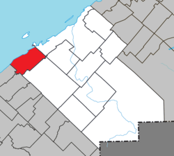 Location within Rimouski-Neigette RCM | |
 Saint-Fabien Location in eastern Quebec | |
| Coordinates: 48°18′N 68°52′W / 48.3°N 68.87°WCoordinates: 48°18′N 68°52′W / 48.3°N 68.87°W[1] | |
| Country | |
| Province | |
| Region | Bas-Saint-Laurent |
| RCM | Rimouski-Neigette |
| Constituted | July 1, 1855 |
| Government | |
| • Mayor | Marnie Perreault |
| • Federal riding | Rimouski-Neigette—Témiscouata—Les Basques |
| • Prov. riding | Rimouski |
| Area | |
| • Total | 124.10 km2 (47.92 sq mi) |
| • Land | 120.24 km2 (46.42 sq mi) |
| Population (2011)[3] | |
| • Total | 1,906 |
| • Density | 15.9/km2 (41/sq mi) |
| • Pop 2006-2011 | |
| • Dwellings | 1,199 |
| Time zone | UTC−5 (EST) |
| • Summer (DST) | UTC−4 (EDT) |
| Postal code(s) | G0L 2Z0 |
| Area code(s) | 418 and 581 |
| Highways | |
| Website | www |

Saint-Fabien is a parish municipality in the Canadian province of Quebec, located in the Rimouski-Neigette Regional County Municipality.

Baie du Ha! Ha! in Bic National Park
See also[]
References[]
- ^ Reference number 56495 of the Commission de toponymie du Québec (in French)
- ^ Jump up to: a b Geographic code 10070 in the official Répertoire des municipalités (in French)
- ^ Jump up to: a b "(Code 2410070) Census Profile". 2011 census. Statistics Canada. 2012.
External links[]
 Media related to Saint-Fabien, Quebec at Wikimedia Commons
| show Adjacent Municipal Subdivisions |
|---|
| hide | |
|---|---|
| Cities & Towns | |
| Municipalities | |
| Parishes | |
| Unorganized territories | |
| |
| show Authority control |
|---|
This Bas-Saint-Laurent location article is a stub. You can help Wikipedia by . |
Categories:
- Parish municipalities in Quebec
- Incorporated places in Bas-Saint-Laurent
- Bas-Saint-Laurent geography stubs