Saint-Hilarion, Quebec
show This article may be expanded with text translated from the corresponding article in French. (May 2010) Click [show] for important translation instructions. |
Saint-Hilarion | |
|---|---|
Parish municipality | |
 | |
 Location within Charlevoix RCM. | |
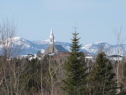
 Saint-Hilarion Location in central Quebec. | |
| Coordinates: 47°34′N 70°24′W / 47.567°N 70.400°WCoordinates: 47°34′N 70°24′W / 47.567°N 70.400°W[1] | |
| Country | |
| Province | |
| Region | Capitale-Nationale |
| RCM | Charlevoix |
| Constituted | July 1, 1855 |
| Government | |
| • Mayor | Rosaire Lavoie |
| • Federal riding | Montmorency—Charlevoix —Haute-Côte-Nord |
| • Prov. riding | Charlevoix–Côte-de-Beaupré |
| Area | |
| • Total | 101.00 km2 (39.00 sq mi) |
| • Land | 99.65 km2 (38.48 sq mi) |
| Population | |
| • Total | 1,181 |
| • Density | 11.9/km2 (31/sq mi) |
| • Pop 2006-2011 | |
| • Dwellings | 572 |
| Time zone | UTC−5 (EST) |
| • Summer (DST) | UTC−4 (EDT) |
| Postal code(s) | G0A 3V0 |
| Area code(s) | 418 and 581 |
| Highways | |
| Website | www |

Saint-Hilarion is a parish municipality in the Capitale-Nationale region of the province of Quebec in Canada.
Demographics[]
Population trend:[4]
- Population in 2011: 1181 (2006 to 2011 population change: -0.8%)
- Population in 2006: 1191
- Population in 2001: 1148
- Population in 1996: 1215
- Population in 1991: 1185
Private dwellings occupied by usual residents: 466 (total dwellings: 572)
Mother tongue:
- English as first language: 0%
- French as first language: 100%
- English and French as first language: 0%
- Other as first language: 0%
References[]
- ^ Reference number 56727 of the Commission de toponymie du Québec (in French)
- ^ Jump up to: a b Ministère des Affaires municipales, des Régions et de l'Occupation du territoire - Répertoire des municipalités: Saint-Hilarion
- ^ Jump up to: a b "Saint-Hilarion census profile". Statistics Canada, 2011 Census of Population. 2007-03-13. Retrieved 2007-07-20.
- ^ Statistics Canada: 1996, 2001, 2006, 2011 census
See also[]
- Charlevoix Regional County Municipality
- Jean-Noël River
- Rivière du Premier Rang
- Rivière à la Loutre (Gouffre River tributary)
- Rivière de Chicago
- Saint Lawrence River
- List of municipalities in Quebec
| show Places adjacent to Saint-Hilarion, Quebec |
|---|
| hide | |
|---|---|
| Cities & towns | |
| Municipalities | |
| Parishes | |
| Unorganized territories | |
| |
| show Authority control |
|---|
Categories:
- Parish municipalities in Quebec
- Incorporated places in Capitale-Nationale