Saint-Marcel-Campes
Saint-Marcel-Campes | |
|---|---|
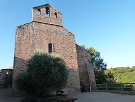 The church of Saint-Michel, in Saint-Marcel-Campes | |
show Location of Saint-Marcel-Campes | |
 Saint-Marcel-Campes | |
| Coordinates: 44°04′52″N 1°59′25″E / 44.0811°N 1.9903°ECoordinates: 44°04′52″N 1°59′25″E / 44.0811°N 1.9903°E | |
| Country | France |
| Region | Occitanie |
| Department | Tarn |
| Arrondissement | Albi |
| Canton | Carmaux-2 Vallée du Cérou |
| Intercommunality | CC du Cordais et du Causse |
| Government | |
| • Mayor (2020–2026) | Alex Brière[1] |
| Area 1 | 22.34 km2 (8.63 sq mi) |
| Population (Jan. 2018)[2] | 212 |
| • Density | 9.5/km2 (25/sq mi) |
| Time zone | UTC+01:00 (CET) |
| • Summer (DST) | UTC+02:00 (CEST) |
| INSEE/Postal code | 81262 /81170 |
| Elevation | 158–448 m (518–1,470 ft) (avg. 400 m or 1,300 ft) |
| 1 French Land Register data, which excludes lakes, ponds, glaciers > 1 km2 (0.386 sq mi or 247 acres) and river estuaries. | |


Saint-Marcel-Campes is a commune in the Tarn department in southern France.
Geography[]
The commune is traversed by the Cérou river.
See also[]
- Communes of the Tarn department
References[]
- ^ "Répertoire national des élus: les maires". data.gouv.fr, Plateforme ouverte des données publiques françaises (in French). 2 December 2020.
- ^ "Populations légales 2018". INSEE. 28 December 2020.
| Wikimedia Commons has media related to Saint-Marcel-Campes. |
| show Authority control |
|---|
This Tarn geographical article is a stub. You can help Wikipedia by . |
Categories:
- Communes of Tarn (department)
- Tarn (department) geography stubs