Saint-René, Quebec
Saint-René | |
|---|---|
Parish municipality | |
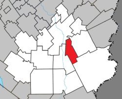 Location within Beauce-Sartigan RCM. | |
 Saint-René Location in southern Quebec. | |
| Coordinates: 46°01′N 70°37′W / 46.017°N 70.617°WCoordinates: 46°01′N 70°37′W / 46.017°N 70.617°W[1] | |
| Country | |
| Province | |
| Region | Chaudière-Appalaches |
| RCM | Beauce-Sartigan |
| Constituted | January 1, 1945 |
| Named for | René Goupil[1] |
| Government | |
| • Mayor | Jean-Guy Deblois |
| • Federal riding | Beauce |
| • Prov. riding | Beauce-Sud |
| Area | |
| • Total | 61.40 km2 (23.71 sq mi) |
| • Land | 63.35 km2 (24.46 sq mi) |
| There is an apparent contradiction between two authoritative sources | |
| Population (2011)[3] | |
| • Total | 658 |
| • Density | 10.4/km2 (27/sq mi) |
| • Pop 2006-2011 | |
| • Dwellings | 285 |
| Time zone | UTC−5 (EST) |
| • Summer (DST) | UTC−4 (EDT) |
| Postal code(s) | G0M 1Z0 |
| Area code(s) | 418 and 581 |
| Highways | No major routes |

Saint-René is a parish in the Beauce-Sartigan Regional County Municipality in Quebec, Canada. It is part of the Chaudière-Appalaches region and the population is 603 as of 2009. It is named after Canadian martyr René Goupil.[1]
References[]
- Commission de toponymie du Québec
- Ministère des Affaires municipales, des Régions et de l'Occupation du territoire
| show Places adjacent to Saint-René, Quebec |
|---|
| show |
|---|
Categories:
- Incorporated places in Chaudière-Appalaches
- Parish municipalities in Quebec