Saint-René-de-Matane, Quebec
Saint-René-de-Matane | |
|---|---|
Municipality | |
 Jean-Chassé covered bridge | |
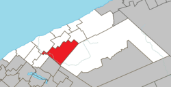 Location within La Matanie RCM. | |
 Saint-René-de-Matane Location in eastern Quebec. | |
| Coordinates: 48°42′N 67°23′W / 48.700°N 67.383°WCoordinates: 48°42′N 67°23′W / 48.700°N 67.383°W[1] | |
| Country | |
| Province | |
| Region | Bas-Saint-Laurent |
| RCM | La Matanie |
| Constituted | December 18, 1982 |
| Government | |
| • Mayor | Roger Vaillancourt |
| • Federal riding | Haute-Gaspésie—La Mitis—Matane—Matapédia |
| • Prov. riding | Matane-Matapédia |
| Area | |
| • Total | 256.20 km2 (98.92 sq mi) |
| • Land | 255.39 km2 (98.61 sq mi) |
| Population | |
| • Total | 1,089 |
| • Density | 4.3/km2 (11/sq mi) |
| • Pop 2006-2011 | |
| • Dwellings | 639 |
| Time zone | UTC−5 (EST) |
| • Summer (DST) | UTC−4 (EDT) |
| Postal code(s) | G0J 3E0 |
| Area code(s) | 418 and 581 |
| Highways | |
| Website | www.municipalite. st-rene-matane.qc.ca |

Saint-René-de-Matane is a municipality in Quebec, Canada.
In addition to main population centre of Saint-René located along Quebec Route 195, the municipality also includes the communities of Le Renversé, Rivière-Matane, Ruisseau-Gagnon, and Village-à-Dancause.
Demographics[]
Population[]
| hideCanada census – Saint-René-de-Matane, Quebec community profile | |||
|---|---|---|---|
| 2011 | 2006 | ||
| Population: | 1,089 (+1.8% from 2006) | 1,070 (+10.5% from 2001) | |
| Land area: | 255.39 km2 (98.61 sq mi) | 255.39 km2 (98.61 sq mi) | |
| Population density: | 4.3/km2 (11/sq mi) | 4.2/km2 (11/sq mi) | |
| Median age: | 48.1 (M: 48.6, F: 46.9) | 44.8 (M: 45.4, F: 44.4) | |
| Total private dwellings: | 639 | 619 | |
| Median household income: | $.N/A | $31,294 | |
| Notes: 2011 income data for this area has been suppressed for data quality or confidentiality reasons. 2006 Community Profile includes adjusted figures due to boundary change. – References: 2011[3] 2006[4] earlier[5] | |||
|
|
|
|
|

Matane River at Saint-René-de-Matane
See also[]
References[]
- ^ Reference number 137702 of the Commission de toponymie du Québec (in French)
- ^ Jump up to: a b "Saint-René-de-Matane". Répertoire des municipalités (in French). Ministère des Affaires municipales, des Régions et de l'Occupation du territoire. Retrieved 2012-01-23.
- ^ Jump up to: a b c "2011 Community Profiles". 2011 Canadian Census. Statistics Canada. July 5, 2013. Retrieved 2013-05-19.
- ^ "2006 Community Profiles". 2006 Canadian Census. Statistics Canada. March 30, 2011. Retrieved 2012-01-23.
- ^ "2001 Community Profiles". 2001 Canadian Census. Statistics Canada. February 17, 2012.
- ^ Statistics Canada: 1996, 2001, 2006, 2011 census
| Wikimedia Commons has media related to Saint-René-de-Matane. |
| show Adjacent Municipal Subdivisions |
|---|
| hide | |
|---|---|
| Cities & Towns | |
| Municipalities | |
| Parishes | |
| Unorganized territories | |
| |
| Authority control |
|
|---|
Categories:
- Incorporated places in Bas-Saint-Laurent
- Municipalities in Quebec