Saint-Robert-Bellarmin, Quebec
Saint-Robert-Bellarmin | |
|---|---|
Municipality | |
 | |
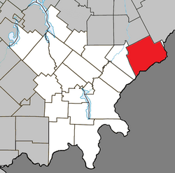 Location within Le Granit RCM | |
 Saint-Robert-Bellarmin Location in southern Quebec | |
| Coordinates: 45°45′N 70°35′W / 45.75°N 70.58°WCoordinates: 45°45′N 70°35′W / 45.75°N 70.58°W[1] | |
| Country | |
| Province | |
| Region | Estrie |
| RCM | Le Granit |
| Constituted | January 1, 1949 |
| Government | |
| • Mayor | Jeannot Lachance |
| • Federal riding | Beauce |
| • Prov. riding | Beauce-Sud |
| Area | |
| • Total | 237.80 km2 (91.82 sq mi) |
| • Land | 237.26 km2 (91.61 sq mi) |
| Population (2011)[3] | |
| • Total | 676 |
| • Density | 2.8/km2 (7/sq mi) |
| • Pop 2006-2011 | |
| • Dwellings | 253 |
| Time zone | UTC−5 (EST) |
| • Summer (DST) | UTC−4 (EDT) |
| Postal code(s) | G0M 2E0 |
| Area code(s) | 418 and 581 |
| Highways | No major routes |
| Website | www |

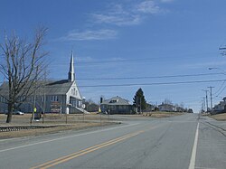
Saint-Robert-Bellarmin is a municipality in the Municipalité régionale de comté du Granit in Estrie, Quebec, Canada, located on the Canada–United States border. Population is 645 as of 2006.
It is also the location of the Saint-Robert-Bellarmin Wind Project, an 80 MW project located 3 km East-South-East of the town.
The area had already been settled in 1907. The local economy revolves mostly around lumber, sugar bushes and the seasonal deer hunt. Many Bellarminois work in neighbouring Saint-Gédéon-de-Beauce.
The municipality was named after Robert Bellarmine, an Italian Jesuit who participated actively in the Counter-Reformation.
References[]
- ^ Reference number 57579 of the Commission de toponymie du Québec (in French)
- ^ Jump up to: a b Geographic code 30070 in the official Répertoire des municipalités (in French)
- ^ Jump up to: a b "(Code 2430070) Census Profile". 2011 census. Statistics Canada. 2012.
External links[]
 Media related to Saint-Robert-Bellarmin at Wikimedia Commons
- Commission de toponymie du Québec
- Ministère des Affaires municipales, des Régions et de l'Occupation du territoire
| show Places adjacent to Saint-Robert-Bellarmin, Quebec |
|---|
| show |
|---|
Categories:
- Municipalities in Quebec
- Incorporated places in Estrie
- Le Granit Regional County Municipality