Saint-Sulpice-la-Pointe
Saint-Sulpice-la-Pointe | |
|---|---|
 An aerial view of Saint-Sulpice | |
 Coat of arms | |
show Location of Saint-Sulpice-la-Pointe | |
 Saint-Sulpice-la-Pointe | |
| Coordinates: 43°46′30″N 1°41′14″E / 43.775°N 1.6872°ECoordinates: 43°46′30″N 1°41′14″E / 43.775°N 1.6872°E | |
| Country | France |
| Region | Occitanie |
| Department | Tarn |
| Arrondissement | Castres |
| Canton | Les Portes du Tarn |
| Intercommunality | Tarn-Agout |
| Government | |
| • Mayor (2020–2026) | Raphaël Bernardin |
| Area 1 | 23.99 km2 (9.26 sq mi) |
| Population (Jan. 2018)[1] | 9,227 |
| • Density | 380/km2 (1,000/sq mi) |
| Time zone | UTC+01:00 (CET) |
| • Summer (DST) | UTC+02:00 (CEST) |
| INSEE/Postal code | 81271 /81370 |
| Elevation | 95–195 m (312–640 ft) (avg. 112 m or 367 ft) |
| 1 French Land Register data, which excludes lakes, ponds, glaciers > 1 km2 (0.386 sq mi or 247 acres) and river estuaries. | |


Saint-Sulpice-la-Pointe (French pronunciation: [sɛ̃ sylpis la pwɛ̃t], before 2013: Saint-Sulpice; Languedocien: Sant Somplesi)[2] is a commune in the Tarn department in southern France. During World War 2 a concentration camp was built in this town.
Transport[]
- Gare de Saint-Sulpice-sur-Tarn
Remarkable places and monuments[]

Town hall
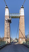
The suspension bridge over the Agout.

War memorial.
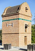
Dovecote from 1810
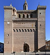
Church Notre-Dame

View of the nave


See also[]
- Communes of the Tarn department
References[]
- ^ "Populations légales 2018". INSEE. 28 December 2020.
- ^ Décret n° 2013-986 5 November 2013 (in French)
| Wikimedia Commons has media related to Saint-Sulpice-la-Pointe. |
| show Authority control |
|---|
This Tarn geographical article is a stub. You can help Wikipedia by . |
Categories:
- Communes of Tarn (department)
- Tarn (department) geography stubs