Sainte-Marguerite, Chaudière-Appalaches, Quebec
show This article may be expanded with text translated from the corresponding article in French. (February 2019) Click [show] for important translation instructions. |
Sainte-Marguerite | |
|---|---|
Parish municipality | |
 Church and municipal building. | |
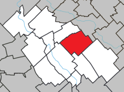
 Location within La Nouvelle-Beauce RCM. | |
 Sainte-Marguerite Location in southern Quebec. | |
| Coordinates: 46°31′N 70°56′W / 46.517°N 70.933°WCoordinates: 46°31′N 70°56′W / 46.517°N 70.933°W[1] | |
| Country | |
| Province | |
| Region | Chaudière-Appalaches |
| RCM | La Nouvelle-Beauce |
| Constituted | July 1, 1855 |
| Government | |
| • Mayor | Claude Perreault |
| • Federal riding | Beauce |
| • Prov. riding | Beauce-Nord |
| Area | |
| • Total | 83.10 km2 (32.09 sq mi) |
| • Land | 83.30 km2 (32.16 sq mi) |
| There is an apparent contradiction between two authoritative sources | |
| Population (2019)[3] | |
| • Total | 1,107 |
| • Density | 12.9/km2 (33/sq mi) |
| • Pop 2006-2011 | |
| • Dwellings | 495 |
| Time zone | UTC−5 (EST) |
| • Summer (DST) | UTC−4 (EDT) |
| Postal code(s) | G0S 2X0 |
| Area code(s) | 418 and 581 |
| Highways | |
Sainte-Marguerite is a parish municipality in La Nouvelle-Beauce Regional County Municipality in the Chaudière-Appalaches region of Quebec, Canada. Its population is 1,107 as of the Canada 2011 Census. It is named after Marguerite Marcoux, who gave part of the land she owned in 1830 for the construction of a church.
References[]
- ^ Reference number 56278 of the Commission de toponymie du Québec (in French)
- ^ Jump up to: a b Geographic code 26035 in the official Répertoire des municipalités (in French)
- ^ Jump up to: a b "(Code 2426035) Census Profile". 2011 census. Statistics Canada. 2012.
- Commission de toponymie du Québec
- Ministère des Affaires municipales, des Régions et de l'Occupation du territoire
Categories:
- Parish municipalities in Quebec
- Incorporated places in Chaudière-Appalaches
