San Basilio, Sardinia
San Basilio
Santu 'Asili 'e Monti | |
|---|---|
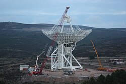 The Sardinia Radio Telescope (SRT) under construction | |
Location of San Basilio  | |
 San Basilio Location of San Basilio in Sardinia | |
| Coordinates: 39°32′N 9°12′E / 39.533°N 9.200°ECoordinates: 39°32′N 9°12′E / 39.533°N 9.200°E | |
| Country | Italy |
| Region | Sardinia |
| Province | South Sardinia |
| Area | |
| • Total | 44.9 km2 (17.3 sq mi) |
| Population (December 2004)[1] | |
| • Total | 1,371 |
| • Density | 31/km2 (79/sq mi) |
| Time zone | UTC+1 (CET) |
| • Summer (DST) | UTC+2 (CEST) |
| Postal code | 09040 |
| Dialing code | 070 |


San Basilio, Santu 'Asili 'e Monti in sardinian language, is a comune (municipality) in the Province of South Sardinia in the Italian region Sardinia, about 35 km (22 mi) north of Cagliari. As of 31 December 2004, it has a population of 1,371 and an area of 44.9 km2 (17.3 sq mi).[2]
San Basilio borders the municipalities of San Nicolò Gerrei, Sant'Andrea Frius, Senorbì, Silius, and Siurgus Donigala.
Demographic evolution[]

References[]
| Wikimedia Commons has media related to San Basilio (comune, Italy). |
- ^ "Popolazione Residente al 1° Gennaio 2018". Italian National Institute of Statistics. Retrieved 16 March 2019.
- ^ All demographics and other statistics: Italian statistical institute Istat.
See also[]
This Sardinia location article is a stub. You can help Wikipedia by . |
Categories:
- Cities and towns in Sardinia
- Municipalities of the Province of South Sardinia
- Sardinia geography stubs