San Fernando Pastoral Region
The San Fernando Pastoral Region is a pastoral region of the Archdiocese of Los Angeles in the Roman Catholic Church. It covers the San Fernando, Santa Clarita, and Antelope Valleys. The current regional auxiliary bishop is Bishop Alejandro D. Aclan. The Region has 54 parishes, 12 high schools, 2 hospitals, and 1 Spanish Mission.
Parishes[]
Deanery 5 (West San Fernando Valley)[]


Deanery 6 (Crescenta Valley, Glendale and Northeast Los Angeles)[]


Deanery 7 (Central San Fernando Valley and Burbank)[]


Deanery 8 (Santa Clarita Valley and Lancaster/Palmdale)[]
| Church name | Image | Address | Community | School |
|---|---|---|---|---|
| Blessed Junipero Serra | 6122 West Azalea Drive 34°38′59″N 118°14′21″W / 34.64972°N 118.23917°W |
Lancaster | No | |
| Blessed Kateri Tekakwitha | 22508 Copper Hill Drive 34°27′36″N 118°31′52″W / 34.46000°N 118.53111°W |
Santa Clarita (Valencia) | No | |
| Our Lady of Perpetual Help | 23233 West Lyons Avenue 34°22′48″N 118°32′22″W / 34.38000°N 118.53944°W |
Santa Clarita (Newhall) | K-8 [43] | |
| Sacred Heart | 45007 North Cedar Avenue 34°42′00″N 118°08′24″W / 34.70000°N 118.14000°W |
Lancaster | K-8 [44] | |
| St. Clare | 19606 Calla Way 34°25′11″N 118°28′41″W / 34.41972°N 118.47806°W |
Santa Clarita (Canyon Country) | No | |
| St. Mary | 1600 East Avenue R4 34°34′07″N 118°06′04″W / 34.56861°N 118.10111°W |
Palmdale | K-8 [45] |
Spanish Missions[]
| Church name | Image | Address | Community |
|---|---|---|---|
| San Fernando Rey Mission | 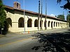
|
15151 San Fernando Mission Blvd. 34°16′23″N 118°27′40″W / 34.27306°N 118.46111°W |
Mission Hills |
Monasteries or Convents[]
| Church name | Image | Address | Community |
|---|---|---|---|
| St. Andrew's Abbey | 31001 N. Valyermo Rd. 34°26′36″N 117°51′05″W / 34.44333°N 117.85139°W |
Valyermo | |
| Holy Spirit Retreat Center | 4316 Lanai Rd. 34°08′53″N 118°29′24″W / 34.14806°N 118.49000°W |
Encino |
Universities or Colleges[]
There are no Catholic universities or colleges in this Pastoral Region.
High schools[]
| School name | Image | Address | Community |
|---|---|---|---|
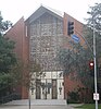
| Bellarmine-Jefferson High School | 
|
465 East Olive Ave. | Burbank |
| Bishop Alemany High School | 
|
11111 North Alemany Drive | Mission Hills |
| Chaminade High School | 7500 Chaminade Ave. | West Hills | |
| Crespi Carmelite High School | 5031 Alonzo Ave. | Encino | |
| Flintridge-Sacred Heart Academy | 440 Saint Katherine Drive | La Cañada Flintridge | |
| Holy Family High School | 400 East Lomita Ave. | Glendale | |
| Louisville High School | 22300 Mulholland Dr. | Woodland Hills | |
| Notre Dame High School | 
|
13645 Riverside Drive | Sherman Oaks |
| Paraclete High School | 42145 30th St. West | Lancaster | |
| Providence High School (Burbank, California) | 
|
511 South Buena Vista Street | Burbank |
| St. Francis High School | 200 Foothill Boulevard | La Cañada Flintridge | |
| St. Genevieve High School | 
|
13967 Roscoe Blvd. | Panorama City |
Elementary schools[]
Parish-affiliated elementary schools are noted above in the charts listing parishes. In addition to parish-affiliated elementary schools, there is one non-affiliated middle school in the San Fernando Pastoral Region.
- Chaminade Middle School, Chatsworth (Grades 6-8)
Hospitals[]
| Hospital | Image | Address | Community |
|---|---|---|---|
| Northridge Hospital Medical Center | 18300 Roscoe Blvd. 34°13′12″N 118°31′58″W / 34.22000°N 118.53278°W |
Northridge | |
| Providence Holy Cross Medical Center | 15031 Rinaldi St. 34°16′48″N 118°27′36″W / 34.28000°N 118.46000°W |
Mission Hills |
Cemeteries[]
| Cemetery | Image | Address | Community |
|---|---|---|---|
| San Fernando Mission Cemetery | 11160 Stranwood Ave. 34°16′29″N 118°27′53″W / 34.27472°N 118.46472°W |
San Fernando |
See also[]
- Roman Catholic Archdiocese of Los Angeles
- List of schools in the Roman Catholic Archdiocese of Los Angeles
External links[]
Categories:
- Roman Catholic Archdiocese of Los Angeles
- San Fernando Valley
- Lists of churches in the United States by diocese