Sangareddy district
Sangareddy district | |
|---|---|
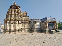 Ramalingeshwara temple, Nandikandi | |
 Location of Sangareddy district in Telangana | |
| Coordinates (Sangareddy): 17.780532, 77.892057 | |
| Country | |
| State | Telangana |
| Mandals | 26 |
| Created | 11 October 2016[1] |
| Founded by | Government of Telangana, |
| Headquarters | Sangareddy |
| Revenue Divisions | 04 |
| Government | |
| • Type | Zilla Panchayath |
| • Body | Sangareddy Zilla Panchayath |
| • Collector | M. Hanumantha Rao, IAS |
| Area | |
| • Total | 4,996.46 km2 (1,929.14 sq mi) |
| Population (2011) | |
| • Total | 1,495,503 |
| • Density | 372/km2 (960/sq mi) |
| Time zone | UTC+05:30 (IST) |
| Vehicle registration | TS 15 |
| Major highways | |
| Website | sangareddy |
Sangareddy district, is a district in the Indian state of Telangana. This district contains a part of the Hyderabad Metropolitan Region.[2] The district shares boundaries with Medak, Medchal, Vikarabad, Kamareddy and Rangareddy districts and with the state boundary of Karnataka.
Geography[]
The district is spread over an area of 4,464.87 square kilometres (1,723.90 sq mi).[3]
Demographics[]
As of 2011 Census of India, the district has a population of 1,495,503. Scheduled Castes and Scheduled Tribes are 17.96% and 5.70% of the population respectively.[4]
Hindus are 81.44% while Muslims are 16.15% and Christians are 1.56% of the population.[5]
At the time of the 2011 census, 70.97% of the population spoke Telugu, 15.63% Urdu, 5.03% Lambadi, 3.84% Kannada, 1.76% Hindi and 1.32% Marathi as their first language.[6]
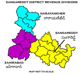
Administrative divisions[]
The district has four revenue divisions of Narayankhed, Sangareddy, Zaheerabad, Andole–Jogipet which are sub-divided into 27 mandals.[2] M. Hanumantha Rao is the present collector of the district.[7]
Mandals[]
| S.No. | Narayankhed revenue division | Sangareddy revenue division | Zaheerabad revenue division |
|---|---|---|---|
| 1 | Kalher | Ameenpur | Jharasangam |
| 2 | Kangti | Andole | Kohir |
| 3 | Manoor | Gummadidala | Mogudampally |
| 4 | Nagilgidda | Hathnoora | Nyalkal |
| 5 | Narayankhed | Jinnaram | Raikode |
| 6 | Sirgapoor | Kandi | Zahirabad |
| 7 | Kondapur | ||
| 8 | Munipally | ||
| 9 | Patancheru | ||
| 10 | Pulkal | ||
| 11 | Ramachandrapuram | ||
| 12 | Sadasivpet | ||
| 13 | Sangareddy | ||
| 14 | Vatpally |
See also[]
- List of districts in Telangana
References[]
- ^ https://sangareddy.telangana.gov.in/
- ^ Jump up to: a b "Sangareddy district" (PDF). New Districts Formation Portal. Retrieved 11 October 2016.
- ^ "New districts". Andhra Jyothy.com. 8 October 2016. Retrieved 8 October 2016.
- ^ District census 2011: Medak Table 13: population by Mandal
- ^ "C-16 Population By Religion - Andhra Pradesh". census.gov.in.
- ^ 2011 Census of India, Population By Mother Tongue
- ^ "K Chandrasekhar Rao appoints collectors for new districts". Deccan Chronicle. 11 October 2016. Retrieved 13 October 2016.
External links[]
| show Places adjacent to Sangareddy district |
|---|
| hide | |
|---|---|
| Topics | |
| Dynasties | |
| Districts |
|
| Commissionerates | |
| Major cities | |
| Tourism |
|
| Municipal corporations | |
| Related lists | |
- Sangareddy district
- Districts of Telangana
- 2016 establishments in Telangana