Nalgonda district
Nalgonda district | |
|---|---|
 | |
 Location of Nalgonda district in Telangana | |
| Country | India |
| State | Telangana |
| Division | Nalgonda, Miryalaguda, Devarakonda |
| Headquarters | Nalgonda |
| Tehsils | 31 |
| Government | |
| • District collector | Gaurav Uppal |
| • Lok Sabha constituencies | N Uttam Kumar Reddy |
| • Vidhan Sabha constituencies | 6 assembly seats |
| Area | |
| • Total | 7,122 km2 (2,750 sq mi) |
| Population (2011) | |
| • Total | 1,618,416 |
| • Density | 230/km2 (590/sq mi) |
| Demographics | |
| • Literacy | 65.05 |
| Time zone | UTC+05:30 (IST) |
| Vehicle registration | TS – 05[1] |
| Major highways | NH-65, NH-561, SH-2 |
| Average annual precipitation | Normal rainfall 751.0 mm; average rainfall 670.2 mm |
| Website | www |
Nalgonda district is a district in the Telangana state of India. Nalgonda district has the highest number of mandals in the state with 31 mandals.[2] The district shares boundaries with Suryapet, Rangareddy, Yadadri and Nagarkurnool districts and with the state boundary of Andhra Pradesh.
Etymology[]
Nalgonda is derived from two Telugu words Nalla (Black) & Konda (Hills) i.e. Black Hills.[3]
History[]

Nalgonda was earlier referred to as Neelagiri, the name given by some local rulers and the name was changed to Nallagonda only after its conquest by Allauddin Bahaman Shah, the founder of Bahmani Sultanate .


The district had a major role in the Telangana Rebellion.
Geography[]
The district is spread over an area of 7,122 square kilometres (2,750 sq mi).[4]
Demographics[]
As of 2011 Census of India, the district has a population of 1,618,416. According to the 2011 census, 81.75% of the population spoke Telugu, 11.91% Lambadi and 5.51% Urdu as their first language.[4]
The Krishna River, Musi River, Aleru, Peddavagu, Dindi River, Halia River and Paleru flow through the Nalgonda district.[citation needed]
Economy[]

In 2006 the Indian government named Nalgonda one of the country's 250 poorest districts (out of a total of 640).[5] It is one of the nine districts in Telangana currently receiving funds from the Backward Regions Grant Fund Programme (BRGF).[5]
Major Cities[]
Major Towns[]
Notable places in District[]
- Latif Saheb Hill in Nalgonda
- Sri Chaya Someshwara Temple - 5 km (3.1 mi) from Nalgonda
- Udaya Samudram -6 km (3.7 mi) from Nalgonda
- Devarkonda Fort - 60 km (37 mi) from Nalgonda
- Nagarjuna sagar Dam - 64 km (40 mi) from Nalgonda
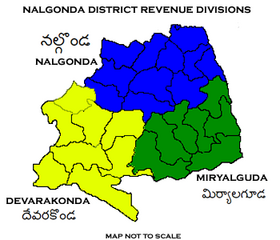
Administrative divisions[]
The district is divided into three revenue divisions: Nalgonda, Miryalaguda, and Devarakonda. These are sub-divided into 31 mandals and has 565 villages.[4] Prashanth Jeevan Patil is the present collector of the district.[6]
Mandals[]
The below table categorizes the mandals into their respective revenue divisions in the district:
| # | Nalgonda Division | Miryalaguda Division | Devarakonda Division |
|---|---|---|---|
| 1 | Chandur | Dameracherla | Chandampet |
| 2 | Chityal | Miryalaguda | Chintapally |
| 3 | Kanagal | Vemulapally | Devarakonda |
| 4 | Kattangur | Gundlapally | |
| 5 | Gurrampode | Nidamanur | |
| 6 | Munugode | Peddavoora | |
| 7 | Nakrekal | Tripuraram | Nampally |
| 8 | Nalgonda | Marriguda | |
| 9 | Narayanapur | Thirumalagiri (Sagar) | Pedda Adiserla Pally |
| 10 | Narketpally | ||
| 11 | Shaligowraram | Ashok Nagar | |
| 12 | Thipparthy | ||
| 13 |

See also[]
- Chinna Kaparthy
- Dandampally
- List of districts in Telangana
References[]
- ^ "Vehicle Registration Codes for New Districts in Telangana".
- ^ "Census GIS India". Censusindiamaps.net. Archived from the original on 3 July 2007. Retrieved 13 June 2012.
- ^ "Nalgonda travel guide". World66.com. Retrieved 13 June 2012.
- ^ Jump up to: a b c "New districts". Andhra Jyothy.com. 8 October 2016. Retrieved 8 October 2016.
- ^ Jump up to: a b Ministry of Panchayati Raj (8 September 2009). "A Note on the Backward Regions Grant Fund Programme" (PDF). National Institute of Rural Development. Archived from the original (PDF) on 5 April 2012. Retrieved 27 September 2011.
- ^ "Who's who". 26 February 2020. Retrieved 26 February 2020.
External links[]
| Wikimedia Commons has media related to Nalgonda district. |
| Wikivoyage has a travel guide for Nalgonda (district). |
| show Places adjacent to Nalgonda district |
|---|
| show Authority control |
|---|
- Nalgonda district
- Districts of Telangana