Satoshō
Satoshō
里庄町 | |||||||||
|---|---|---|---|---|---|---|---|---|---|
Town | |||||||||
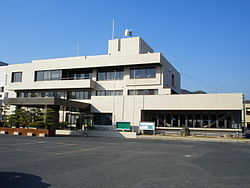
 Satoshō town office | |||||||||
 Flag  Chapter | |||||||||
 Location of Satoshō in Okayama Prefecture | |||||||||
 Satoshō Location in Japan | |||||||||
| Coordinates: 34°31′N 133°33′E / 34.517°N 133.550°ECoordinates: 34°31′N 133°33′E / 34.517°N 133.550°E | |||||||||
| Country | Japan | ||||||||
| Region | Chūgoku San'yō | ||||||||
| Prefecture | Okayama Prefecture | ||||||||
| District | Asakuchi | ||||||||
| Area | |||||||||
| • Total | 12.23 km2 (4.72 sq mi) | ||||||||
| Population (March 31, 2017) | |||||||||
| • Total | 11,204 | ||||||||
| • Density | 920/km2 (2,400/sq mi) | ||||||||
| Time zone | UTC+09:00 (JST) | ||||||||
| Website | www | ||||||||
| |||||||||
Satoshō (里庄町, Satoshō-chō) is a town located in Asakuchi District, Okayama Prefecture, Japan.
As of March 2017, the town has an estimated population of 11,204 and a density of 920 persons per km².[1] The total area is 12.23 km².
Industries include food processing factories (Amano Foods), electronics (Sharp), medicines (Fusso) etc.
Geography[]
Neighbouring municipalities[]
In 2005, it declined to amalgamate with the neighboring towns of Kamogata and Yorishima to form the city of Asakuchi.
Transportation[]
Raliway[]
- JR West
Notable people[]
- Yoshio Nishina, former physicist
- Gōtarō Ogawa, former economist, educator, politician and cabinet minister
References[]
- ^ "Official website of Satoshō city" (in Japanese). Japan: Satoshō City. Retrieved 15 April 2017.
External links[]
 Media related to Satoshō, Okayama at Wikimedia Commons
- Satoshō official website (in Japanese)
Categories:
- Towns in Okayama Prefecture
- Okayama geography stubs
