Schalls, Missouri
Schalls, Missouri. | |
|---|---|
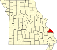 Location of Perry County, Missouri | |
| Coordinates: 37°40′01″N 89°41′11″W / 37.66694°N 89.68639°WCoordinates: 37°40′01″N 89°41′11″W / 37.66694°N 89.68639°W | |
| Country | United States |
| State | Missouri |
| County | Perry |
| Township | Union |
| Elevation | 620 ft (189[1] m) |
| Time zone | UTC-6 (Central (CST)) |
| • Summer (DST) | UTC-5 (CDT) |
| ZIP code | 63775 |
| Area code(s) | 573 |
| GNIS feature ID | 726093[2] |

Schalls is an unincorporated community in Union Township in Perry County, Missouri, United States.[3] Schalls is situated in the north-central corner of Perry County. A post office was maintained from 1886 through 1910. The community was named after Maritz Schall, a pioneer stock dealer and farmer.[3][4][5]
References[]
- ^ Cartographic.usa http://cartographic.info/usa/map.php?id=726093
- ^ National Explorer http://nationexplorer.com/feature/726093
- ^ a b State Historical Society of Missouri: Perry County http://shs.umsystem.edu/manuscripts/ramsay/ramsay_perry.html
- ^ A Directory of Towns, Villages, and Hamlets Past and Present of Perry County, Missouri "Archived copy". Archived from the original on 2013-11-03. Retrieved 2013-11-26.
{{cite web}}: CS1 maint: archived copy as title (link) - ^ Eaton, David Wolfe (1917). How Missouri Counties, Towns and Streams Were Named. The State Historical Society of Missouri. pp. 338.
Municipalities and communities of Perry County, Missouri, United States | ||
|---|---|---|
| Cities |  | |
| Village | ||
| Townships | ||
| CDPs | ||
| Other communities | ||
| Abandoned villages | ||
| Footnotes | ‡This populated place also has portions in an adjacent county or counties | |
| ||
This Perry County, Missouri state location article is a stub. You can help Wikipedia by . |
Categories:
- Unincorporated communities in Perry County, Missouri
- Unincorporated communities in Missouri
- Southeast Missouri geography stubs