Scott Township, Montgomery County, Indiana
Scott Township | |
|---|---|
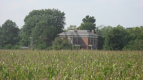 Ashby, a historic home in the township | |
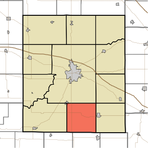 Location in Montgomery County | |
| Coordinates: 39°54′40″N 86°52′13″W / 39.91111°N 86.87028°WCoordinates: 39°54′40″N 86°52′13″W / 39.91111°N 86.87028°W | |
| Country | |
| State | |
| County | Montgomery |
| Government | |
| • Type | Indiana township |
| Area | |
| • Total | 35.88 sq mi (92.9 km2) |
| • Land | 35.87 sq mi (92.9 km2) |
| • Water | 0.01 sq mi (0.03 km2) 0.03% |
| Elevation | 850 ft (259 m) |
| Population (2010) | |
| • Total | 837 |
| • Density | 23.3/sq mi (9.0/km2) |
| Time zone | UTC-5 (Eastern (EST)) |
| • Summer (DST) | UTC-4 (EDT) |
| ZIP codes | 47933, 47954, 47965, 47968 |
| Area code(s) | 765 |
| GNIS feature ID | 453837 |

Scott Township is one of eleven townships in Montgomery County, Indiana, United States. As of the 2010 census, its population was 837 and it contained 356 housing units.[2]
History[]
Ashby was listed on the National Register of Historic Places in 1980.[3]
Geography[]
According to the 2010 census, the township has a total area of 35.88 square miles (92.9 km2), of which 35.87 square miles (92.9 km2) (or 99.97%) is land and 0.01 square miles (0.026 km2) (or 0.03%) is water.[2]
Cities, towns, villages[]
- New Market (southeast corner)
Unincorporated towns[]
- Lapland at 39°54′18″N 86°54′10″W / 39.905044°N 86.902786°W
- Parkersburg at 39°52′24″N 86°54′10″W / 39.873378°N 86.902786°W
Cemeteries[]
The township contains these three cemeteries: James, Old Pottinger and Wasson.
Major highways[]
School districts[]
- South Montgomery Community School Corporation
Political districts[]
- Indiana's 4th congressional district
- State House District 28
- State House District 41
- State Senate District 23
References[]
- "Scott Township, Montgomery County, Indiana". Geographic Names Information System. United States Geological Survey. Retrieved 2009-09-27.
- United States Census Bureau 2008 TIGER/Line Shapefiles
- IndianaMap
- ^ "US Board on Geographic Names". United States Geological Survey. October 25, 2007. Retrieved 2017-05-09.
- ^ a b "Population, Housing Units, Area, and Density: 2010 - County -- County Subdivision and Place -- 2010 Census Summary File 1". United States Census. Archived from the original on 2020-02-12. Retrieved 2013-05-10.
- ^ "National Register Information System". National Register of Historic Places. National Park Service. July 9, 2010.
External links[]
- Indiana Township Association
- United Township Association of Indiana
- City-Data.com page for Scott Township
Places adjacent to Scott Township, Montgomery County, Indiana | |
|---|---|
Municipalities and communities of Montgomery County, Indiana, United States | ||
|---|---|---|
| City | ||
| Towns | ||
| Townships | ||
| CDP | ||
| Other unincorporated communities | ||
| Footnotes | ‡This populated place also has portions in an adjacent county or counties | |
| ||
Categories:
- Townships in Montgomery County, Indiana
- Townships in Indiana