Seman (river)
| Seman | |
|---|---|
 | |
| Location | |
| Country | Albania |
| Physical characteristics | |
| Source | |
| • location | Osum and Devoll |
| Mouth | |
• location | Adriatic Sea |
• coordinates | 40°49′25″N 19°22′0″E / 40.82361°N 19.36667°ECoordinates: 40°49′25″N 19°22′0″E / 40.82361°N 19.36667°E |
| Length | 85 km (53 mi) |
| Basin size | 5,649 km2 (2,181 sq mi)[1] |
| Discharge | |
| • average | 95.7 m3/s (3,380 cu ft/s) |

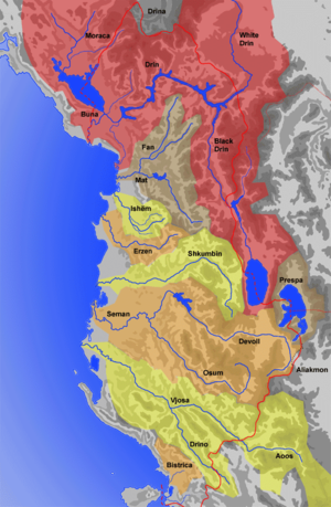
The Seman is a major river in western Albania. It is formed by the confluence of the rivers Devoll and Osum, a few km west of Kuçovë. It is 85 km (53 mi) long (281 km (175 mi) with its longest source river Devoll) and its drainage basin is 5,649 km2 (2,181 sq mi). Its average discharge is 95.7 m3/s (3,380 cu ft/s).[2] It meanders generally westwards through a flat lowland. Near Fier it receives from the left. It flows into the Adriatic Sea at the southern margin of the Divjakë-Karavasta National Park.
Name[]
In classical antiquity, the Seman River was known as the Apsus, which is a derivative of the Indo-European root *ăp- "water, river". The contemporary Albanian name Seman/Semen (definite form: Semani/Semeni), which is used to indicate the lower course of the river, evolved from *Apson- through Albanian phonetic changes. Also the contemporary Albanian name Osum (definite form: Osumi), which is used to indicate the lower course of the river, evolved from *Apsōn(em), but through Bulgarian phonetic changes.[3]
References[]
- ^ "The coastline of Albania : morphology, evolution and coastal management issues" (PDF). ciesm.org. p. 8.
- ^ Cullaj, A., Hasko, A., Miho, A., Schanz, F., Brandl, H. & Bachofen, R. (2005). "The quality of Albanian natural waters and the human impact". Environment International. 31: 137.CS1 maint: uses authors parameter (link)
- ^ Georgiev, Vladimir Ivanov (1981). Introduction to the History of the Indo-European Languages. Publishing House of the Bulgarian Academy of Sciences. p. 350. ISBN 978-953-51-7261-1.
This article about a specific location in Berat County, Albania, is a stub. You can help Wikipedia by . |
This article about a specific location in Fier County, Albania, is a stub. You can help Wikipedia by . |
- Rivers of Albania
- Geography of Berat County
- Geography of Fier County
- Seman basin
- Berat County geography stubs
- Fier County geography stubs
- Europe river stubs
- Albania geography stubs